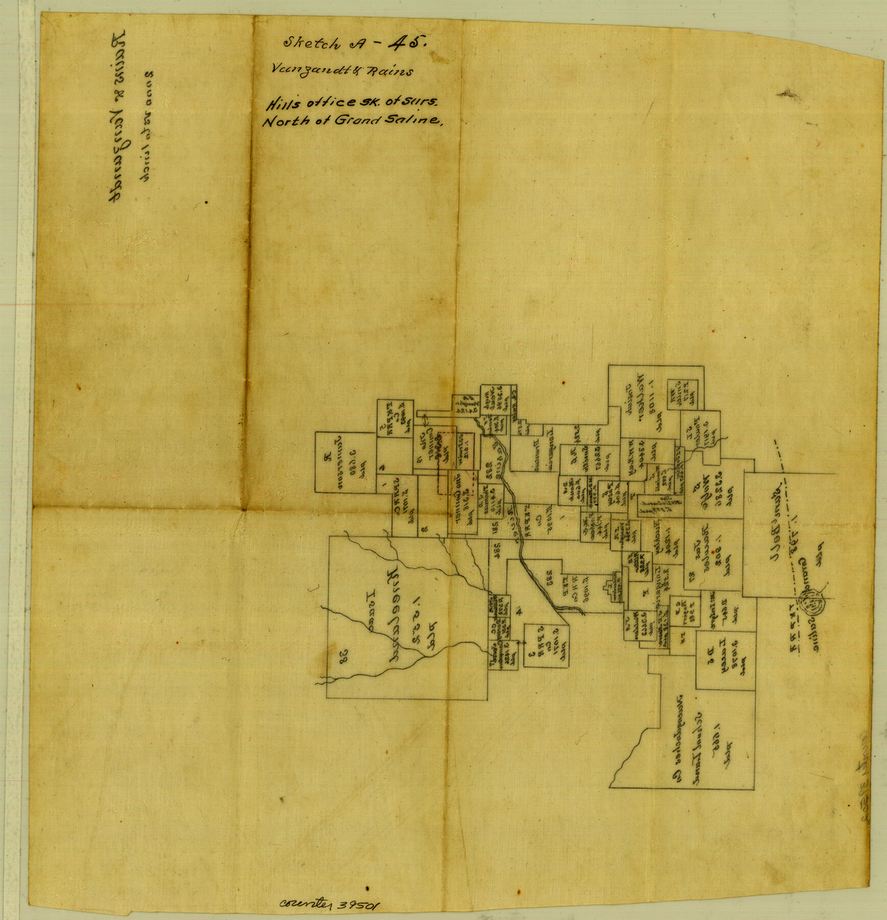
Van Zandt County Sketch File A45
[Office sketch of surveys north of Grand Saline in the northeast part of the county]
-
Map/Doc
39501
-
Collection
General Map Collection
-
People and Organizations
C.M. Hill (Draftsman)
-
Counties
Van Zandt Rains
-
Subjects
Surveying Sketch File
-
Height x Width
14.2 x 13.7 inches
36.1 x 34.8 cm
-
Medium
paper, manuscript
-
Features
Grande Saline Lake
Sabine River
T&P
Part of: General Map Collection
[Corpus Christi Bay, Padre Island, Mustang Island, Laguna de la Madre, King and Kenedy's Pasture]
![73043, [Corpus Christi Bay, Padre Island, Mustang Island, Laguna de la Madre, King and Kenedy's Pasture], General Map Collection](https://historictexasmaps.com/wmedia_w700/maps/73043.tif.jpg)
Print $20.00
- Digital $50.00
[Corpus Christi Bay, Padre Island, Mustang Island, Laguna de la Madre, King and Kenedy's Pasture]
Size 27.0 x 18.2 inches
Map/Doc 73043
Navarro County

Print $40.00
- Digital $50.00
Navarro County
1924
Size 42.5 x 49.0 inches
Map/Doc 95599
Township 1 North Range 11 West, North Western District, Louisiana

Print $20.00
- Digital $50.00
Township 1 North Range 11 West, North Western District, Louisiana
1884
Size 19.6 x 24.7 inches
Map/Doc 65878
[Untitled Map of Baja California & West Coast of Mexico]

Print $20.00
- Digital $50.00
[Untitled Map of Baja California & West Coast of Mexico]
1541
Size 11.1 x 16.7 inches
Map/Doc 97353
Garza County Sketch File 24

Print $8.00
- Digital $50.00
Garza County Sketch File 24
Size 9.1 x 7.7 inches
Map/Doc 24083
Runnels County Rolled Sketch 34

Print $20.00
- Digital $50.00
Runnels County Rolled Sketch 34
1950
Size 30.8 x 35.5 inches
Map/Doc 7521
Liberty County Rolled Sketch JLW

Print $40.00
- Digital $50.00
Liberty County Rolled Sketch JLW
1935
Size 28.0 x 85.5 inches
Map/Doc 9665
Marion County Working Sketch 9

Print $20.00
- Digital $50.00
Marion County Working Sketch 9
1940
Size 23.5 x 25.5 inches
Map/Doc 70784
Jim Hogg County Boundary File 3

Print $4.00
- Digital $50.00
Jim Hogg County Boundary File 3
Size 8.8 x 11.2 inches
Map/Doc 55529
Gray County Boundary File 7

Print $4.00
- Digital $50.00
Gray County Boundary File 7
Size 8.0 x 8.8 inches
Map/Doc 53898
Chambers County Boundary File 50

Print $42.00
- Digital $50.00
Chambers County Boundary File 50
Size 9.2 x 3.6 inches
Map/Doc 51267
Map of Encinal County

Print $20.00
- Digital $50.00
Map of Encinal County
1872
Size 30.5 x 20.3 inches
Map/Doc 3513
You may also like
Houston Ship Channel, Alexander Island to Carpenter Bayou

Print $20.00
- Digital $50.00
Houston Ship Channel, Alexander Island to Carpenter Bayou
1973
Size 35.2 x 46.9 inches
Map/Doc 69910
Live Oak County Sketch File 21

Print $26.00
- Digital $50.00
Live Oak County Sketch File 21
1912
Size 16.8 x 8.0 inches
Map/Doc 30297
[Sketch between Collingsworth County and Oklahoma]
![89673, [Sketch between Collingsworth County and Oklahoma], Twichell Survey Records](https://historictexasmaps.com/wmedia_w700/maps/89673-1.tif.jpg)
Print $40.00
- Digital $50.00
[Sketch between Collingsworth County and Oklahoma]
Size 63.2 x 9.1 inches
Map/Doc 89673
Hudspeth County Working Sketch Graphic Index

Print $40.00
- Digital $50.00
Hudspeth County Working Sketch Graphic Index
1943
Size 53.7 x 39.3 inches
Map/Doc 76584
Map of Refugio County

Print $20.00
- Digital $50.00
Map of Refugio County
1885
Size 19.8 x 25.9 inches
Map/Doc 3986
Flight Mission No. CRE-2R, Frame 155, Jackson County

Print $20.00
- Digital $50.00
Flight Mission No. CRE-2R, Frame 155, Jackson County
1956
Size 16.1 x 16.1 inches
Map/Doc 85366
Palo Pinto County Sketch File 23

Print $20.00
- Digital $50.00
Palo Pinto County Sketch File 23
1949
Size 23.5 x 15.4 inches
Map/Doc 12135
Map of Cherokee Co.

Print $40.00
- Digital $50.00
Map of Cherokee Co.
1902
Size 59.7 x 39.6 inches
Map/Doc 4747
General Highway Map, Hardeman County, Texas

Print $20.00
General Highway Map, Hardeman County, Texas
1940
Size 25.0 x 18.3 inches
Map/Doc 79113
Lubbock County Texas

Print $20.00
- Digital $50.00
Lubbock County Texas
Size 42.7 x 46.7 inches
Map/Doc 89892

Runnels County Sketch File 5a

Print $40.00
Runnels County Sketch File 5a
1883
Size 8.9 x 22.0 inches
Map/Doc 35438