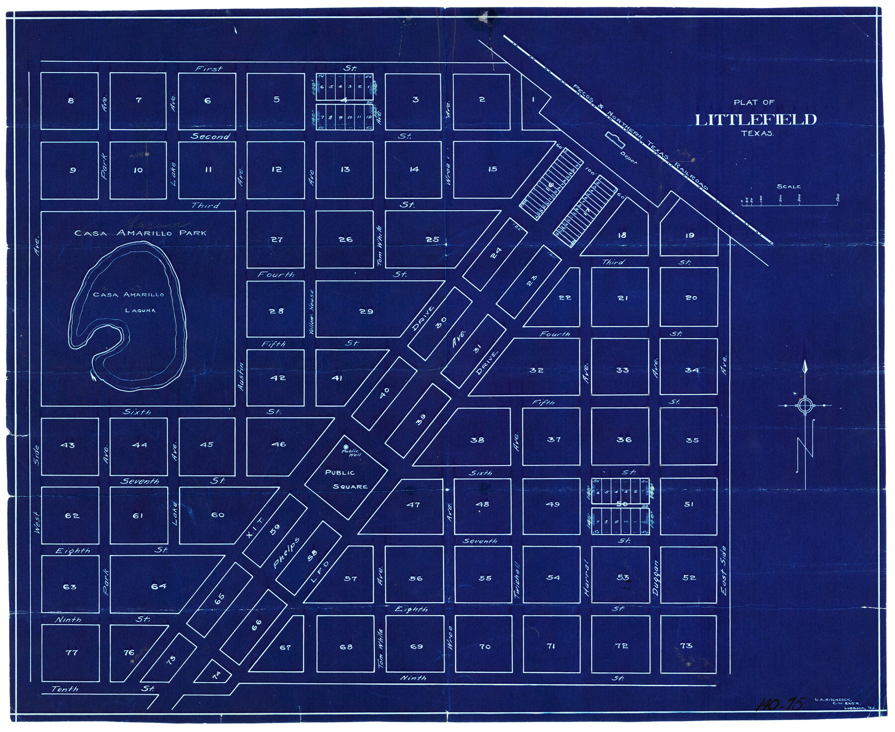
Plat of Littlefield, Texas
140-75
-
Map/Doc
90990
-
Collection
Twichell Survey Records
-
Counties
Lamb
-
Height x Width
23.6 x 19.3 inches
59.9 x 49.0 cm
Part of: Twichell Survey Records
[Surveys in the vicinity of Coyote Lake, Bailey County]
![90161, [Surveys in the vicinity of Coyote Lake, Bailey County], Twichell Survey Records](https://historictexasmaps.com/wmedia_w700/maps/90161-1.tif.jpg)
Print $20.00
- Digital $50.00
[Surveys in the vicinity of Coyote Lake, Bailey County]
1913
Size 26.8 x 26.7 inches
Map/Doc 90161
[League in the South Part of Lamb County]
![91052, [League in the South Part of Lamb County], Twichell Survey Records](https://historictexasmaps.com/wmedia_w700/maps/91052-1.tif.jpg)
Print $20.00
- Digital $50.00
[League in the South Part of Lamb County]
Size 30.4 x 34.1 inches
Map/Doc 91052
[Block B9 and 3KA]
![90329, [Block B9 and 3KA], Twichell Survey Records](https://historictexasmaps.com/wmedia_w700/maps/90329-1.tif.jpg)
Print $20.00
- Digital $50.00
[Block B9 and 3KA]
Size 31.4 x 17.8 inches
Map/Doc 90329
[Blocks 5-T, M-23, and vicinity]
![91230, [Blocks 5-T, M-23, and vicinity], Twichell Survey Records](https://historictexasmaps.com/wmedia_w700/maps/91230-1.tif.jpg)
Print $20.00
- Digital $50.00
[Blocks 5-T, M-23, and vicinity]
1890
Size 39.0 x 22.7 inches
Map/Doc 91230
[Parts of T. & P. 30 and 31, T3N, H. & T. C. 27]
![91206, [Parts of T. & P. 30 and 31, T3N, H. & T. C. 27], Twichell Survey Records](https://historictexasmaps.com/wmedia_w700/maps/91206-1.tif.jpg)
Print $20.00
- Digital $50.00
[Parts of T. & P. 30 and 31, T3N, H. & T. C. 27]
Size 17.4 x 14.4 inches
Map/Doc 91206
[Sketch showing the Northwest part of Hale County and the Northeast part of Lamb County]
![93204, [Sketch showing the Northwest part of Hale County and the Northeast part of Lamb County], Twichell Survey Records](https://historictexasmaps.com/wmedia_w700/maps/93204-1.tif.jpg)
Print $40.00
- Digital $50.00
[Sketch showing the Northwest part of Hale County and the Northeast part of Lamb County]
Size 55.1 x 57.3 inches
Map/Doc 93204
Survey of Improvements on Meeks Gin Site Town of Ropes Hockley County, Texas

Print $20.00
- Digital $50.00
Survey of Improvements on Meeks Gin Site Town of Ropes Hockley County, Texas
1957
Size 13.0 x 17.6 inches
Map/Doc 92214
[Blocks Surrounding I. G. Yates Section 34 1/2]
![92442, [Blocks Surrounding I. G. Yates Section 34 1/2], Twichell Survey Records](https://historictexasmaps.com/wmedia_w700/maps/92442-1.tif.jpg)
Print $20.00
- Digital $50.00
[Blocks Surrounding I. G. Yates Section 34 1/2]
Size 41.9 x 11.3 inches
Map/Doc 92442
Burma, Thailand, Indochina and Malayan Federation

Print $3.00
- Digital $50.00
Burma, Thailand, Indochina and Malayan Federation
Size 10.7 x 14.6 inches
Map/Doc 92376
Sundown Located on Tracts Number 58 and 59 Bob Slaughter Block Hockley County, Texas

Print $20.00
- Digital $50.00
Sundown Located on Tracts Number 58 and 59 Bob Slaughter Block Hockley County, Texas
1928
Size 21.4 x 19.4 inches
Map/Doc 92233
E. B. Shipp Irrigated Farm East Part Section 32, Block JS

Print $3.00
- Digital $50.00
E. B. Shipp Irrigated Farm East Part Section 32, Block JS
Size 9.3 x 16.7 inches
Map/Doc 92298
[Texas Boundary Line]
![92071, [Texas Boundary Line], Twichell Survey Records](https://historictexasmaps.com/wmedia_w700/maps/92071-1.tif.jpg)
Print $20.00
- Digital $50.00
[Texas Boundary Line]
Size 21.5 x 12.0 inches
Map/Doc 92071
You may also like
Flight Mission No. BRA-9M, Frame 73, Jefferson County

Print $20.00
- Digital $50.00
Flight Mission No. BRA-9M, Frame 73, Jefferson County
1953
Size 18.6 x 22.6 inches
Map/Doc 85656
Flight Mission No. DCL-7C, Frame 53, Kenedy County

Print $20.00
- Digital $50.00
Flight Mission No. DCL-7C, Frame 53, Kenedy County
1943
Size 16.7 x 16.4 inches
Map/Doc 86041
Map of Red River County

Print $20.00
- Digital $50.00
Map of Red River County
1842
Size 25.2 x 23.1 inches
Map/Doc 78369
Flight Mission No. CUG-2P, Frame 10, Kleberg County

Print $20.00
- Digital $50.00
Flight Mission No. CUG-2P, Frame 10, Kleberg County
1956
Size 18.7 x 22.3 inches
Map/Doc 86182
Duval County Boundary File 3j

Print $12.00
- Digital $50.00
Duval County Boundary File 3j
Size 12.8 x 8.0 inches
Map/Doc 52753
Burleson County Sketch File 3

Print $4.00
- Digital $50.00
Burleson County Sketch File 3
1848
Size 6.4 x 7.4 inches
Map/Doc 16647
Harris County Rolled Sketch 64

Print $20.00
- Digital $50.00
Harris County Rolled Sketch 64
1936
Size 35.0 x 40.3 inches
Map/Doc 9123
Flight Mission No. DQN-2K, Frame 147, Calhoun County

Print $20.00
- Digital $50.00
Flight Mission No. DQN-2K, Frame 147, Calhoun County
1953
Size 19.0 x 22.6 inches
Map/Doc 84316
Hutchinson County Rolled Sketch 44-15

Print $20.00
- Digital $50.00
Hutchinson County Rolled Sketch 44-15
2002
Size 24.0 x 36.0 inches
Map/Doc 77551
Orange County Working Sketch 17

Print $20.00
- Digital $50.00
Orange County Working Sketch 17
1930
Size 35.6 x 26.1 inches
Map/Doc 71349
Kent County Sketch File 11

Print $22.00
- Digital $50.00
Kent County Sketch File 11
1915
Size 7.9 x 8.6 inches
Map/Doc 28838
Map of the Country upon the Brazos and Big Witchita Rivers Explored in 1854 by Capt. R.B. Marcy 5th U.S. Infy. Embracing the Lands appropriated by the State of Texas for the Use of the Indians

Print $20.00
- Digital $50.00
Map of the Country upon the Brazos and Big Witchita Rivers Explored in 1854 by Capt. R.B. Marcy 5th U.S. Infy. Embracing the Lands appropriated by the State of Texas for the Use of the Indians
Size 29.6 x 33.8 inches
Map/Doc 93999