Aransas County Rolled Sketch 24
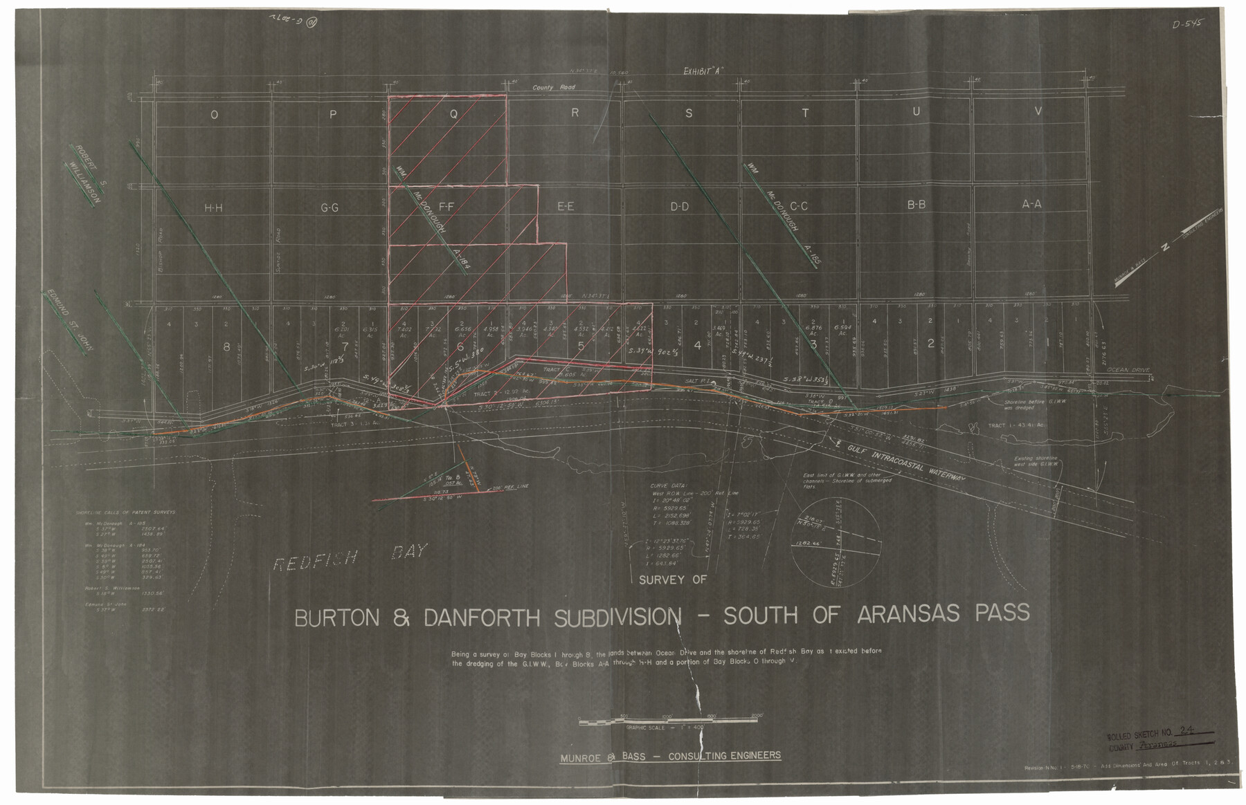
Survey of Burton & Danforth Subdivision - South of Aransas Pass being a survey of Bay Blocks 1 through 8, the lands between Ocean Drive and the shoreline of Redfish Bay as it existed before the dredging of the G.I.W.W.
-
Map/Doc
77495
-
Collection
General Map Collection
-
Object Dates
1970/5/18 (Revision Date)
1983/1/12 (File Date)
-
People and Organizations
Munroe & Bass (Surveyor/Engineer)
-
Counties
Aransas
-
Subjects
Surveying Rolled Sketch
-
Height x Width
22.5 x 34.8 inches
57.2 x 88.4 cm
-
Medium
van dyke/brownline/sepia
-
Scale
1" = 400'
Part of: General Map Collection
Flight Mission No. DQO-2K, Frame 92, Galveston County

Print $20.00
- Digital $50.00
Flight Mission No. DQO-2K, Frame 92, Galveston County
1952
Size 18.8 x 22.5 inches
Map/Doc 85019
Taylor County Working Sketch 5

Print $20.00
- Digital $50.00
Taylor County Working Sketch 5
1950
Size 31.1 x 24.7 inches
Map/Doc 69615
Loving County Rolled Sketch 3

Print $40.00
- Digital $50.00
Loving County Rolled Sketch 3
1952
Size 13.7 x 145.1 inches
Map/Doc 78185
Travis County Appraisal District Plat Map 2_2204

Print $20.00
- Digital $50.00
Travis County Appraisal District Plat Map 2_2204
Size 21.6 x 26.4 inches
Map/Doc 94201
Reeves County Sketch File 19

Print $9.00
- Digital $50.00
Reeves County Sketch File 19
1958
Size 11.3 x 8.9 inches
Map/Doc 35212
Johnson County Working Sketch 14

Print $20.00
- Digital $50.00
Johnson County Working Sketch 14
1974
Size 37.3 x 31.7 inches
Map/Doc 66627
Potter County Boundary File 3b

Print $12.00
- Digital $50.00
Potter County Boundary File 3b
Size 9.8 x 6.4 inches
Map/Doc 57979
Greer County Sketch File 3

Print $20.00
- Digital $50.00
Greer County Sketch File 3
Size 20.1 x 18.2 inches
Map/Doc 11583
Live Oak County Sketch File 19

Print $20.00
- Digital $50.00
Live Oak County Sketch File 19
1879
Size 24.7 x 18.3 inches
Map/Doc 4580
Flight Mission No. BRA-6M, Frame 79, Jefferson County

Print $20.00
- Digital $50.00
Flight Mission No. BRA-6M, Frame 79, Jefferson County
1953
Size 18.6 x 22.4 inches
Map/Doc 85423
Hudspeth County Sketch File 12

Print $10.00
- Digital $50.00
Hudspeth County Sketch File 12
1901
Size 14.2 x 8.7 inches
Map/Doc 26924
Map of Red River Division of the International & Great Northern Railroad

Print $40.00
- Digital $50.00
Map of Red River Division of the International & Great Northern Railroad
Size 24.1 x 107.0 inches
Map/Doc 64476
You may also like
Grayson County Working Sketch 5

Print $20.00
- Digital $50.00
Grayson County Working Sketch 5
1939
Size 28.4 x 40.6 inches
Map/Doc 63244
Newton County Sketch File 27

Print $4.00
- Digital $50.00
Newton County Sketch File 27
Size 13.0 x 8.6 inches
Map/Doc 32411

Williamson County

Print $20.00
- Digital $50.00
Williamson County
1872
Size 18.4 x 28.2 inches
Map/Doc 4151

Henderson County Working Sketch 16

Print $40.00
- Digital $50.00
Henderson County Working Sketch 16
1937
Size 49.9 x 30.9 inches
Map/Doc 66149
Wheelock Second Addition

Print $20.00
- Digital $50.00
Wheelock Second Addition
1952
Size 9.3 x 24.3 inches
Map/Doc 92308
Cameron County Sketch File 16

Print $18.00
- Digital $50.00
Cameron County Sketch File 16
1998
Size 11.2 x 8.6 inches
Map/Doc 76334
Shelby County Sketch File 16

Print $6.00
- Digital $50.00
Shelby County Sketch File 16
1873
Size 8.2 x 8.6 inches
Map/Doc 36626

Goliad County

Print $20.00
- Digital $50.00
Goliad County
1946
Size 42.8 x 45.0 inches
Map/Doc 73159
Jasper County Working Sketch 26

Print $20.00
- Digital $50.00
Jasper County Working Sketch 26
1953
Size 23.1 x 18.1 inches
Map/Doc 66488