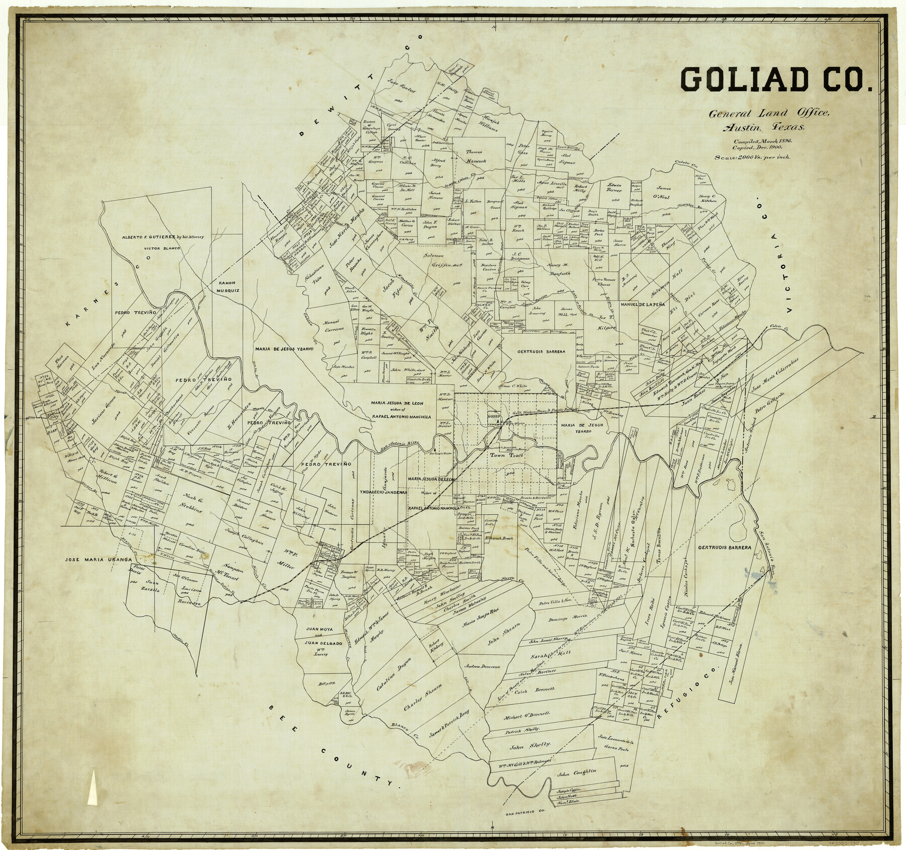
Goliad Co.
-
Map/Doc
4958
-
Collection
General Map Collection
-
Object Dates
3/1896 (Creation Date)
-
People and Organizations
Texas General Land Office (Publisher)
-
Counties
Goliad
-
Subjects
County
-
Height x Width
42.3 x 45.1 inches
107.4 x 114.6 cm
-
Comments
Compiled in March 1896; copied in December 1900.
Part of: General Map Collection
Schleicher County Sketch File 4

Print $20.00
- Digital $50.00
Schleicher County Sketch File 4
Size 18.8 x 16.1 inches
Map/Doc 12296
Corrected Map of Burnet County or Northern District of Houston County

Print $20.00
- Digital $50.00
Corrected Map of Burnet County or Northern District of Houston County
1845
Size 32.0 x 19.9 inches
Map/Doc 5052
Jefferson County Rolled Sketch 11

Print $40.00
- Digital $50.00
Jefferson County Rolled Sketch 11
Size 35.4 x 49.8 inches
Map/Doc 9277
Gaines County Rolled Sketch 33

Print $20.00
- Digital $50.00
Gaines County Rolled Sketch 33
1995
Size 17.4 x 18.2 inches
Map/Doc 76413
Frio County Sketch File 5

Print $4.00
- Digital $50.00
Frio County Sketch File 5
1878
Size 7.9 x 11.2 inches
Map/Doc 23116
Terrell County Rolled Sketch 14

Print $40.00
- Digital $50.00
Terrell County Rolled Sketch 14
Size 52.6 x 16.0 inches
Map/Doc 10309
Amistad International Reservoir on Rio Grande 69

Print $20.00
- Digital $50.00
Amistad International Reservoir on Rio Grande 69
1949
Size 28.4 x 39.4 inches
Map/Doc 73355
Angelina County Sketch File 25

Print $8.00
- Digital $50.00
Angelina County Sketch File 25
1894
Size 7.0 x 10.2 inches
Map/Doc 13069
Flight Mission No. DCL-7C, Frame 60, Kenedy County

Print $20.00
- Digital $50.00
Flight Mission No. DCL-7C, Frame 60, Kenedy County
1943
Size 15.3 x 15.3 inches
Map/Doc 86048
Crockett County Working Sketch 15

Print $20.00
- Digital $50.00
Crockett County Working Sketch 15
1916
Size 16.2 x 20.4 inches
Map/Doc 68348
Polk County Working Sketch 27

Print $40.00
- Digital $50.00
Polk County Working Sketch 27
1960
Size 45.9 x 51.2 inches
Map/Doc 71643
Flight Mission No. BQY-4M, Frame 63, Harris County

Print $20.00
- Digital $50.00
Flight Mission No. BQY-4M, Frame 63, Harris County
1953
Size 18.7 x 22.4 inches
Map/Doc 85272
You may also like
Location Through GC&SFRRCo., Runnels County, Texas

Print $20.00
- Digital $50.00
Location Through GC&SFRRCo., Runnels County, Texas
1898
Size 21.5 x 32.8 inches
Map/Doc 64509
Plat showing 52,500 acres of land in solid body located in Castro County, Texas

Print $20.00
- Digital $50.00
Plat showing 52,500 acres of land in solid body located in Castro County, Texas
Size 13.4 x 17.6 inches
Map/Doc 90404
Cherokee County Working Sketch 28

Print $20.00
- Digital $50.00
Cherokee County Working Sketch 28
1991
Size 13.7 x 16.8 inches
Map/Doc 67983
Hardeman County Boundary File 38

Print $70.00
- Digital $50.00
Hardeman County Boundary File 38
Size 12.9 x 8.2 inches
Map/Doc 54400
Kent County Boundary File 2

Print $4.00
- Digital $50.00
Kent County Boundary File 2
Size 10.1 x 8.2 inches
Map/Doc 55822
[Surveys along the Red River, Bois d'Arc Creek, Duck Creek, and Choctaw Bayou made under G.W. Smyth, Commissioner]
![74, [Surveys along the Red River, Bois d'Arc Creek, Duck Creek, and Choctaw Bayou made under G.W. Smyth, Commissioner], General Map Collection](https://historictexasmaps.com/wmedia_w700/maps/74.tif.jpg)
Print $20.00
- Digital $50.00
[Surveys along the Red River, Bois d'Arc Creek, Duck Creek, and Choctaw Bayou made under G.W. Smyth, Commissioner]
1834
Size 19.7 x 16.0 inches
Map/Doc 74
Flight Mission No. BQR-20K, Frame 4, Brazoria County

Print $20.00
- Digital $50.00
Flight Mission No. BQR-20K, Frame 4, Brazoria County
1952
Size 18.8 x 22.4 inches
Map/Doc 84106
Harbor Pass and Bar at Brazos Santiago, Texas

Print $20.00
- Digital $50.00
Harbor Pass and Bar at Brazos Santiago, Texas
1871
Size 18.1 x 27.4 inches
Map/Doc 73038
Go Turnpike! Dallas-Fort Worth Turnpike (Recto)

Go Turnpike! Dallas-Fort Worth Turnpike (Recto)
1963
Size 11.2 x 17.2 inches
Map/Doc 94177
Subdivision of Halsell Cattle Company's Sod House Pasture Situated in Lamb County, Texas

Print $20.00
- Digital $50.00
Subdivision of Halsell Cattle Company's Sod House Pasture Situated in Lamb County, Texas
Size 37.3 x 28.2 inches
Map/Doc 92169
Wilson County Sketch File 13

Print $4.00
- Digital $50.00
Wilson County Sketch File 13
1873
Size 10.2 x 8.0 inches
Map/Doc 40429
Taylor County Rolled Sketch 30A

Print $20.00
- Digital $50.00
Taylor County Rolled Sketch 30A
Size 17.5 x 11.3 inches
Map/Doc 76410