Reeves County Sketch File 19
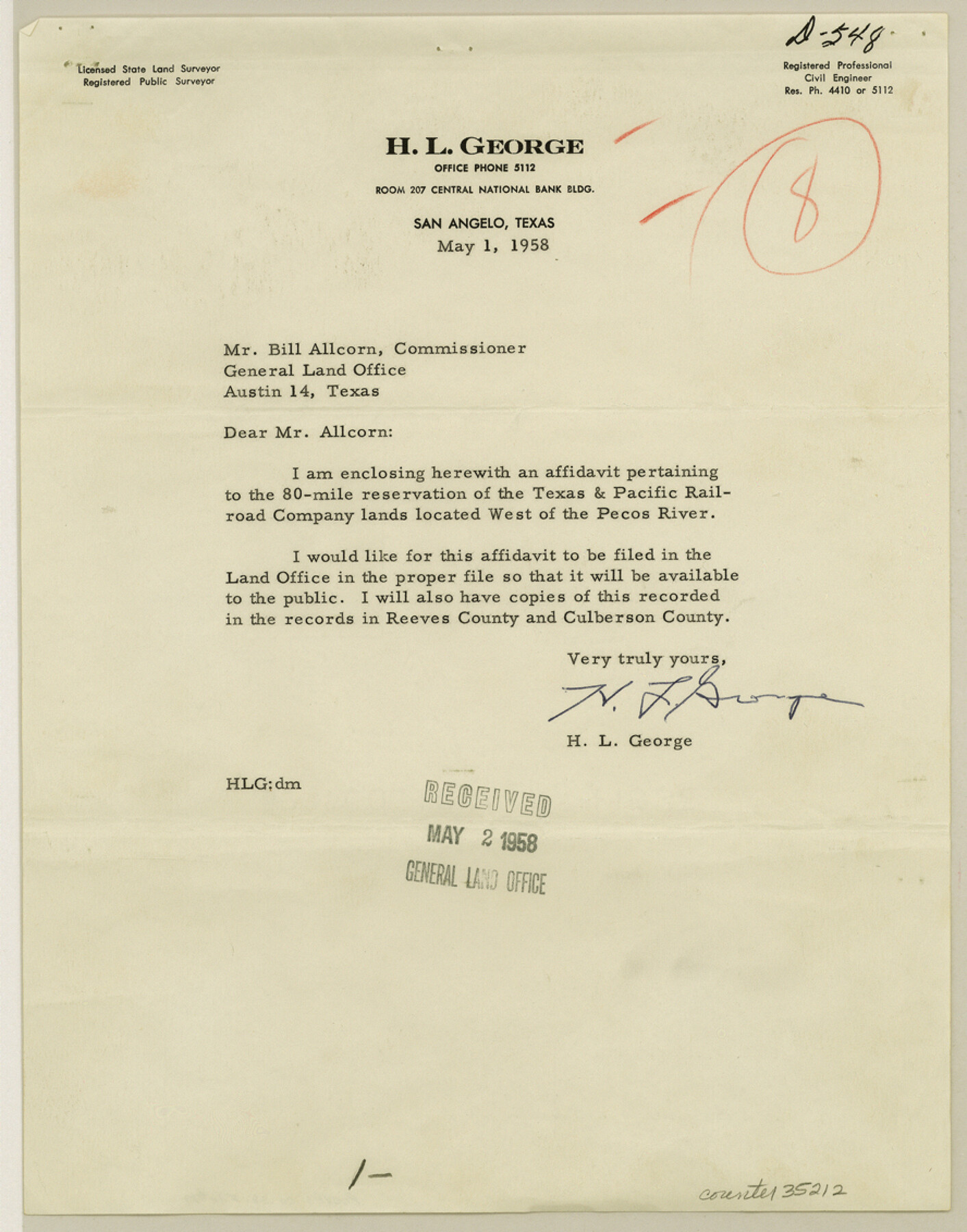
[Affidavit by H. L. George pertaining to the 80 mile reservation of the T. & P. RR. Co. lands located west of the Pecos River]
- 
                          Map/Doc35212
- 
                            CollectionGeneral Map Collection
- 
                            Object Dates1958/5/1 (Creation Date)1958/5/2 (File Date)1958/5/1 (Correspondence Date)1930 (Survey Date)1931 (Survey Date)1883 (Survey Date)1884 (Survey Date)
- 
                            People and OrganizationsH.L. George (Surveyor/Engineer)Paul McCombs (Surveyor/Engineer)Jacob Kuechler (Surveyor/Engineer)W.C. Walsh (GLO Commissioner)
- 
                            CountiesReeves
- 
                            SubjectsSurveying Sketch File
- 
                            Height x Width11.3 x 8.9 inches28.7 x 22.6 cm
- 
                            Mediumpaper, print
Part of: General Map Collection
            Tarrant's Key and Guide to Dallas


                                            Print $3.00                    
                                             -                         Digital $50.00                                    
                Tarrant's Key and Guide to Dallas
1922
Size 7.9 x 10.4 inches
                                Map/Doc 89257
            
            Gaines County


                                            Print $20.00                    
                                             -                         Digital $50.00                                    
                Gaines County
1956
Size 32.2 x 40.6 inches
                                Map/Doc 77286
            
            Wichita County Sketch File 8


                                            Print $4.00                    
                                             -                         Digital $50.00                                    
                Wichita County Sketch File 8
1860
Size 11.7 x 8.2 inches
                                Map/Doc 40048
            
            Grayson County Sketch File 20


                                            Print $4.00                    
                                             -                         Digital $50.00                                    
                Grayson County Sketch File 20
1861
Size 10.1 x 8.1 inches
                                Map/Doc 24493
            
            Menard County Boundary File 8


                                            Print $4.00                    
                                             -                         Digital $50.00                                    
                Menard County Boundary File 8
Size 11.1 x 8.7 inches
                                Map/Doc 57092
            
            Nueces River, Calallen Sheet


                                            Print $20.00                    
                                             -                         Digital $50.00                                    
                Nueces River, Calallen Sheet
1927
Size 32.7 x 37.3 inches
                                Map/Doc 65087
            
            Map of Washington District


                                            Print $20.00                    
                                             -                         Digital $50.00                                    
                Map of Washington District
1847
Size 17.6 x 26.8 inches
                                Map/Doc 4125
            
            [Gulf, Colorado & Santa Fe]
            
                                    ![64576, [Gulf, Colorado & Santa Fe], General Map Collection](https://historictexasmaps.com/wmedia_w700/maps/64576.tif.jpg) 


    ![64576, [Gulf, Colorado & Santa Fe], General Map Collection](https://historictexasmaps.com/wmedia_w700/maps/64576.tif.jpg) 
                                
            
                                            Print $40.00                    
                                             -                         Digital $50.00                                    
                [Gulf, Colorado & Santa Fe]
Size 32.4 x 84.9 inches
                                Map/Doc 64576
            
            Map of east part of West Bay & SW part of Galveston Bay, Galveston County showing subdivision for mineral development


                                            Print $40.00                    
                                             -                         Digital $50.00                                    
                Map of east part of West Bay & SW part of Galveston Bay, Galveston County showing subdivision for mineral development
1963
Size 64.1 x 45.4 inches
                                Map/Doc 3079
            
            Schleicher County Sketch File 42


                                            Print $40.00                    
                                             -                         Digital $50.00                                    
                Schleicher County Sketch File 42
1963
Size 16.3 x 14.4 inches
                                Map/Doc 36546
            
            Midland County Working Sketch 19a


                                            Print $20.00                    
                                             -                         Digital $50.00                                    
                Midland County Working Sketch 19a
Size 20.2 x 23.4 inches
                                Map/Doc 71000
            
            Presidio County Working Sketch 110


                                            Print $20.00                    
                                             -                         Digital $50.00                                    
                Presidio County Working Sketch 110
1981
Size 38.7 x 32.2 inches
                                Map/Doc 71787
            You may also like
            Pecos County Rolled Sketch 144


                                            Print $20.00                    
                                             -                         Digital $50.00                                    
                Pecos County Rolled Sketch 144
1956
Size 28.5 x 29.8 inches
                                Map/Doc 7277
            
            General Highway Map, Hutchinson County, Texas


                                            Print $20.00                    
                                    
                General Highway Map, Hutchinson County, Texas
1961
Size 18.1 x 24.6 inches
                                Map/Doc 79529
            
            Amérique Septentrionale


                                            Print $20.00                    
                                    
                Amérique Septentrionale
1845
Size 13.8 x 20.3 inches
                                Map/Doc 94571
            
            Robertson County Rolled Sketch 6


                                            Print $20.00                    
                                             -                         Digital $50.00                                    
                Robertson County Rolled Sketch 6
Size 22.8 x 15.6 inches
                                Map/Doc 7512
            
            Flight Mission No. DAG-24K, Frame 37, Matagorda County


                                            Print $20.00                    
                                             -                         Digital $50.00                                    
                Flight Mission No. DAG-24K, Frame 37, Matagorda County
1953
Size 18.5 x 22.2 inches
                                Map/Doc 86524
            
            Oldham County Sketch File 18


                                            Print $6.00                    
                                             -                         Digital $50.00                                    
                Oldham County Sketch File 18
1910
Size 8.9 x 8.5 inches
                                Map/Doc 33272
            
            Flight Mission No. CRC-2R, Frame 54, Chambers County


                                            Print $20.00                    
                                             -                         Digital $50.00                                    
                Flight Mission No. CRC-2R, Frame 54, Chambers County
1956
Size 18.5 x 22.3 inches
                                Map/Doc 84727
            
            Flight Mission No. BRA-16M, Frame 180, Jefferson County


                                            Print $20.00                    
                                             -                         Digital $50.00                                    
                Flight Mission No. BRA-16M, Frame 180, Jefferson County
1953
Size 18.5 x 22.4 inches
                                Map/Doc 85778
            
            Map of Shelby County


                                            Print $20.00                    
                                             -                         Digital $50.00                                    
                Map of Shelby County
1839
Size 24.5 x 25.7 inches
                                Map/Doc 4032
            
            Flight Mission No. CGI-3N, Frame 167, Cameron County


                                            Print $20.00                    
                                             -                         Digital $50.00                                    
                Flight Mission No. CGI-3N, Frame 167, Cameron County
1954
Size 18.6 x 22.4 inches
                                Map/Doc 84631
            
            Culberson County Sketch File 30


                                            Print $22.00                    
                                             -                         Digital $50.00                                    
                Culberson County Sketch File 30
1950
Size 14.2 x 8.7 inches
                                Map/Doc 20282
            
            Dickens County Rolled Sketch H


                                            Print $20.00                    
                                             -                         Digital $50.00                                    
                Dickens County Rolled Sketch H
1902
Size 26.4 x 19.1 inches
                                Map/Doc 5712
            