Duval County Sketch File 86
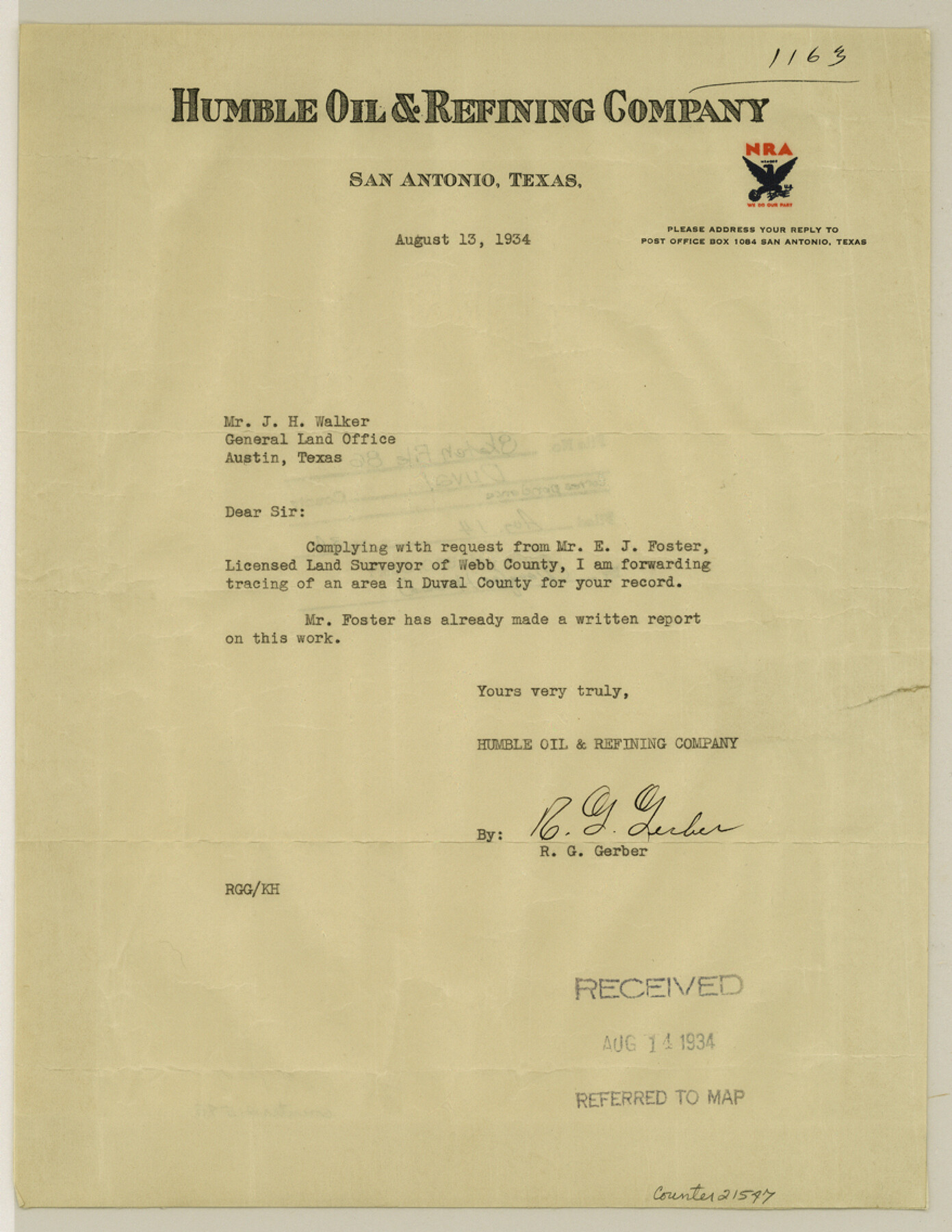
[Letter from R. G. Gerber to GLO Commissioner J. H. Walker]
Duval County Rolled Sketch EF
-
Map/Doc
21547
-
Collection
General Map Collection
-
Object Dates
1934/8/13 (Creation Date)
1934/8/14 (File Date)
-
People and Organizations
R.G. Gerber (Author)
-
Counties
Duval
-
Subjects
Surveying Sketch File
-
Height x Width
11.4 x 8.8 inches
29.0 x 22.4 cm
-
Medium
paper, print
-
Comments
See Duval County Rolled Sketch EF (5766) for sketch.
Related maps
Duval County Rolled Sketch EF

Print $20.00
- Digital $50.00
Duval County Rolled Sketch EF
1934
Size 26.8 x 35.0 inches
Map/Doc 5766
Part of: General Map Collection
Flight Mission No. DQN-3K, Frame 52, Calhoun County

Print $20.00
- Digital $50.00
Flight Mission No. DQN-3K, Frame 52, Calhoun County
1953
Size 18.4 x 22.2 inches
Map/Doc 84353
Hardin County Sketch File 51

Print $9.00
- Digital $50.00
Hardin County Sketch File 51
Size 9.9 x 8.1 inches
Map/Doc 25206
Pecos County Rolled Sketch 107

Print $20.00
- Digital $50.00
Pecos County Rolled Sketch 107
1940
Size 21.9 x 45.4 inches
Map/Doc 7253
McCulloch County Sketch File 14

Print $8.00
- Digital $50.00
McCulloch County Sketch File 14
1990
Size 11.2 x 8.7 inches
Map/Doc 31203
Flight Mission No. DQN-5K, Frame 52, Calhoun County

Print $20.00
- Digital $50.00
Flight Mission No. DQN-5K, Frame 52, Calhoun County
1953
Size 18.6 x 22.3 inches
Map/Doc 84397
Victoria County Rolled Sketch 6

Print $20.00
- Digital $50.00
Victoria County Rolled Sketch 6
Size 27.9 x 36.3 inches
Map/Doc 8152
Lamb County Sketch File 13

Print $42.00
- Digital $50.00
Lamb County Sketch File 13
1914
Size 9.1 x 8.6 inches
Map/Doc 29371
Bee County Working Sketch 22

Print $20.00
- Digital $50.00
Bee County Working Sketch 22
1983
Size 37.9 x 37.2 inches
Map/Doc 67272

Bosque County Sketch File 11

Print $4.00
- Digital $50.00
Bosque County Sketch File 11
1863
Size 10.2 x 8.3 inches
Map/Doc 14759

Uvalde County Working Sketch 67

Print $20.00
- Digital $50.00
Uvalde County Working Sketch 67
1956
Size 22.8 x 20.9 inches
Map/Doc 75973
You may also like
San Patricio County

Print $40.00
- Digital $50.00
San Patricio County
1939
Size 39.8 x 50.6 inches
Map/Doc 63019
Madison County Working Sketch 12

Print $40.00
- Digital $50.00
Madison County Working Sketch 12
1965
Size 41.7 x 48.5 inches
Map/Doc 70774
International and Great Northern Railroad Lone Star Route and Connections

Print $20.00
- Digital $50.00
International and Great Northern Railroad Lone Star Route and Connections
1877
Size 17.3 x 23.2 inches
Map/Doc 93462
Map of the State of Texas from the Latest Authorities

Print $20.00
- Digital $50.00
Map of the State of Texas from the Latest Authorities
1854
Size 13.1 x 16.1 inches
Map/Doc 93901
Duval County Sketch File 20 1/2

Print $4.00
- Digital $50.00
Duval County Sketch File 20 1/2
1880
Size 10.3 x 8.4 inches
Map/Doc 21324
Township No. 5 South Range No. 10 West of the Indian Meridian

Print $20.00
- Digital $50.00
Township No. 5 South Range No. 10 West of the Indian Meridian
1874
Size 19.2 x 24.5 inches
Map/Doc 75161
Montgomery County Working Sketch 25

Print $40.00
- Digital $50.00
Montgomery County Working Sketch 25
1941
Size 50.0 x 43.7 inches
Map/Doc 71132
Galveston County Working Sketch 1

Print $20.00
- Digital $50.00
Galveston County Working Sketch 1
Size 27.7 x 33.7 inches
Map/Doc 69338
Pecos County Rolled Sketch 103A

Print $20.00
- Digital $50.00
Pecos County Rolled Sketch 103A
1940
Size 29.3 x 33.4 inches
Map/Doc 7252
Sketch showing subdivision of surveys in Webb Co., Texas

Print $20.00
- Digital $50.00
Sketch showing subdivision of surveys in Webb Co., Texas
1933
Size 18.2 x 20.1 inches
Map/Doc 459
Nueces County Rolled Sketch 68A

Print $165.00
- Digital $50.00
Nueces County Rolled Sketch 68A
1980
Size 9.8 x 15.0 inches
Map/Doc 47898
Jackson County Sketch File 4

Print $20.00
- Digital $50.00
Jackson County Sketch File 4
Size 18.2 x 22.7 inches
Map/Doc 11834