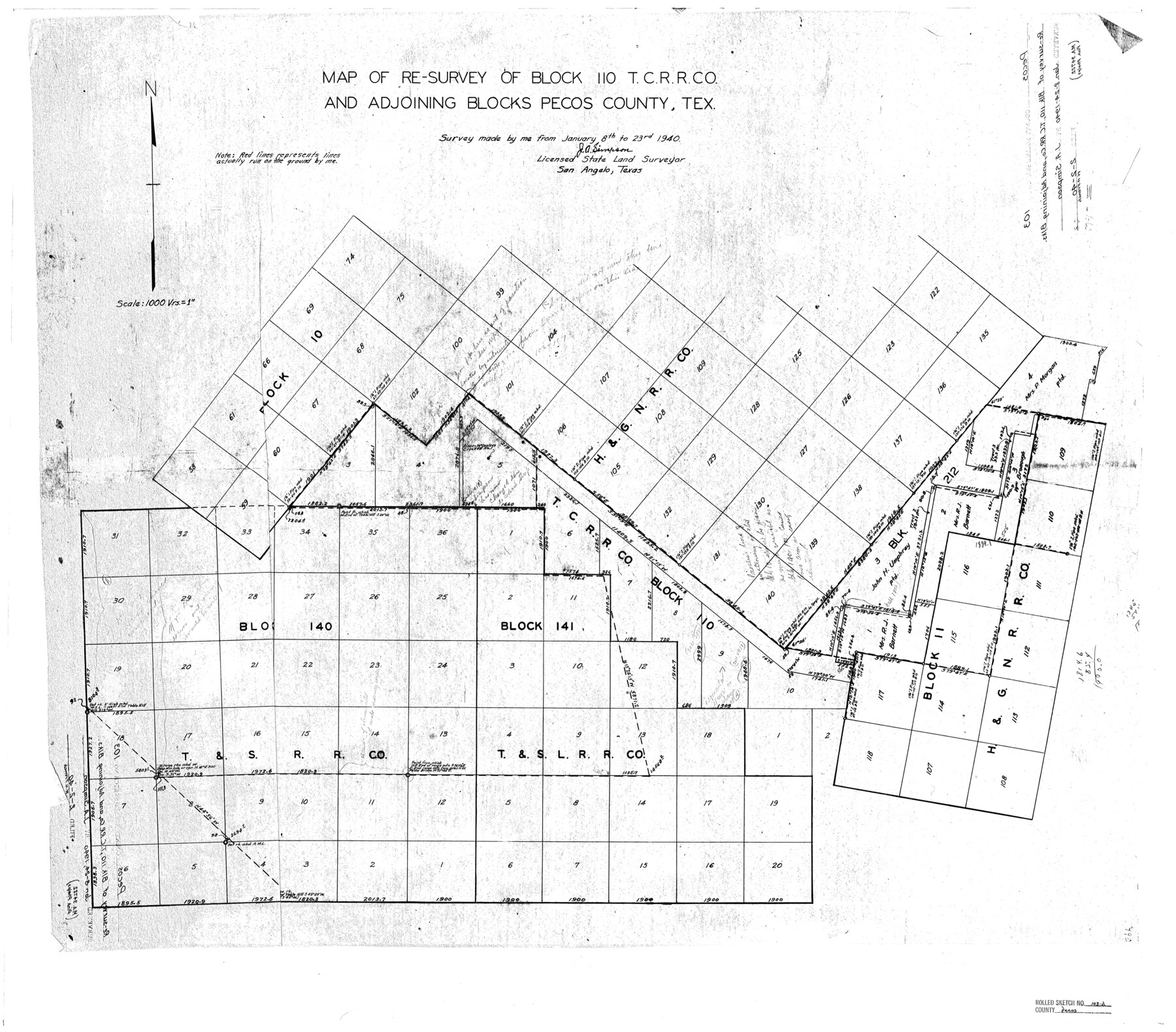
Pecos County Rolled Sketch 103A
Map of re-survey of Block 110, T. C. R.R. Co. and adjoining Blocks, Pecos County, Tex.
-
Map/Doc
7252
-
Collection
General Map Collection
-
Object Dates
1/23/1940 (Creation Date)
2/2/1940 (File Date)
-
People and Organizations
J.A. Simpson (Surveyor/Engineer)
-
Counties
Pecos
-
Subjects
Surveying Rolled Sketch
-
Height x Width
29.3 x 33.4 inches
74.4 x 84.8 cm
-
Scale
1" = 1000 varas
-
Comments
See Mineral Application file 34722. Also see Pecos County Rolled Sketch 105 (9717) for related sketch.
Related maps
Pecos County Rolled Sketch 105

Print $20.00
- Digital $50.00
Pecos County Rolled Sketch 105
1940
Size 30.7 x 37.7 inches
Map/Doc 9717
Part of: General Map Collection
Johnson County Working Sketch 15

Print $20.00
- Digital $50.00
Johnson County Working Sketch 15
1974
Size 21.6 x 23.8 inches
Map/Doc 66628
Louisiana and Texas Intracoastal Waterway, Section 7, Galveston Bay to Brazos River and Section 8, Brazos River to Matagorda Bay

Print $20.00
- Digital $50.00
Louisiana and Texas Intracoastal Waterway, Section 7, Galveston Bay to Brazos River and Section 8, Brazos River to Matagorda Bay
1928
Size 31.3 x 42.7 inches
Map/Doc 73065
Flight Mission No. DQN-5K, Frame 143, Calhoun County

Print $20.00
- Digital $50.00
Flight Mission No. DQN-5K, Frame 143, Calhoun County
1953
Size 18.8 x 22.3 inches
Map/Doc 84418
Nueces County Sketch File 12c

Print $11.00
- Digital $50.00
Nueces County Sketch File 12c
1889
Size 12.6 x 8.2 inches
Map/Doc 32534
Orange County Working Sketch 41

Print $20.00
- Digital $50.00
Orange County Working Sketch 41
1979
Size 28.0 x 18.2 inches
Map/Doc 71373
Nacogdoches County Sketch File 13

Print $6.00
- Digital $50.00
Nacogdoches County Sketch File 13
1883
Size 14.2 x 8.7 inches
Map/Doc 32256
Brewster County Rolled Sketch 115

Print $40.00
- Digital $50.00
Brewster County Rolled Sketch 115
1958
Size 11.5 x 138.4 inches
Map/Doc 8514
Harris County Boundary File 39 (1)

Print $45.00
- Digital $50.00
Harris County Boundary File 39 (1)
Size 4.5 x 16.3 inches
Map/Doc 54326
Webb County Boundary File 1a

Print $50.00
- Digital $50.00
Webb County Boundary File 1a
Size 14.3 x 9.0 inches
Map/Doc 59703
Reagan County Working Sketch 44

Print $20.00
- Digital $50.00
Reagan County Working Sketch 44
1987
Size 25.2 x 37.1 inches
Map/Doc 71886
Reagan County Rolled Sketch 28

Print $40.00
- Digital $50.00
Reagan County Rolled Sketch 28
1952
Size 64.1 x 46.5 inches
Map/Doc 9823
Lamb County Sketch File 8

Print $6.00
- Digital $50.00
Lamb County Sketch File 8
1904
Size 8.5 x 7.6 inches
Map/Doc 29355
You may also like
Pecos County Working Sketch 44

Print $20.00
- Digital $50.00
Pecos County Working Sketch 44
1945
Size 29.6 x 35.0 inches
Map/Doc 71516
Texas Pacific Land Trust, Preliminary Plat Blocks 64-65-66 Tsp. 7 & 8 T&P RR Co. Surveys

Print $40.00
- Digital $50.00
Texas Pacific Land Trust, Preliminary Plat Blocks 64-65-66 Tsp. 7 & 8 T&P RR Co. Surveys
1962
Size 54.6 x 43.0 inches
Map/Doc 87210
Jackson County Sketch File 3

Print $34.00
- Digital $50.00
Jackson County Sketch File 3
1875
Size 7.9 x 7.7 inches
Map/Doc 27621
Flight Mission No. DQO-7K, Frame 103, Galveston County

Print $20.00
- Digital $50.00
Flight Mission No. DQO-7K, Frame 103, Galveston County
1952
Size 18.5 x 22.7 inches
Map/Doc 85118
Medina County Working Sketch 33

Print $20.00
- Digital $50.00
Medina County Working Sketch 33
2006
Size 34.5 x 40.0 inches
Map/Doc 83607
[Block B, Sections 1-4]
![90984, [Block B, Sections 1-4], Twichell Survey Records](https://historictexasmaps.com/wmedia_w700/maps/90984-1.tif.jpg)
Print $20.00
- Digital $50.00
[Block B, Sections 1-4]
Size 21.8 x 20.5 inches
Map/Doc 90984
Wheeler County Sketch File 2

Print $26.00
- Digital $50.00
Wheeler County Sketch File 2
1881
Size 19.0 x 7.9 inches
Map/Doc 39994
Briscoe County Sketch File 6

Print $40.00
- Digital $50.00
Briscoe County Sketch File 6
Size 29.8 x 24.6 inches
Map/Doc 10995
Harris County Rolled Sketch O

Print $20.00
- Digital $50.00
Harris County Rolled Sketch O
Size 19.3 x 28.9 inches
Map/Doc 6141
Flight Mission No. BRA-6M, Frame 153, Jefferson County

Print $20.00
- Digital $50.00
Flight Mission No. BRA-6M, Frame 153, Jefferson County
1953
Size 18.5 x 22.2 inches
Map/Doc 85454
Cass County Working Sketch 21

Print $20.00
- Digital $50.00
Cass County Working Sketch 21
1961
Size 24.3 x 37.4 inches
Map/Doc 67924
Leon County Rolled Sketch 14A

Print $200.00
- Digital $50.00
Leon County Rolled Sketch 14A
1975
Size 16.5 x 35.5 inches
Map/Doc 46535