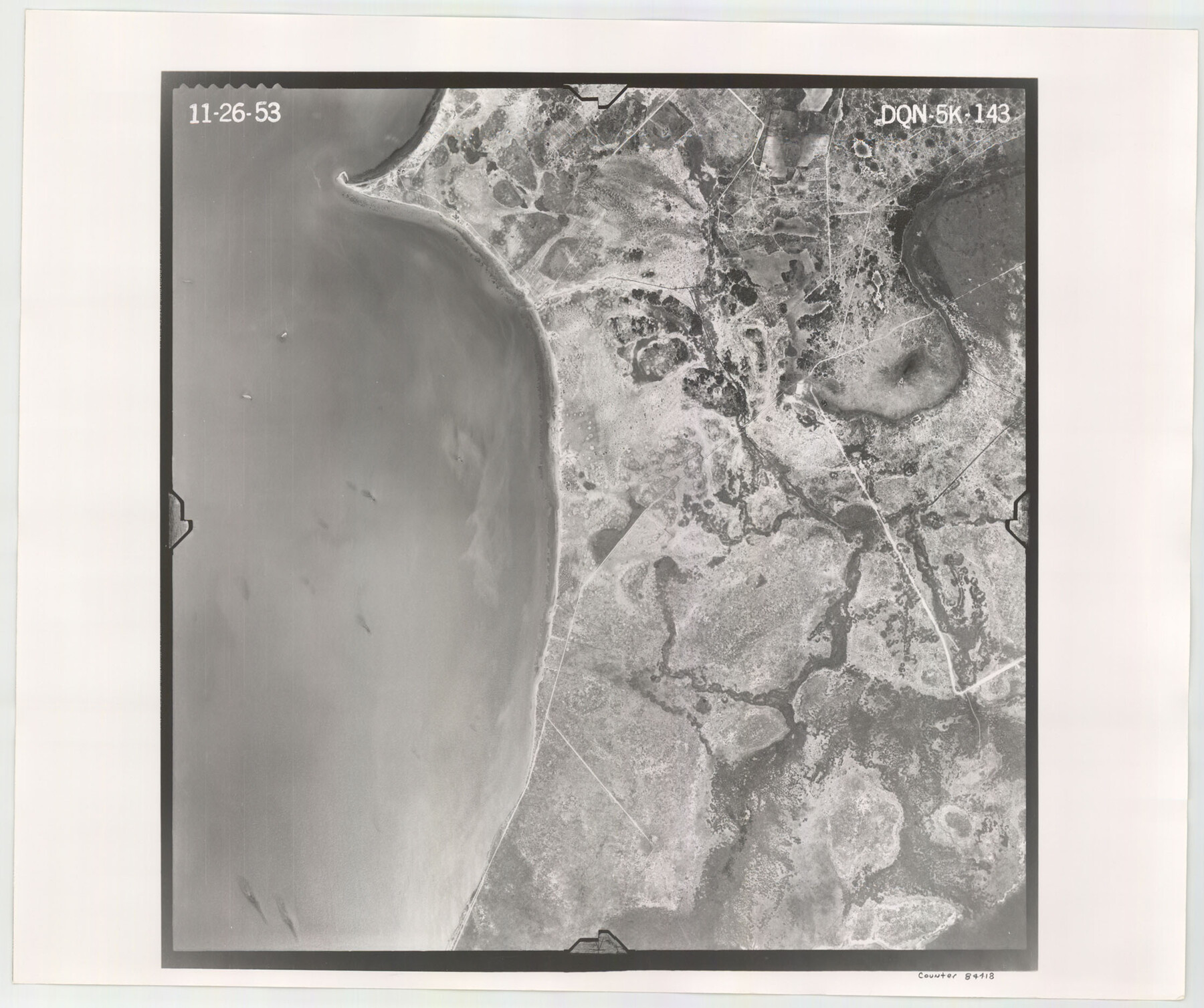
Flight Mission No. DQN-5K, Frame 143, Calhoun County
DQN-5K-143
-
Map/Doc
84418
-
Collection
General Map Collection
-
Object Dates
1953/11/26 (Creation Date)
-
People and Organizations
U. S. Department of Agriculture (Publisher)
-
Counties
Calhoun
-
Subjects
Aerial Photograph
-
Height x Width
18.8 x 22.3 inches
47.8 x 56.6 cm
-
Comments
Flown by Aero Exploration Company of Tulsa, Oklahoma.
Part of: General Map Collection
Approaches to Galveston Bay

Print $40.00
- Digital $50.00
Approaches to Galveston Bay
1989
Size 37.1 x 55.6 inches
Map/Doc 69887
Dallam County Working Sketch 2

Print $20.00
- Digital $50.00
Dallam County Working Sketch 2
1906
Size 38.5 x 24.1 inches
Map/Doc 68587
Flight Mission No. BQR-5K, Frame 64, Brazoria County

Print $20.00
- Digital $50.00
Flight Mission No. BQR-5K, Frame 64, Brazoria County
1952
Size 18.8 x 22.5 inches
Map/Doc 84009
Bandera County Boundary File 4

Print $18.00
- Digital $50.00
Bandera County Boundary File 4
Size 8.9 x 7.7 inches
Map/Doc 50267
Donley County Sketch File 1

Print $6.00
- Digital $50.00
Donley County Sketch File 1
Size 8.2 x 6.5 inches
Map/Doc 21214
Flight Mission No. BRE-2P, Frame 74, Nueces County

Print $20.00
- Digital $50.00
Flight Mission No. BRE-2P, Frame 74, Nueces County
1956
Size 18.5 x 22.3 inches
Map/Doc 86769
Red River County Working Sketch 10

Print $20.00
- Digital $50.00
Red River County Working Sketch 10
1920
Size 19.1 x 18.8 inches
Map/Doc 71993
Webb County Working Sketch 97

Print $20.00
- Digital $50.00
Webb County Working Sketch 97
1994
Size 27.1 x 30.6 inches
Map/Doc 72464
Amistad International Reservoir on Rio Grande 84

Print $20.00
- Digital $50.00
Amistad International Reservoir on Rio Grande 84
1949
Size 28.4 x 40.2 inches
Map/Doc 75513
Gillespie County

Print $40.00
- Digital $50.00
Gillespie County
1945
Size 41.0 x 50.0 inches
Map/Doc 95507
Montague County Boundary File 2c

Print $44.00
- Digital $50.00
Montague County Boundary File 2c
Size 9.0 x 14.5 inches
Map/Doc 57419
Flight Mission No. DQN-5K, Frame 50, Calhoun County

Print $20.00
- Digital $50.00
Flight Mission No. DQN-5K, Frame 50, Calhoun County
1953
Size 18.5 x 22.3 inches
Map/Doc 84395
You may also like
Yoakum County Sketch File 12

Print $22.00
- Digital $50.00
Yoakum County Sketch File 12
1933
Size 13.8 x 17.8 inches
Map/Doc 40765
[Gulf, Colorado & Santa Fe]
![64577, [Gulf, Colorado & Santa Fe], General Map Collection](https://historictexasmaps.com/wmedia_w700/maps/64577.tif.jpg)
Print $20.00
- Digital $50.00
[Gulf, Colorado & Santa Fe]
Size 32.4 x 47.4 inches
Map/Doc 64577
Loving County Working Sketch 22

Print $20.00
- Digital $50.00
Loving County Working Sketch 22
1984
Size 18.3 x 34.9 inches
Map/Doc 70656
[Surveys on Cibolo Creek]
![363, [Surveys on Cibolo Creek], General Map Collection](https://historictexasmaps.com/wmedia_w700/maps/363.tif.jpg)
Print $2.00
- Digital $50.00
[Surveys on Cibolo Creek]
Size 7.4 x 6.7 inches
Map/Doc 363
[Map showing J. H. Gibson Blocks D and DD]
![92000, [Map showing J. H. Gibson Blocks D and DD], Twichell Survey Records](https://historictexasmaps.com/wmedia_w700/maps/92000-1.tif.jpg)
Print $20.00
- Digital $50.00
[Map showing J. H. Gibson Blocks D and DD]
Size 26.1 x 18.8 inches
Map/Doc 92000
Hutchinson County Rolled Sketch 40

Print $20.00
- Digital $50.00
Hutchinson County Rolled Sketch 40
1981
Size 26.0 x 37.5 inches
Map/Doc 6302
Val Verde County Working Sketch 65

Print $20.00
- Digital $50.00
Val Verde County Working Sketch 65
1960
Size 30.9 x 31.8 inches
Map/Doc 72200
Fayette County Boundary File 7

Print $40.00
- Digital $50.00
Fayette County Boundary File 7
Size 18.1 x 13.1 inches
Map/Doc 53400
Flight Mission No. CUG-1P, Frame 42, Kleberg County

Print $20.00
- Digital $50.00
Flight Mission No. CUG-1P, Frame 42, Kleberg County
1956
Size 18.9 x 22.5 inches
Map/Doc 86120
Dawson County Sketch File 28

Print $20.00
- Digital $50.00
Dawson County Sketch File 28
1961
Size 46.0 x 15.3 inches
Map/Doc 10362
Polk County Working Sketch 39

Print $40.00
- Digital $50.00
Polk County Working Sketch 39
1978
Size 43.7 x 65.6 inches
Map/Doc 71656
[Leagues 701-714 and vicinity]
![90460, [Leagues 701-714 and vicinity], Twichell Survey Records](https://historictexasmaps.com/wmedia_w700/maps/90460-1.tif.jpg)
Print $20.00
- Digital $50.00
[Leagues 701-714 and vicinity]
Size 37.7 x 22.8 inches
Map/Doc 90460