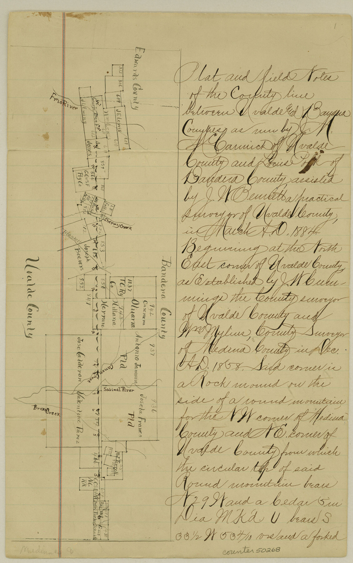
Bandera County Boundary File 4
Boundary line between Bandera and the Counties of Medina, Kerr and Uvalde
-
Map/Doc
50267
-
Collection
General Map Collection
-
Counties
Bandera
-
Subjects
County Boundaries
-
Height x Width
8.9 x 7.7 inches
22.6 x 19.6 cm
Part of: General Map Collection
Webb County Rolled Sketch 78A

Print $20.00
- Digital $50.00
Webb County Rolled Sketch 78A
Size 28.4 x 23.0 inches
Map/Doc 90053
Map of Tom Green Co.

Print $40.00
- Digital $50.00
Map of Tom Green Co.
1880
Size 42.3 x 51.2 inches
Map/Doc 80136
Lubbock County Sketch File 2

Print $4.00
- Digital $50.00
Lubbock County Sketch File 2
Size 4.7 x 9.2 inches
Map/Doc 30418
Williamson County Sketch File 32

Print $6.00
- Digital $50.00
Williamson County Sketch File 32
1986
Size 11.3 x 8.5 inches
Map/Doc 40393
Galveston County Sketch File 73

Print $78.00
- Digital $50.00
Galveston County Sketch File 73
1998
Size 11.3 x 8.8 inches
Map/Doc 23980
Current Miscellaneous File 8

Print $10.00
- Digital $50.00
Current Miscellaneous File 8
Size 14.6 x 9.1 inches
Map/Doc 73736
Kimble County Sketch File 17

Print $17.00
- Digital $50.00
Kimble County Sketch File 17
Size 11.5 x 8.5 inches
Map/Doc 28947
Map of the Fort Worth & Denver City Railway

Print $40.00
- Digital $50.00
Map of the Fort Worth & Denver City Railway
1887
Size 21.7 x 72.8 inches
Map/Doc 64479
Hemphill County Sketch File 10

Print $6.00
- Digital $50.00
Hemphill County Sketch File 10
1903
Size 14.3 x 8.8 inches
Map/Doc 26315
Harris County Rolled Sketch 86

Print $20.00
- Digital $50.00
Harris County Rolled Sketch 86
Size 20.7 x 42.9 inches
Map/Doc 73578
Tarrant County Sketch File 10a

Print $6.00
- Digital $50.00
Tarrant County Sketch File 10a
1860
Size 10.3 x 8.1 inches
Map/Doc 37691
Flight Mission No. CUG-3P, Frame 82, Kleberg County

Print $20.00
- Digital $50.00
Flight Mission No. CUG-3P, Frame 82, Kleberg County
1956
Size 18.6 x 22.2 inches
Map/Doc 86257
You may also like
Van Zandt County Sketch File 20

Print $4.00
- Digital $50.00
Van Zandt County Sketch File 20
1858
Size 12.1 x 7.9 inches
Map/Doc 39426
Lavaca County Working Sketch 21

Print $20.00
- Digital $50.00
Lavaca County Working Sketch 21
1982
Size 16.1 x 18.1 inches
Map/Doc 70374
Flight Mission No. DAG-17K, Frame 143, Matagorda County

Print $20.00
- Digital $50.00
Flight Mission No. DAG-17K, Frame 143, Matagorda County
1952
Size 16.4 x 16.4 inches
Map/Doc 86360
Pecos County Rolled Sketch JAS-1

Print $40.00
- Digital $50.00
Pecos County Rolled Sketch JAS-1
1936
Size 41.8 x 63.8 inches
Map/Doc 76146
Flight Mission No. BRE-3P, Frame 35, Nueces County

Print $20.00
- Digital $50.00
Flight Mission No. BRE-3P, Frame 35, Nueces County
1956
Size 18.5 x 21.1 inches
Map/Doc 86813
Tom Green County Sketch File 56

Print $20.00
- Digital $50.00
Tom Green County Sketch File 56
1883
Size 34.5 x 47.5 inches
Map/Doc 10404
Brewster County Rolled Sketch 101

Print $40.00
- Digital $50.00
Brewster County Rolled Sketch 101
1927
Size 74.2 x 42.3 inches
Map/Doc 9192

Burleson County Working Sketch 26

Print $20.00
- Digital $50.00
Burleson County Working Sketch 26
1981
Size 10.1 x 30.5 inches
Map/Doc 67745
[T. & P. RR. Lands and Surrounding surveys]
![91131, [T. & P. RR. Lands and Surrounding surveys], Twichell Survey Records](https://historictexasmaps.com/wmedia_w700/maps/91131.tif.jpg)
Print $20.00
- Digital $50.00
[T. & P. RR. Lands and Surrounding surveys]
1900
Size 16.4 x 12.2 inches
Map/Doc 91131
Newton County Sketch File 2

Print $6.00
- Digital $50.00
Newton County Sketch File 2
Size 14.0 x 10.7 inches
Map/Doc 32358
Childress County Sketch File 23

Print $4.00
- Digital $50.00
Childress County Sketch File 23
1892
Size 10.9 x 8.7 inches
Map/Doc 18382