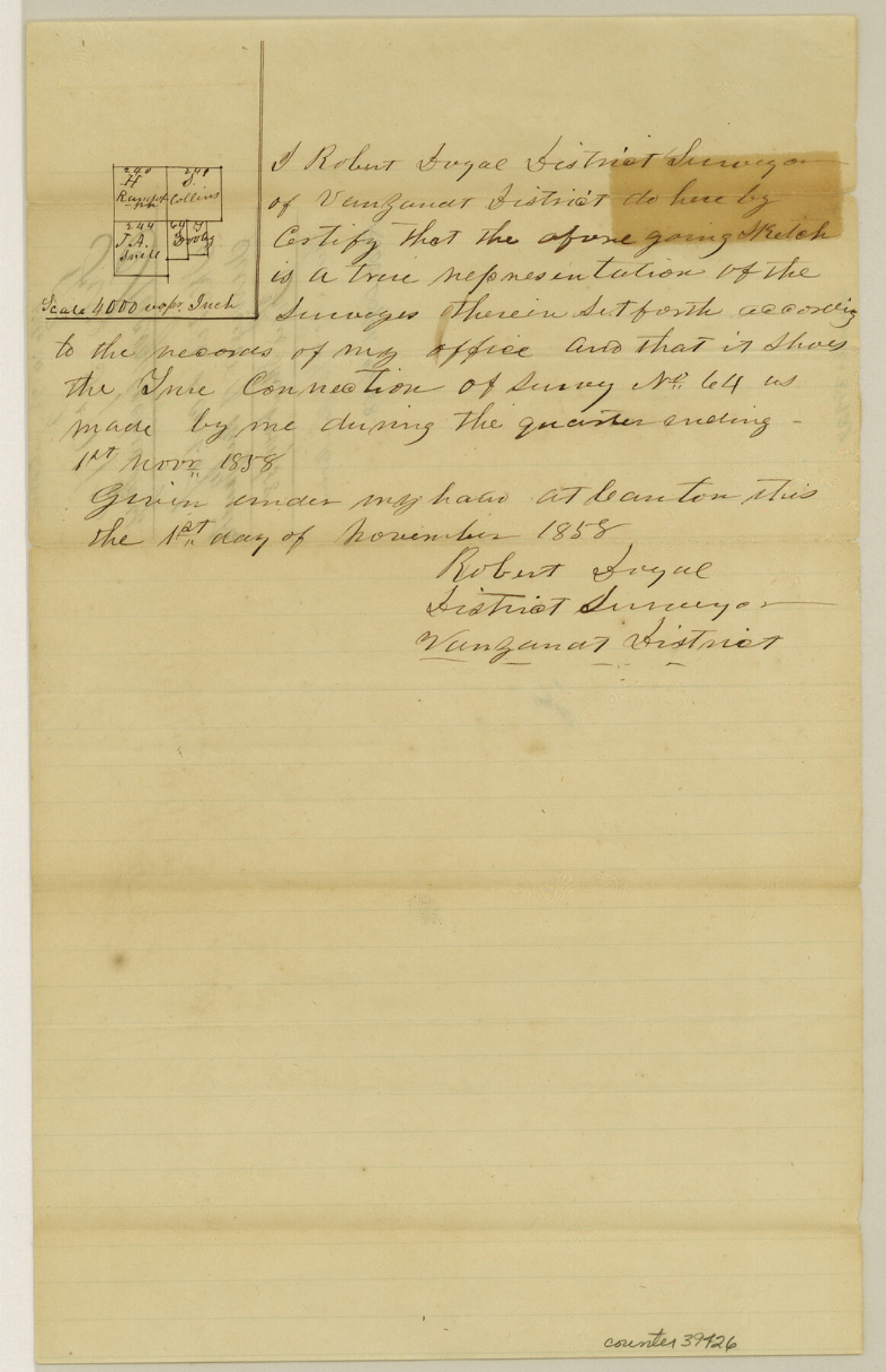
Van Zandt County Sketch File 20
[Sketch of surveys southeast from Canton]
-
Map/Doc
39426
-
Collection
General Map Collection
-
Object Dates
11/1/1858 (Creation Date)
11/8/1858 (File Date)
-
People and Organizations
Robert Doyal (Surveyor/Engineer)
-
Counties
Van Zandt
-
Subjects
Surveying Sketch File
-
Height x Width
12.1 x 7.9 inches
30.7 x 20.1 cm
-
Medium
paper, manuscript
-
Scale
1" = 4000 varas
Part of: General Map Collection
Flight Mission No. DCL-4C, Frame 145, Kenedy County

Print $20.00
- Digital $50.00
Flight Mission No. DCL-4C, Frame 145, Kenedy County
1943
Size 18.6 x 22.4 inches
Map/Doc 85823
San Jacinto County Sketch File 9

Print $4.00
San Jacinto County Sketch File 9
1860
Size 8.7 x 11.7 inches
Map/Doc 35712
City of Port Aransas

Print $40.00
- Digital $50.00
City of Port Aransas
1990
Size 25.2 x 53.3 inches
Map/Doc 3213
Wise County Sketch File 2

Print $8.00
- Digital $50.00
Wise County Sketch File 2
1856
Size 8.2 x 13.4 inches
Map/Doc 40523
[Surveys along the Colorado River]
![112, [Surveys along the Colorado River], General Map Collection](https://historictexasmaps.com/wmedia_w700/maps/112.tif.jpg)
Print $2.00
- Digital $50.00
[Surveys along the Colorado River]
1841
Size 12.2 x 8.3 inches
Map/Doc 112
Denton County Rolled Sketch 7

Print $20.00
- Digital $50.00
Denton County Rolled Sketch 7
2007
Size 24.5 x 19.3 inches
Map/Doc 87941
Greer County Sketch File 7

Print $40.00
- Digital $50.00
Greer County Sketch File 7
Size 12.8 x 17.5 inches
Map/Doc 24526
Cherokee County Working Sketch 28

Print $20.00
- Digital $50.00
Cherokee County Working Sketch 28
1991
Size 13.7 x 16.8 inches
Map/Doc 67983
Chambers County Sketch File 15

Print $4.00
- Digital $50.00
Chambers County Sketch File 15
Size 8.3 x 12.4 inches
Map/Doc 17563
Texas map showing principal forts

Print $20.00
- Digital $50.00
Texas map showing principal forts
1852
Size 34.7 x 25.1 inches
Map/Doc 2125
Gaines County Working Sketch 23

Print $20.00
- Digital $50.00
Gaines County Working Sketch 23
1982
Size 29.1 x 41.8 inches
Map/Doc 69323
Ward County Working Sketch 22

Print $20.00
- Digital $50.00
Ward County Working Sketch 22
1953
Size 19.5 x 20.7 inches
Map/Doc 72328
You may also like
Flight Mission No. BRE-1P, Frame 77, Nueces County

Print $20.00
- Digital $50.00
Flight Mission No. BRE-1P, Frame 77, Nueces County
1956
Size 18.4 x 22.2 inches
Map/Doc 86659
[Corner of Crosby, Lubbock, Lynn and Garza Counties]
![90905, [Corner of Crosby, Lubbock, Lynn and Garza Counties], Twichell Survey Records](https://historictexasmaps.com/wmedia_w700/maps/90905-1.tif.jpg)
Print $20.00
- Digital $50.00
[Corner of Crosby, Lubbock, Lynn and Garza Counties]
Size 36.0 x 22.8 inches
Map/Doc 90905
Descripçion de las Yndias del Norte

Print $20.00
- Digital $50.00
Descripçion de las Yndias del Norte
1601
Size 11.4 x 13.9 inches
Map/Doc 94850
Pecos County Rolled Sketch 168

Print $40.00
- Digital $50.00
Pecos County Rolled Sketch 168
Size 73.5 x 44.7 inches
Map/Doc 9748
Wilbarger County Aerial Photograph Index Sheet 3

Print $20.00
- Digital $50.00
Wilbarger County Aerial Photograph Index Sheet 3
1950
Size 22.5 x 18.9 inches
Map/Doc 83752
Outer Continental Shelf Leasing Maps (Louisiana Offshore Operations)

Print $20.00
- Digital $50.00
Outer Continental Shelf Leasing Maps (Louisiana Offshore Operations)
1955
Size 19.9 x 13.4 inches
Map/Doc 75860
Borden County Boundary File 2

Print $22.00
- Digital $50.00
Borden County Boundary File 2
Size 13.6 x 8.7 inches
Map/Doc 50614
[Borden County Lines - Description of County Line Markers]
![90215, [Borden County Lines - Description of County Line Markers], Twichell Survey Records](https://historictexasmaps.com/wmedia_w700/maps/90215-1.tif.jpg)
Print $3.00
- Digital $50.00
[Borden County Lines - Description of County Line Markers]
Size 14.4 x 10.1 inches
Map/Doc 90215
Coleman County Sketch File 49

Print $80.00
- Digital $50.00
Coleman County Sketch File 49
1918
Size 14.2 x 8.6 inches
Map/Doc 18813
Lampasas County Rolled Sketch 4

Print $20.00
- Digital $50.00
Lampasas County Rolled Sketch 4
2001
Size 27.1 x 38.5 inches
Map/Doc 6566
Presidio County Rolled Sketch 87

Print $20.00
- Digital $50.00
Presidio County Rolled Sketch 87
Size 26.4 x 38.2 inches
Map/Doc 7373
Crockett County Sketch File 69

Print $6.00
- Digital $50.00
Crockett County Sketch File 69
1931
Size 14.5 x 8.9 inches
Map/Doc 19855