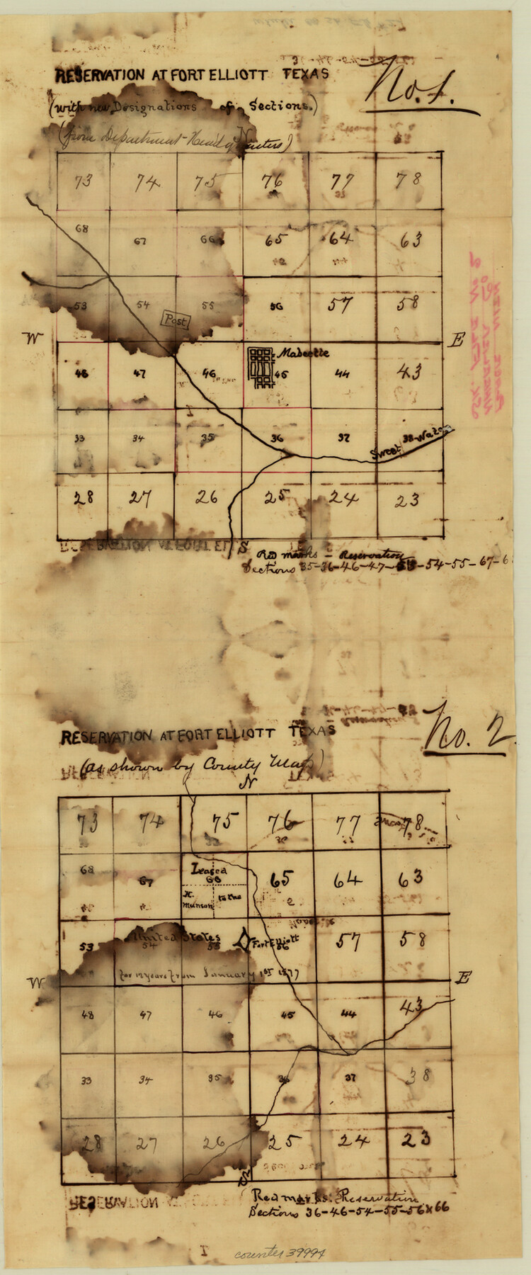
Wheeler County Sketch File 2
[Sketch and correspondence in reference to boundaries of the U.S. Reservation, Ft. Elliott]
-
Map/Doc
39994
-
Collection
General Map Collection
-
Object Dates
8/17/1881 (Creation Date)
-
People and Organizations
Henry E. Noyes (Surveyor/Engineer)
-
Counties
Wheeler
-
Subjects
Surveying Sketch File
-
Height x Width
19.0 x 7.9 inches
48.3 x 20.1 cm
-
Medium
paper, manuscript
-
Features
Reservation at Fort Elliott
Mobeetie
Sweet Water Creek
Fort Elliott
Part of: General Map Collection
Eastland County Working Sketch 63

Print $20.00
- Digital $50.00
Eastland County Working Sketch 63
1997
Size 36.7 x 37.6 inches
Map/Doc 68844
Tyler County Rolled Sketch 9

Print $20.00
- Digital $50.00
Tyler County Rolled Sketch 9
Size 43.3 x 25.6 inches
Map/Doc 8059
Kleberg County Boundary File 3

Print $10.00
- Digital $50.00
Kleberg County Boundary File 3
Size 9.5 x 6.1 inches
Map/Doc 64981
Brazoria County Sketch File 21

Print $4.00
- Digital $50.00
Brazoria County Sketch File 21
Size 8.3 x 7.5 inches
Map/Doc 15016
Val Verde County Sketch File B1

Print $20.00
- Digital $50.00
Val Verde County Sketch File B1
1905
Size 21.3 x 20.7 inches
Map/Doc 12543
Motley County Sketch File 3A (N)

Print $20.00
- Digital $50.00
Motley County Sketch File 3A (N)
Size 12.3 x 17.5 inches
Map/Doc 42136
El Paso County Sketch File 38

Print $4.00
- Digital $50.00
El Paso County Sketch File 38
1987
Size 14.3 x 8.9 inches
Map/Doc 22223
Brazos River, Ft. Griffin State Park/Mill Cr.-Clear Fork of Brazos River

Print $4.00
- Digital $50.00
Brazos River, Ft. Griffin State Park/Mill Cr.-Clear Fork of Brazos River
1940
Size 27.5 x 20.5 inches
Map/Doc 65291
Map of the Interior of Louisiana with a part of New Mexico

Print $20.00
- Digital $50.00
Map of the Interior of Louisiana with a part of New Mexico
1813
Size 11.9 x 15.7 inches
Map/Doc 94460
Flight Mission No. BRA-6M, Frame 91, Jefferson County

Print $20.00
- Digital $50.00
Flight Mission No. BRA-6M, Frame 91, Jefferson County
1953
Size 18.5 x 22.4 inches
Map/Doc 85434
[Portion of Panola Judicial District]
![78365, [Portion of Panola Judicial District], General Map Collection](https://historictexasmaps.com/wmedia_w700/maps/78365.tif.jpg)
Print $3.00
- Digital $50.00
[Portion of Panola Judicial District]
1841
Size 17.1 x 10.0 inches
Map/Doc 78365
You may also like

Duval County Rolled Sketch OS

Print $20.00
- Digital $50.00
Duval County Rolled Sketch OS
1903
Size 36.0 x 31.9 inches
Map/Doc 8803
Cooke County Boundary File 2a

Print $8.00
- Digital $50.00
Cooke County Boundary File 2a
Size 12.2 x 7.7 inches
Map/Doc 51849
Galveston County NRC Article 33.136 Sketch 75

Print $32.00
- Digital $50.00
Galveston County NRC Article 33.136 Sketch 75
2014
Size 24.0 x 36.0 inches
Map/Doc 95118
Potter County Working Sketch 11

Print $20.00
- Digital $50.00
Potter County Working Sketch 11
1972
Size 27.4 x 26.4 inches
Map/Doc 71671
Cooke County Working Sketch 37

Print $20.00
- Digital $50.00
Cooke County Working Sketch 37
1995
Size 21.7 x 18.9 inches
Map/Doc 68274
Travis County

Print $20.00
- Digital $50.00
Travis County
1895
Size 47.8 x 46.4 inches
Map/Doc 82079
Brazoria County NRC Article 33.136 Sketch 32

Print $24.00
Brazoria County NRC Article 33.136 Sketch 32
2025
Map/Doc 97490
Montague County Sketch File 6

Print $4.00
- Digital $50.00
Montague County Sketch File 6
1856
Size 8.0 x 8.4 inches
Map/Doc 31717
Western portion of the Ward Ranch, Cottle, Foard & Hardeman Counties, Swearingen, Texas sold to Luther T. Clark

Print $20.00
- Digital $50.00
Western portion of the Ward Ranch, Cottle, Foard & Hardeman Counties, Swearingen, Texas sold to Luther T. Clark
1916
Size 30.4 x 30.7 inches
Map/Doc 4460
Culberson County Working Sketch 74

Print $40.00
- Digital $50.00
Culberson County Working Sketch 74
1975
Size 51.4 x 35.5 inches
Map/Doc 68528
Burleson County Working Sketch 18

Print $20.00
- Digital $50.00
Burleson County Working Sketch 18
1980
Size 17.6 x 7.8 inches
Map/Doc 67737