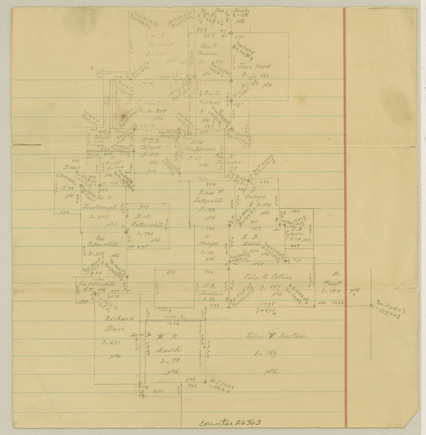
Henderson County Sketch File 19
[Pencil sketch around the Isaac W. Satterwhite survey in the northwest corner of Harrison County]
-
Map/Doc
26363
-
Collection
General Map Collection
-
People and Organizations
Pressler (Surveyor/Engineer)
-
Counties
Harrison
-
Subjects
Surveying Sketch File
-
Height x Width
9.1 x 8.9 inches
23.1 x 22.6 cm
-
Medium
paper, manuscript
Part of: General Map Collection
Dickens County

Print $20.00
- Digital $50.00
Dickens County
1880
Size 20.8 x 19.1 inches
Map/Doc 3485
Limestone County State Real Property Sketch 1

Print $20.00
- Digital $50.00
Limestone County State Real Property Sketch 1
2010
Size 35.9 x 24.6 inches
Map/Doc 89570
Brazoria County Rolled Sketch 36

Print $20.00
- Digital $50.00
Brazoria County Rolled Sketch 36
Size 18.5 x 25.0 inches
Map/Doc 5172
Bell County Sketch File 17

Print $4.00
- Digital $50.00
Bell County Sketch File 17
Size 8.1 x 9.1 inches
Map/Doc 14398
Right of Way and Track Map International & Gt. Northern Ry. operated by the International & Gt. Northern Ry. Co., Columbia Branch, Gulf Division

Print $40.00
- Digital $50.00
Right of Way and Track Map International & Gt. Northern Ry. operated by the International & Gt. Northern Ry. Co., Columbia Branch, Gulf Division
1917
Size 25.0 x 56.8 inches
Map/Doc 64599
Harrison County Working Sketch 12

Print $20.00
- Digital $50.00
Harrison County Working Sketch 12
1960
Size 26.6 x 31.4 inches
Map/Doc 66032
Cram's Superior Map of Illinois

Print $40.00
- Digital $50.00
Cram's Superior Map of Illinois
1903
Size 50.2 x 40.5 inches
Map/Doc 97110
Sutton County Sketch File 43

Print $20.00
- Digital $50.00
Sutton County Sketch File 43
Size 29.1 x 12.4 inches
Map/Doc 12391
Map of the Houston Ship Channel showing all industries, railways, public and private docks, and approximate all original surveys in the vicinity of the channel

Print $20.00
- Digital $50.00
Map of the Houston Ship Channel showing all industries, railways, public and private docks, and approximate all original surveys in the vicinity of the channel
1925
Size 14.5 x 30.2 inches
Map/Doc 4666
Presidio County Sketch File 5a

Print $4.00
- Digital $50.00
Presidio County Sketch File 5a
1872
Size 12.9 x 8.3 inches
Map/Doc 34435
Angelina County Sketch File 19

Print $22.00
- Digital $50.00
Angelina County Sketch File 19
1876
Size 8.2 x 12.6 inches
Map/Doc 13036
Map of The Surveyed Part of Peters Colony Texas

Print $40.00
- Digital $50.00
Map of The Surveyed Part of Peters Colony Texas
1852
Size 53.0 x 28.1 inches
Map/Doc 1964
You may also like
PSL Field Notes for Block JKL in Hudspeth County

PSL Field Notes for Block JKL in Hudspeth County
Map/Doc 81658
Val Verde County Working Sketch 58

Print $20.00
- Digital $50.00
Val Verde County Working Sketch 58
1958
Size 21.0 x 22.8 inches
Map/Doc 72193
Map of the Cotton Belt Route, St. Louis Southwestern Railway Co., St. Louis Southwestern Railway Co. of Texas, Tyler Southeastern Railway Co. and connections

Print $20.00
- Digital $50.00
Map of the Cotton Belt Route, St. Louis Southwestern Railway Co., St. Louis Southwestern Railway Co. of Texas, Tyler Southeastern Railway Co. and connections
1898
Size 15.3 x 35.7 inches
Map/Doc 93954
Map of the West Part of Tom Green County

Print $20.00
- Digital $50.00
Map of the West Part of Tom Green County
1894
Size 46.9 x 34.7 inches
Map/Doc 63072
Sherman County Boundary File 2a

Print $10.00
- Digital $50.00
Sherman County Boundary File 2a
Size 12.9 x 8.9 inches
Map/Doc 58768
Medina County Working Sketch 2

Print $20.00
- Digital $50.00
Medina County Working Sketch 2
1942
Size 30.3 x 31.0 inches
Map/Doc 70917
Bastrop County Working Sketch 3

Print $20.00
- Digital $50.00
Bastrop County Working Sketch 3
1921
Size 22.9 x 15.4 inches
Map/Doc 67303
Houston County Rolled Sketch 9

Print $20.00
- Digital $50.00
Houston County Rolled Sketch 9
1980
Size 27.5 x 26.6 inches
Map/Doc 6229
Fisher County Working Sketch 5

Print $20.00
- Digital $50.00
Fisher County Working Sketch 5
1926
Size 23.0 x 25.6 inches
Map/Doc 69139


Navigation Maps of Gulf Intracoastal Waterway, Port Arthur to Brownsville, Texas

Print $4.00
- Digital $50.00
Navigation Maps of Gulf Intracoastal Waterway, Port Arthur to Brownsville, Texas
1951
Size 16.7 x 21.5 inches
Map/Doc 65428