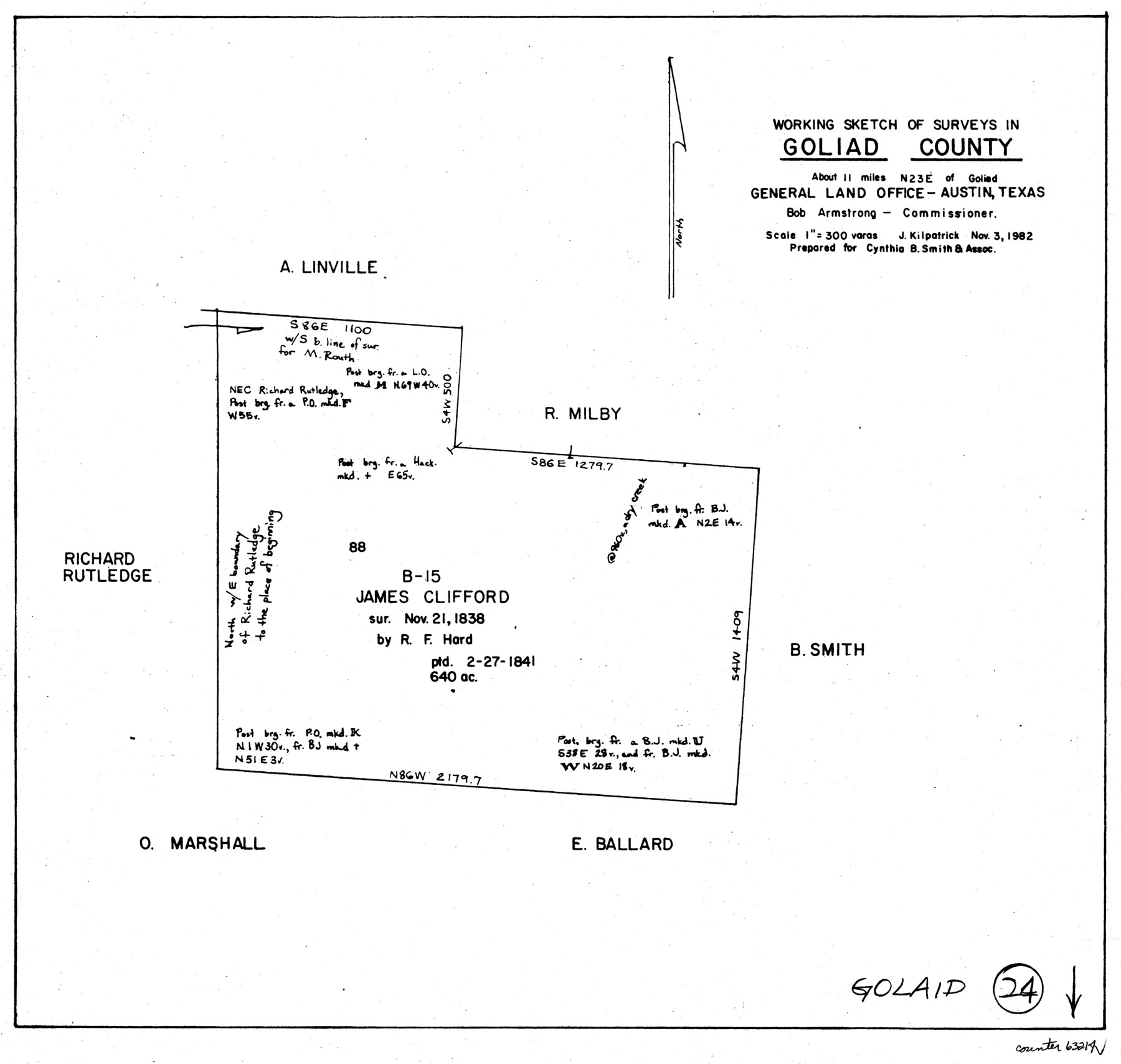
Goliad County Working Sketch 24
-
Map/Doc
63214
-
Collection
General Map Collection
-
Object Dates
11/3/1982 (Creation Date)
-
People and Organizations
Joan Kilpatrick (Draftsman)
-
Counties
Goliad
-
Subjects
Surveying Working Sketch
-
Height x Width
14.9 x 15.7 inches
37.9 x 39.9 cm
-
Scale
1" = 300 varas
Part of: General Map Collection
[Sketch for Mineral Application 17237 / Mineral File 11855 - Neches River, Joe A. Sanders]
![65687, [Sketch for Mineral Application 17237 / Mineral File 11855 - Neches River, Joe A. Sanders], General Map Collection](https://historictexasmaps.com/wmedia_w700/maps/65687.tif.jpg)
Print $40.00
- Digital $50.00
[Sketch for Mineral Application 17237 / Mineral File 11855 - Neches River, Joe A. Sanders]
1927
Size 78.5 x 31.2 inches
Map/Doc 65687
Morris County Rolled Sketch 2A

Print $20.00
- Digital $50.00
Morris County Rolled Sketch 2A
Size 24.0 x 18.8 inches
Map/Doc 10273
Freestone County Working Sketch 11

Print $40.00
- Digital $50.00
Freestone County Working Sketch 11
1978
Size 31.4 x 51.4 inches
Map/Doc 69253
King County Sketch File 7A

Print $28.00
- Digital $50.00
King County Sketch File 7A
1902
Size 22.1 x 34.7 inches
Map/Doc 11936
Public Land on Mustang Island, Nueces County

Print $20.00
- Digital $50.00
Public Land on Mustang Island, Nueces County
1910
Size 17.0 x 17.5 inches
Map/Doc 1997
Flight Mission No. BRA-7M, Frame 27, Jefferson County

Print $20.00
- Digital $50.00
Flight Mission No. BRA-7M, Frame 27, Jefferson County
1953
Size 18.5 x 22.3 inches
Map/Doc 85478
Flight Mission No. CRC-4R, Frame 75, Chambers County

Print $20.00
- Digital $50.00
Flight Mission No. CRC-4R, Frame 75, Chambers County
1956
Size 18.6 x 22.3 inches
Map/Doc 84879
[Lower Part of Milam District]
![1961, [Lower Part of Milam District], General Map Collection](https://historictexasmaps.com/wmedia_w700/maps/1961.tif.jpg)
Print $20.00
- Digital $50.00
[Lower Part of Milam District]
1850
Size 46.5 x 44.2 inches
Map/Doc 1961
Duval County Working Sketch 57

Print $20.00
- Digital $50.00
Duval County Working Sketch 57
1990
Size 30.3 x 25.4 inches
Map/Doc 68781
Brewster County Rolled Sketch 134

Print $20.00
- Digital $50.00
Brewster County Rolled Sketch 134
Size 19.0 x 24.9 inches
Map/Doc 5303
Hays County Working Sketch 22

Print $20.00
- Digital $50.00
Hays County Working Sketch 22
2000
Size 47.1 x 36.9 inches
Map/Doc 76051
Morris County Rolled Sketch 2A

Print $20.00
- Digital $50.00
Morris County Rolled Sketch 2A
Size 22.7 x 17.6 inches
Map/Doc 10268
You may also like

Hood County Sketch File 28

Print $84.00
- Digital $50.00
Hood County Sketch File 28
1880
Size 11.6 x 9.0 inches
Map/Doc 26631
[Sketch of part of G. & M. Block 5, G. & M. Block 4, Block M19 and Block 21W]
![93081, [Sketch of part of G. & M. Block 5, G. & M. Block 4, Block M19 and Block 21W], Twichell Survey Records](https://historictexasmaps.com/wmedia_w700/maps/93081-1.tif.jpg)
Print $20.00
- Digital $50.00
[Sketch of part of G. & M. Block 5, G. & M. Block 4, Block M19 and Block 21W]
Size 21.7 x 16.6 inches
Map/Doc 93081
Flight Mission No. DQN-1K, Frame 155, Calhoun County

Print $20.00
- Digital $50.00
Flight Mission No. DQN-1K, Frame 155, Calhoun County
1953
Size 18.5 x 22.2 inches
Map/Doc 84214
Upton County Rolled Sketch 26

Print $20.00
- Digital $50.00
Upton County Rolled Sketch 26
1942
Size 35.7 x 37.2 inches
Map/Doc 10045
Flight Mission No. DCL-6C, Frame 158, Kenedy County

Print $20.00
- Digital $50.00
Flight Mission No. DCL-6C, Frame 158, Kenedy County
1943
Size 15.3 x 15.2 inches
Map/Doc 85984
Uvalde County

Print $20.00
- Digital $50.00
Uvalde County
1915
Size 43.4 x 46.4 inches
Map/Doc 63092
Blanco County Sketch File 31

Print $4.00
- Digital $50.00
Blanco County Sketch File 31
Size 11.1 x 8.6 inches
Map/Doc 14629

Hartley County

Print $20.00
- Digital $50.00
Hartley County
1892
Size 25.0 x 20.0 inches
Map/Doc 90670
Coryell County Rolled Sketch 3

Print $20.00
- Digital $50.00
Coryell County Rolled Sketch 3
1974
Size 24.6 x 36.4 inches
Map/Doc 5567
Cameron County Rolled Sketch 7A

Print $20.00
- Digital $50.00
Cameron County Rolled Sketch 7A
1926
Size 30.2 x 34.0 inches
Map/Doc 5384