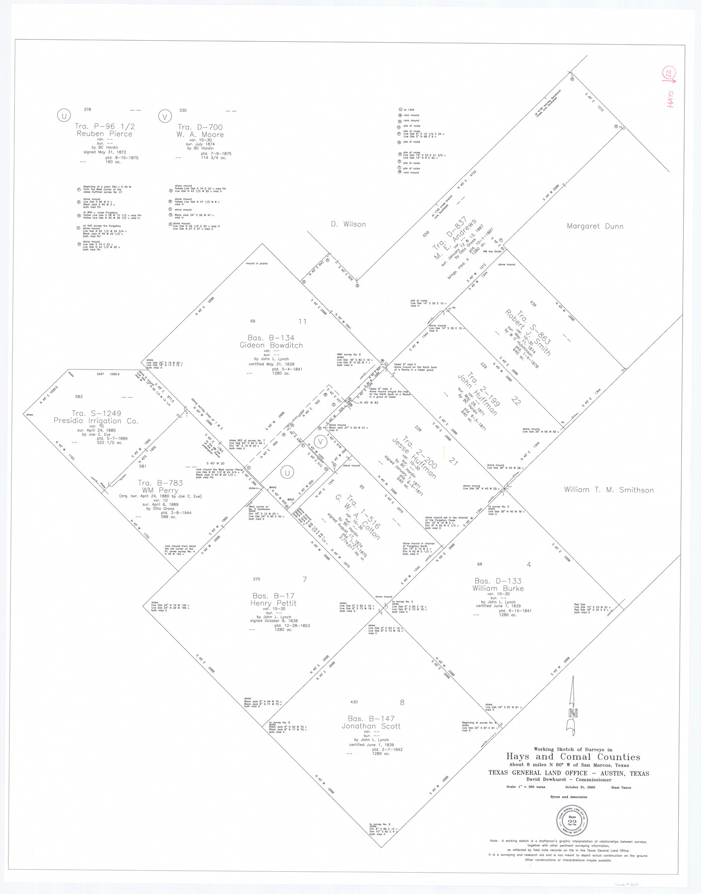
Hays County Working Sketch 22
-
Map/Doc
76051
-
Collection
General Map Collection
-
Object Dates
10/31/2000 (Creation Date)
-
People and Organizations
Stasi Vance (Draftsman)
-
Counties
Hays Comal
-
Subjects
Surveying Working Sketch
-
Height x Width
47.1 x 36.9 inches
119.6 x 93.7 cm
-
Scale
1" = 300 varas
Part of: General Map Collection
Flight Mission No. DAH-9M, Frame 155, Orange County

Print $20.00
- Digital $50.00
Flight Mission No. DAH-9M, Frame 155, Orange County
1953
Size 18.6 x 22.6 inches
Map/Doc 86854
Dépt. de la Nièvre

Print $20.00
- Digital $50.00
Dépt. de la Nièvre
Size 14.5 x 20.3 inches
Map/Doc 94452
Upshur County Working Sketch 14

Print $20.00
- Digital $50.00
Upshur County Working Sketch 14
1993
Size 23.1 x 37.1 inches
Map/Doc 69571
Flight Mission No. DIX-10P, Frame 183, Aransas County

Print $20.00
- Digital $50.00
Flight Mission No. DIX-10P, Frame 183, Aransas County
1956
Size 18.4 x 22.1 inches
Map/Doc 83973
Flight Mission No. BRE-2P, Frame 74, Nueces County

Print $20.00
- Digital $50.00
Flight Mission No. BRE-2P, Frame 74, Nueces County
1956
Size 18.5 x 22.3 inches
Map/Doc 86769
El Paso County Working Sketch 13

Print $20.00
- Digital $50.00
El Paso County Working Sketch 13
1956
Size 33.4 x 39.7 inches
Map/Doc 69035
Flight Mission No. DCL-6C, Frame 69, Kenedy County

Print $20.00
- Digital $50.00
Flight Mission No. DCL-6C, Frame 69, Kenedy County
1943
Size 18.6 x 22.3 inches
Map/Doc 85911
Webb County Working Sketch 85

Print $20.00
- Digital $50.00
Webb County Working Sketch 85
1981
Size 21.1 x 29.0 inches
Map/Doc 72452
Map of Cherokee County

Print $40.00
- Digital $50.00
Map of Cherokee County
1933
Size 55.0 x 38.7 inches
Map/Doc 95453
Briscoe County Sketch File B

Print $40.00
- Digital $50.00
Briscoe County Sketch File B
1900
Size 23.6 x 37.0 inches
Map/Doc 10998
Parker County Working Sketch 1

Print $20.00
- Digital $50.00
Parker County Working Sketch 1
Size 22.6 x 17.0 inches
Map/Doc 71451
Webb County Rolled Sketch 17

Print $20.00
- Digital $50.00
Webb County Rolled Sketch 17
1915
Size 16.7 x 14.7 inches
Map/Doc 8180
You may also like
Coryell County Working Sketch 25

Print $20.00
- Digital $50.00
Coryell County Working Sketch 25
1986
Size 22.2 x 29.4 inches
Map/Doc 68232
Borden County Working Sketch 4

Print $20.00
- Digital $50.00
Borden County Working Sketch 4
1944
Size 21.7 x 23.7 inches
Map/Doc 67464
Cooke County Sketch File 7

Print $8.00
- Digital $50.00
Cooke County Sketch File 7
1855
Size 10.8 x 8.3 inches
Map/Doc 19231
Shelby County Working Sketch 33

Print $20.00
- Digital $50.00
Shelby County Working Sketch 33
2008
Size 23.6 x 27.5 inches
Map/Doc 88886

Reeves County Working Sketch 20

Print $40.00
- Digital $50.00
Reeves County Working Sketch 20
1964
Size 37.6 x 50.4 inches
Map/Doc 63463
Gulf Intracoastal Waterway - Aransas Bay to Corpus Christi Bay - Modified Route Main Channel

Print $20.00
- Digital $50.00
Gulf Intracoastal Waterway - Aransas Bay to Corpus Christi Bay - Modified Route Main Channel
Size 30.9 x 41.9 inches
Map/Doc 61904
El Paso County Rolled Sketch 48

Print $20.00
- Digital $50.00
El Paso County Rolled Sketch 48
1960
Size 15.4 x 18.3 inches
Map/Doc 5834
Jim Wells Co.

Print $20.00
- Digital $50.00
Jim Wells Co.
1966
Size 42.7 x 31.0 inches
Map/Doc 73198
Matagorda County Rolled Sketch 37A

Print $40.00
- Digital $50.00
Matagorda County Rolled Sketch 37A
Size 48.7 x 41.1 inches
Map/Doc 10195
Lee County Sketch File 4a

Print $4.00
- Digital $50.00
Lee County Sketch File 4a
1860
Size 12.9 x 8.2 inches
Map/Doc 29684
Delta County Sketch File 2

Print $4.00
- Digital $50.00
Delta County Sketch File 2
1871
Size 8.4 x 13.2 inches
Map/Doc 20670