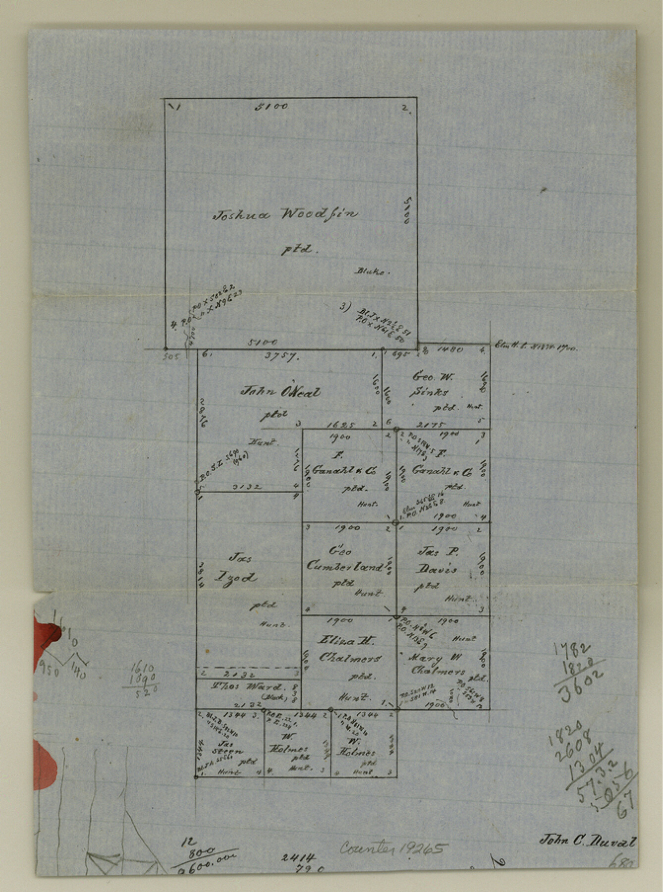
Cooke County Sketch File 21
[Sketch in northeast corner of county, around Joshua Woodfin survey]
-
Map/Doc
19265
-
Collection
General Map Collection
-
People and Organizations
John C. Duval (Surveyor/Engineer)
John C. Duval (Draftsman)
-
Counties
Cooke Grayson
-
Subjects
Surveying Sketch File
-
Height x Width
9.0 x 6.7 inches
22.9 x 17.0 cm
-
Medium
paper, manuscript
Part of: General Map Collection
Brazoria County NRC Article 33.136 Sketch 24

Print $24.00
Brazoria County NRC Article 33.136 Sketch 24
2025
Map/Doc 97504
Anderson County Working Sketch 3

Print $20.00
- Digital $50.00
Anderson County Working Sketch 3
Size 15.4 x 14.1 inches
Map/Doc 67002

[Right of Way & Track Map, The Texas & Pacific Ry. Co. Main Line]
![64689, [Right of Way & Track Map, The Texas & Pacific Ry. Co. Main Line], General Map Collection](https://historictexasmaps.com/wmedia_w700/maps/64689.tif.jpg)
Print $20.00
- Digital $50.00
[Right of Way & Track Map, The Texas & Pacific Ry. Co. Main Line]
Size 11.0 x 19.0 inches
Map/Doc 64689
Maps of Gulf Intracoastal Waterway, Texas - Sabine River to the Rio Grande and connecting waterways including ship channels

Print $20.00
- Digital $50.00
Maps of Gulf Intracoastal Waterway, Texas - Sabine River to the Rio Grande and connecting waterways including ship channels
1966
Size 14.6 x 22.3 inches
Map/Doc 61950
Angelina County Working Sketch 26

Print $40.00
- Digital $50.00
Angelina County Working Sketch 26
1954
Size 50.0 x 67.9 inches
Map/Doc 67108
Topographical Map of the Rio Grande, Sheet No. 23

Print $20.00
- Digital $50.00
Topographical Map of the Rio Grande, Sheet No. 23
1912
Map/Doc 89547
Dimmit County Sketch File 11b

Print $20.00
- Digital $50.00
Dimmit County Sketch File 11b
1909
Size 30.3 x 26.7 inches
Map/Doc 11340
Blanco County Sketch File 31

Print $4.00
- Digital $50.00
Blanco County Sketch File 31
Size 11.1 x 8.6 inches
Map/Doc 14629
San Patricio County Sketch File 15

Print $24.00
San Patricio County Sketch File 15
1879
Size 9.0 x 7.6 inches
Map/Doc 36051
Sectional Map No. 3 of the lands and of the line of the Texas & Pacific Ry. Co. in Reeves and parts of Tom Green, Pecos, Presidio & El Paso Cos.

Print $20.00
- Digital $50.00
Sectional Map No. 3 of the lands and of the line of the Texas & Pacific Ry. Co. in Reeves and parts of Tom Green, Pecos, Presidio & El Paso Cos.
1885
Size 24.2 x 18.9 inches
Map/Doc 4858
Caldwell County Sketch File 3

Print $4.00
- Digital $50.00
Caldwell County Sketch File 3
1872
Size 12.7 x 8.1 inches
Map/Doc 35827
You may also like
Stonewall County Working Sketch 30

Print $20.00
- Digital $50.00
Stonewall County Working Sketch 30
1982
Size 28.6 x 29.0 inches
Map/Doc 62337
[Galveston, Harrisburg & San Antonio through El Paso County]
![64010, [Galveston, Harrisburg & San Antonio through El Paso County], General Map Collection](https://historictexasmaps.com/wmedia_w700/maps/64010.tif.jpg)
Print $20.00
- Digital $50.00
[Galveston, Harrisburg & San Antonio through El Paso County]
1906
Size 13.4 x 33.9 inches
Map/Doc 64010
Travis County Sketch File 55

Print $20.00
- Digital $50.00
Travis County Sketch File 55
1945
Size 27.3 x 14.5 inches
Map/Doc 12471
No. 2 Chart of Corpus Christi Pass, Texas

Print $20.00
- Digital $50.00
No. 2 Chart of Corpus Christi Pass, Texas
1878
Size 18.3 x 27.3 inches
Map/Doc 73026
[Sketch for Mineral Applications 7410, 7411, 7412, 7413, 7712 - Kleberg County]
![65624, [Sketch for Mineral Applications 7410, 7411, 7412, 7413, 7712 - Kleberg County], General Map Collection](https://historictexasmaps.com/wmedia_w700/maps/65624-1.tif.jpg)
Print $40.00
- Digital $50.00
[Sketch for Mineral Applications 7410, 7411, 7412, 7413, 7712 - Kleberg County]
1977
Size 91.9 x 44.5 inches
Map/Doc 65624
General Highway Map, Jim Wells County, Texas

Print $20.00
General Highway Map, Jim Wells County, Texas
1961
Size 18.2 x 24.6 inches
Map/Doc 79543
Flight Mission No. CRC-4R, Frame 174, Chambers County

Print $20.00
- Digital $50.00
Flight Mission No. CRC-4R, Frame 174, Chambers County
1956
Size 18.6 x 22.3 inches
Map/Doc 84925
Galveston County Sketch File 59

Print $8.00
- Digital $50.00
Galveston County Sketch File 59
1977
Size 14.2 x 8.7 inches
Map/Doc 23607
Brazoria County NRC Article 33.136 Sketch 12

Print $26.00
- Digital $50.00
Brazoria County NRC Article 33.136 Sketch 12
2010
Size 21.0 x 34.0 inches
Map/Doc 93407
Starr County Working Sketch 8

Print $20.00
- Digital $50.00
Starr County Working Sketch 8
1939
Size 21.9 x 28.8 inches
Map/Doc 63924
Dallas County Boundary File 7 and 7a and 7b

Print $26.00
- Digital $50.00
Dallas County Boundary File 7 and 7a and 7b
Size 11.2 x 8.6 inches
Map/Doc 52278
Nueces County NRC Article 33.136 Location Key Sheet

Print $20.00
- Digital $50.00
Nueces County NRC Article 33.136 Location Key Sheet
1975
Size 27.0 x 23.0 inches
Map/Doc 88585