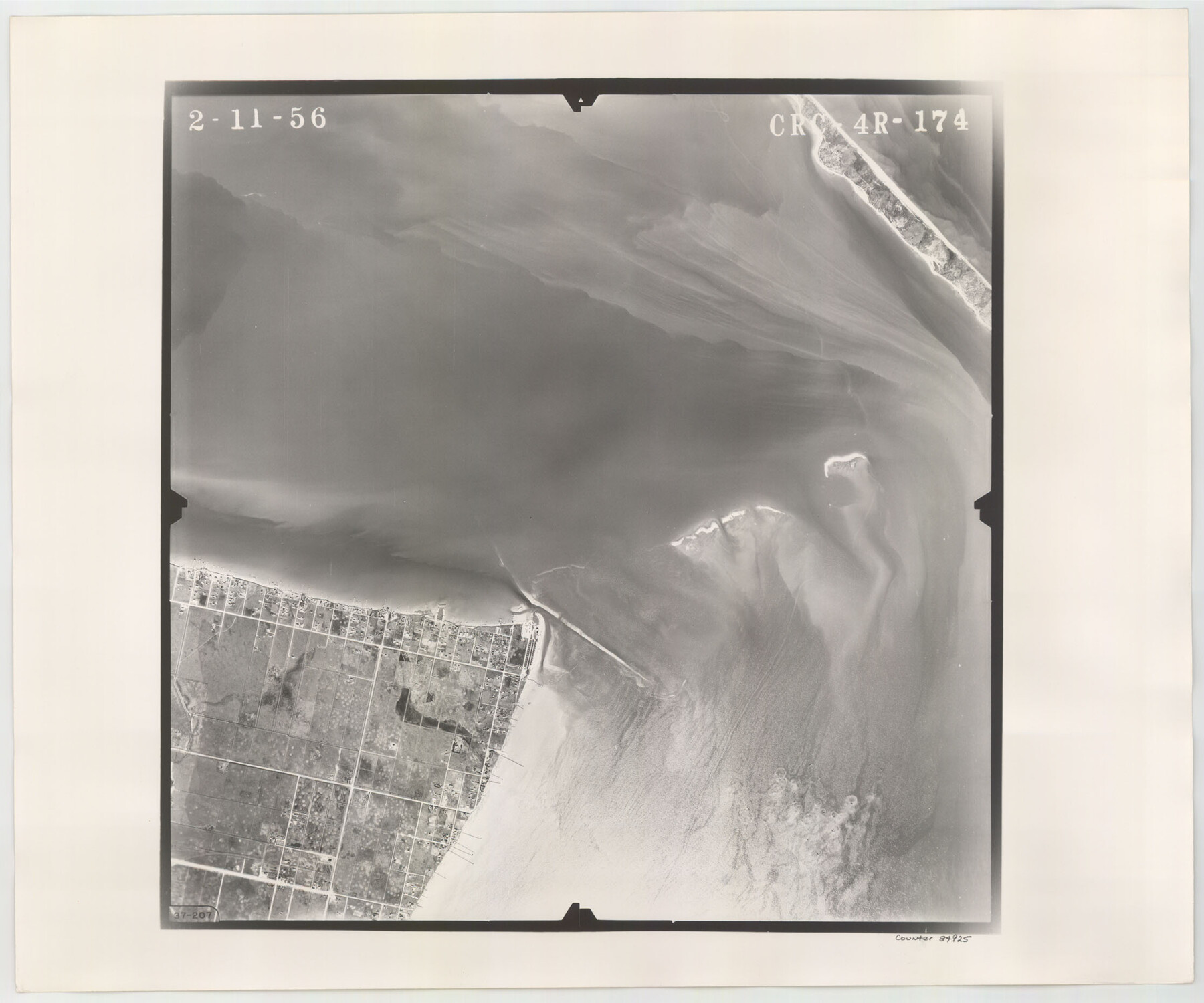
Flight Mission No. CRC-4R, Frame 174, Chambers County
CRC-4R-174
-
Map/Doc
84925
-
Collection
General Map Collection
-
Object Dates
1956/2/11 (Creation Date)
-
People and Organizations
U. S. Department of Agriculture (Publisher)
-
Counties
Chambers
-
Subjects
Aerial Photograph
-
Height x Width
18.6 x 22.3 inches
47.2 x 56.6 cm
-
Comments
Flown by Jack Ammann Photogrammetric Engineers, Inc. of San Antonio, Texas.
Part of: General Map Collection
Terry County Sketch File 13

Print $20.00
- Digital $50.00
Terry County Sketch File 13
Size 43.2 x 10.2 inches
Map/Doc 10397
Panola County Working Sketch 13

Print $40.00
- Digital $50.00
Panola County Working Sketch 13
1945
Map/Doc 71422
Liberty County Working Sketch 1

Print $20.00
- Digital $50.00
Liberty County Working Sketch 1
Size 26.5 x 29.7 inches
Map/Doc 70460
No. 2 Chart of Corpus Christi Pass, Texas

Print $20.00
- Digital $50.00
No. 2 Chart of Corpus Christi Pass, Texas
1878
Size 18.3 x 27.4 inches
Map/Doc 73019
Intracoastal Waterway, Houma, LA to Corpus Christi, TX

Print $5.00
- Digital $50.00
Intracoastal Waterway, Houma, LA to Corpus Christi, TX
Size 22.3 x 28.0 inches
Map/Doc 61914
Terrell County Sketch File 27

Print $10.00
- Digital $50.00
Terrell County Sketch File 27
1936
Size 8.7 x 11.3 inches
Map/Doc 37971
Maverick County Rolled Sketch 19

Print $20.00
- Digital $50.00
Maverick County Rolled Sketch 19
1955
Size 33.5 x 44.1 inches
Map/Doc 9494
Flight Mission No. CRC-3R, Frame 42, Chambers County

Print $20.00
- Digital $50.00
Flight Mission No. CRC-3R, Frame 42, Chambers County
1956
Size 18.8 x 22.4 inches
Map/Doc 84815
Crockett County Sketch File 27

Print $10.00
- Digital $50.00
Crockett County Sketch File 27
1883
Size 9.1 x 14.5 inches
Map/Doc 19717
Flight Mission No. CLL-13G, Frame 39, Willacy County

Print $20.00
- Digital $50.00
Flight Mission No. CLL-13G, Frame 39, Willacy County
1950
Size 18.4 x 18.2 inches
Map/Doc 87089
Dimmit County Working Sketch 30

Print $20.00
- Digital $50.00
Dimmit County Working Sketch 30
1957
Size 22.2 x 26.0 inches
Map/Doc 68691
Calhoun County Rolled Sketch 22

Print $20.00
- Digital $50.00
Calhoun County Rolled Sketch 22
Size 35.0 x 37.0 inches
Map/Doc 8552
You may also like
Val Verde County Sketch File 36

Print $20.00
- Digital $50.00
Val Verde County Sketch File 36
1937
Size 18.6 x 24.6 inches
Map/Doc 12577
Hartley County Sketch File 10

Print $57.00
- Digital $50.00
Hartley County Sketch File 10
Size 9.2 x 7.8 inches
Map/Doc 26099
Presidio County Working Sketch 83

Print $20.00
- Digital $50.00
Presidio County Working Sketch 83
1969
Size 21.5 x 24.8 inches
Map/Doc 71760
Uvalde County Working Sketch 65

Print $20.00
- Digital $50.00
Uvalde County Working Sketch 65
Size 34.8 x 43.0 inches
Map/Doc 69696
Texas, San Bernard River, Cedar Lakes

Print $40.00
- Digital $50.00
Texas, San Bernard River, Cedar Lakes
1933
Size 26.7 x 48.6 inches
Map/Doc 69993

Flight Mission No. DQN-5K, Frame 59, Calhoun County

Print $20.00
- Digital $50.00
Flight Mission No. DQN-5K, Frame 59, Calhoun County
1953
Size 18.7 x 22.3 inches
Map/Doc 84402
[Surveys along Elm Creek]
![347, [Surveys along Elm Creek], General Map Collection](https://historictexasmaps.com/wmedia_w700/maps/347.tif.jpg)
Print $2.00
- Digital $50.00
[Surveys along Elm Creek]
1846
Size 12.0 x 7.4 inches
Map/Doc 347
The Republic County of Bowie. June 24, 1841

Print $20.00
The Republic County of Bowie. June 24, 1841
2020
Size 19.5 x 21.7 inches
Map/Doc 96104
Martin County Sketch File 3

Print $19.00
- Digital $50.00
Martin County Sketch File 3
Size 7.4 x 8.6 inches
Map/Doc 30632
Reeves County Rolled Sketch 37

Print $20.00
- Digital $50.00
Reeves County Rolled Sketch 37
2017
Size 22.9 x 17.1 inches
Map/Doc 95203
Topographic Map of Texas and Oklahoma Boundary, Fort Augur Area

Print $20.00
Topographic Map of Texas and Oklahoma Boundary, Fort Augur Area
1924
Size 20.3 x 33.0 inches
Map/Doc 79753