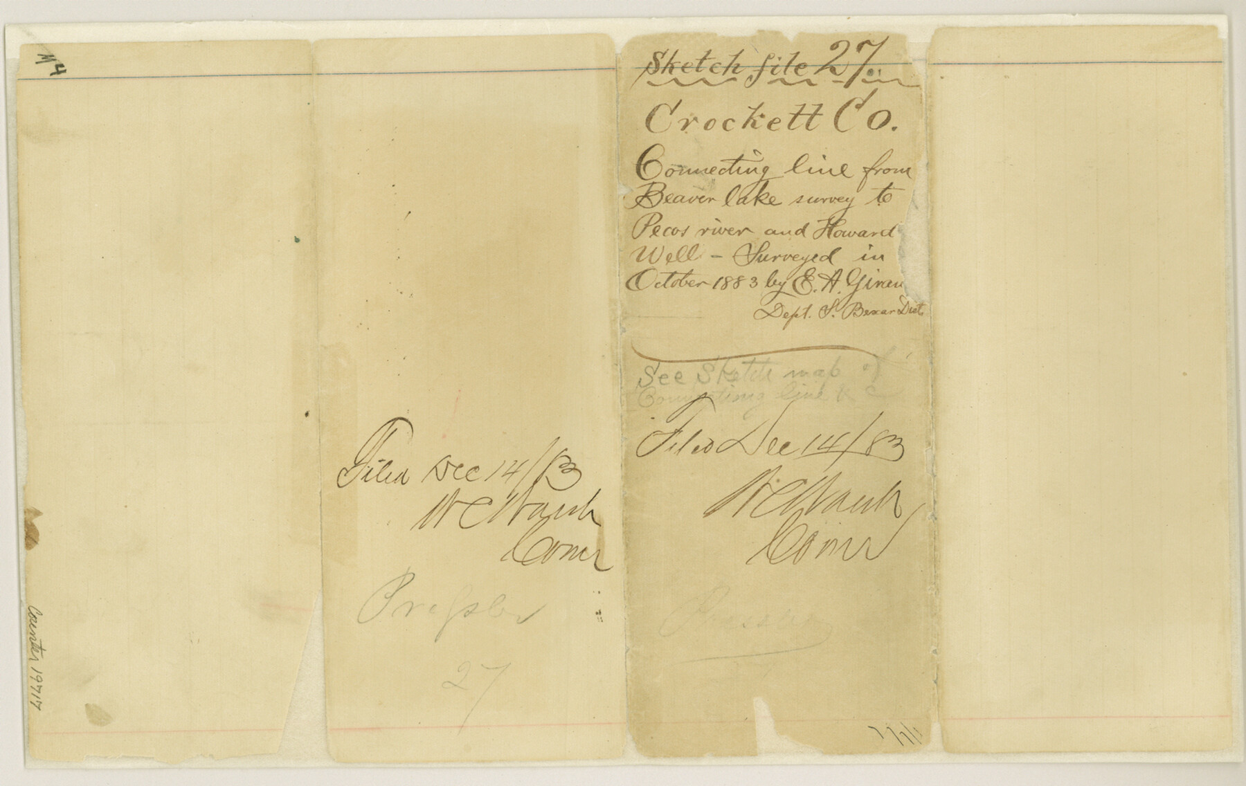
Crockett County Sketch File 27
[Connecting line from Beaver Lake survey to Pecos River and Howard's Well]
-
Map/Doc
19717
-
Collection
General Map Collection
-
Object Dates
1883 (Creation Date)
1883/12/14 (File Date)
1883 (Survey Date)
1883/11/22 (Survey Date)
-
People and Organizations
E.A. Giraud (Surveyor/Engineer)
Will H. Bonnell (Surveyor/Engineer)
-
Counties
Crockett
-
Subjects
Surveying Sketch File
-
Height x Width
9.1 x 14.5 inches
23.1 x 36.8 cm
-
Medium
paper, manuscript
-
Features
Beaver Lake
Pecos River
Howards Well
Part of: General Map Collection
Palo Pinto County Sketch File 25a

Print $6.00
- Digital $50.00
Palo Pinto County Sketch File 25a
Size 11.0 x 11.4 inches
Map/Doc 33417
Harris County Sketch File 69a

Print $20.00
- Digital $50.00
Harris County Sketch File 69a
1938
Size 19.4 x 21.3 inches
Map/Doc 11663
Lavaca County

Print $40.00
- Digital $50.00
Lavaca County
1946
Size 51.1 x 42.8 inches
Map/Doc 73216
Flight Mission No. CRE-2R, Frame 84, Jackson County

Print $20.00
- Digital $50.00
Flight Mission No. CRE-2R, Frame 84, Jackson County
1956
Size 16.1 x 15.9 inches
Map/Doc 85356

Coast Chart No. 212 - From Latitude 26° 33' to the Rio Grande, Texas

Print $20.00
- Digital $50.00
Coast Chart No. 212 - From Latitude 26° 33' to the Rio Grande, Texas
1886
Size 30.5 x 24.1 inches
Map/Doc 73504
Midland County Working Sketch 7

Print $20.00
- Digital $50.00
Midland County Working Sketch 7
1950
Size 34.6 x 28.3 inches
Map/Doc 70987
Gaines County Rolled Sketch 11

Print $20.00
- Digital $50.00
Gaines County Rolled Sketch 11
1939
Size 22.4 x 32.9 inches
Map/Doc 5931
[Beaumont, Sour Lake and Western Ry. Right of Way and Alignment - Frisco]
![64121, [Beaumont, Sour Lake and Western Ry. Right of Way and Alignment - Frisco], General Map Collection](https://historictexasmaps.com/wmedia_w700/maps/64121.tif.jpg)
Print $20.00
- Digital $50.00
[Beaumont, Sour Lake and Western Ry. Right of Way and Alignment - Frisco]
1910
Size 20.0 x 45.8 inches
Map/Doc 64121
La Salle County Sketch File 25

Print $4.00
- Digital $50.00
La Salle County Sketch File 25
Size 7.5 x 14.2 inches
Map/Doc 29549
Map of Roberts County

Print $40.00
- Digital $50.00
Map of Roberts County
1900
Size 45.3 x 50.0 inches
Map/Doc 3990
Culberson County Working Sketch 48

Print $40.00
- Digital $50.00
Culberson County Working Sketch 48
1972
Size 49.3 x 39.0 inches
Map/Doc 68502
You may also like
Webb County Rolled Sketch 5

Print $20.00
- Digital $50.00
Webb County Rolled Sketch 5
Size 43.2 x 23.0 inches
Map/Doc 8172
Nacogdoches County Sketch File 21

Print $20.00
- Digital $50.00
Nacogdoches County Sketch File 21
1837
Size 9.4 x 5.5 inches
Map/Doc 32286
Blanco County Rolled Sketch 17

Print $20.00
- Digital $50.00
Blanco County Rolled Sketch 17
Size 18.0 x 23.9 inches
Map/Doc 5153
Photo Index of Texas Coast - Sheet 6 of 6

Print $20.00
- Digital $50.00
Photo Index of Texas Coast - Sheet 6 of 6
1954
Size 20.0 x 24.0 inches
Map/Doc 83444
Culberson County Sketch File 25

Print $6.00
- Digital $50.00
Culberson County Sketch File 25
Size 11.2 x 8.8 inches
Map/Doc 20259
University of Texas System University Lands

Print $20.00
- Digital $50.00
University of Texas System University Lands
Size 17.8 x 23.4 inches
Map/Doc 93245
Texas Exhibit No. 84 - [Texas and Oklahoma Red River Boundary]
![75261, Texas Exhibit No. 84 - [Texas and Oklahoma Red River Boundary], General Map Collection](https://historictexasmaps.com/wmedia_w700/maps/75261.tif.jpg)
Print $40.00
- Digital $50.00
Texas Exhibit No. 84 - [Texas and Oklahoma Red River Boundary]
1921
Size 35.6 x 52.3 inches
Map/Doc 75261
Flight Mission No. CRC-2R, Frame 201, Chambers County

Print $20.00
- Digital $50.00
Flight Mission No. CRC-2R, Frame 201, Chambers County
1956
Size 18.5 x 22.3 inches
Map/Doc 84779
Hood County Rolled Sketch 1

Print $20.00
- Digital $50.00
Hood County Rolled Sketch 1
1946
Size 31.9 x 38.6 inches
Map/Doc 9177
[Map of Terrell County]
![4074, [Map of Terrell County], General Map Collection](https://historictexasmaps.com/wmedia_w700/maps/4074.tif.jpg)
Print $20.00
- Digital $50.00
[Map of Terrell County]
Size 38.0 x 24.0 inches
Map/Doc 4074
Terrell County Rolled Sketch 46

Print $20.00
- Digital $50.00
Terrell County Rolled Sketch 46
1958
Size 16.1 x 14.6 inches
Map/Doc 7948
Parker County Sketch File 5

Print $4.00
- Digital $50.00
Parker County Sketch File 5
1858
Size 8.1 x 8.2 inches
Map/Doc 33528