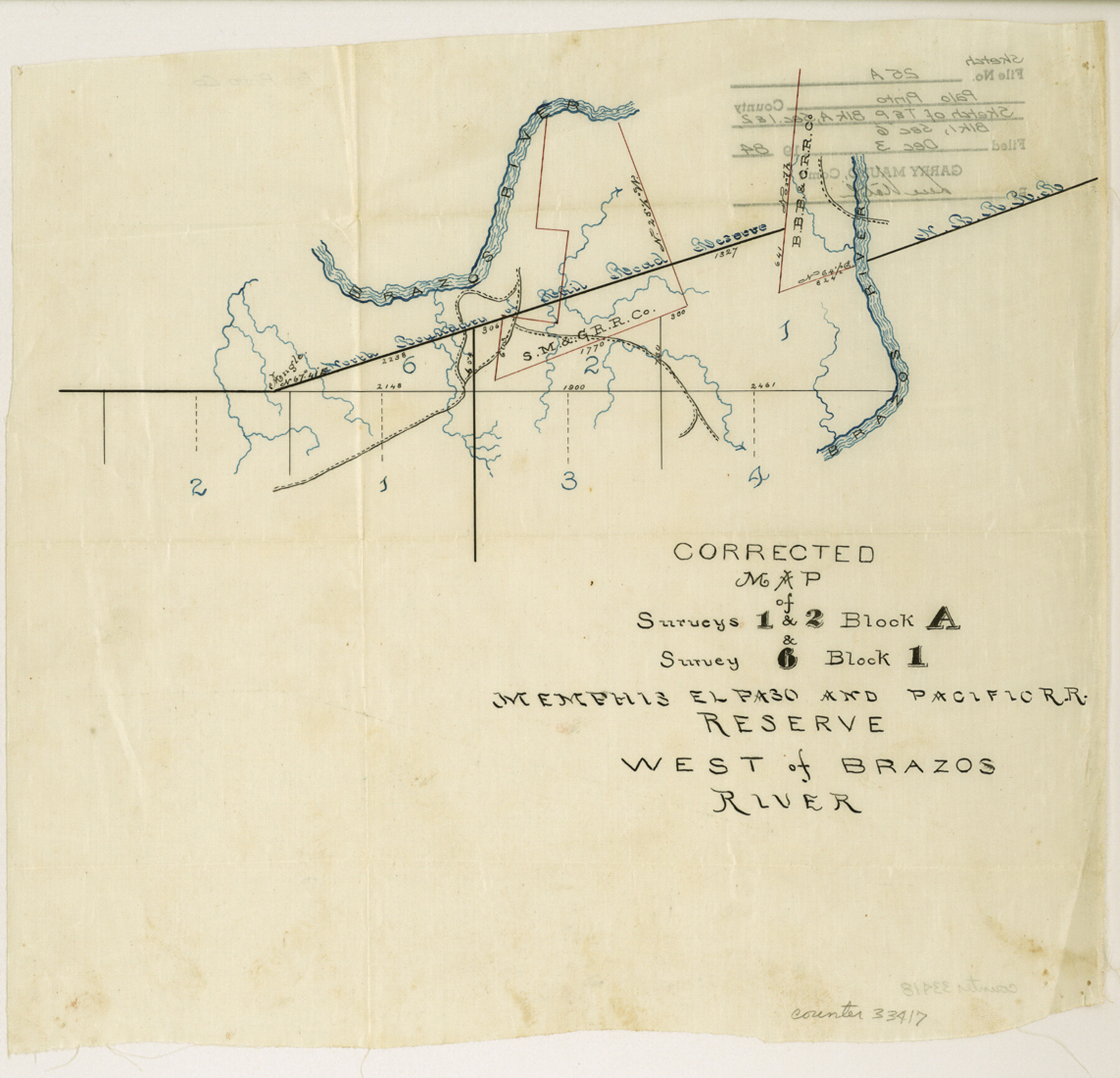
Palo Pinto County Sketch File 25a
Corrected Map of Surveys 1 and 2, Block A and Survey 6 Block 1, Memphis, El Paso and Pacific RR. Reserve west of Brazos River
-
Map/Doc
33417
-
Collection
General Map Collection
-
Object Dates
12/3/1984 (File Date)
-
Counties
Palo Pinto
-
Subjects
Surveying Sketch File
-
Height x Width
11.0 x 11.4 inches
27.9 x 29.0 cm
-
Medium
paper, manuscript
-
Features
Brazos River
Part of: General Map Collection
Hutchinson County Sketch File 26

Print $20.00
- Digital $50.00
Hutchinson County Sketch File 26
1920
Size 18.6 x 17.4 inches
Map/Doc 11816
Flight Mission No. DIX-8P, Frame 57, Aransas County

Print $20.00
- Digital $50.00
Flight Mission No. DIX-8P, Frame 57, Aransas County
1956
Size 18.7 x 22.4 inches
Map/Doc 83888
Texas Coordinate File 6

Print $40.00
- Digital $50.00
Texas Coordinate File 6
1946
Size 23.7 x 49.0 inches
Map/Doc 75314
Floyd County Working Sketch 9

Print $20.00
- Digital $50.00
Floyd County Working Sketch 9
1952
Size 31.5 x 35.9 inches
Map/Doc 69188

Haskell County Sketch File 4

Print $20.00
- Digital $50.00
Haskell County Sketch File 4
Size 17.7 x 18.6 inches
Map/Doc 11739
[Jose Pineda grant]
![123, [Jose Pineda grant], General Map Collection](https://historictexasmaps.com/wmedia_w700/maps/123.tif.jpg)
Print $2.00
- Digital $50.00
[Jose Pineda grant]
1846
Size 13.6 x 7.7 inches
Map/Doc 123
Flight Mission No. BQR-5K, Frame 74, Brazoria County

Print $20.00
- Digital $50.00
Flight Mission No. BQR-5K, Frame 74, Brazoria County
1952
Size 18.8 x 22.4 inches
Map/Doc 84019
Polk County Working Sketch 18

Print $20.00
- Digital $50.00
Polk County Working Sketch 18
1949
Size 25.4 x 23.3 inches
Map/Doc 71633
Stonewall County Sketch File 22

Print $20.00
- Digital $50.00
Stonewall County Sketch File 22
1937
Size 18.8 x 23.1 inches
Map/Doc 12368
Atascosa County Boundary File 3

Print $18.00
- Digital $50.00
Atascosa County Boundary File 3
Size 8.7 x 8.5 inches
Map/Doc 50168
Flight Mission No. BRA-16M, Frame 119, Jefferson County

Print $20.00
- Digital $50.00
Flight Mission No. BRA-16M, Frame 119, Jefferson County
1953
Size 18.6 x 22.5 inches
Map/Doc 85729
You may also like
Flight Mission No. DIX-7P, Frame 22, Aransas County

Print $20.00
- Digital $50.00
Flight Mission No. DIX-7P, Frame 22, Aransas County
1956
Size 18.7 x 22.5 inches
Map/Doc 83874
Ochiltree County Boundary File 10

Print $24.00
- Digital $50.00
Ochiltree County Boundary File 10
Size 11.2 x 8.7 inches
Map/Doc 57728
[Surveys along the Liberty and Hardin County line]
![295, [Surveys along the Liberty and Hardin County line], General Map Collection](https://historictexasmaps.com/wmedia_w700/maps/295.tif.jpg)
Print $2.00
- Digital $50.00
[Surveys along the Liberty and Hardin County line]
1847
Size 13.5 x 7.7 inches
Map/Doc 295
Burleson County Working Sketch 24

Print $20.00
- Digital $50.00
Burleson County Working Sketch 24
1980
Size 18.5 x 35.9 inches
Map/Doc 67743
Stonewall County Sketch File B2

Print $20.00
- Digital $50.00
Stonewall County Sketch File B2
1902
Size 25.8 x 25.0 inches
Map/Doc 12377
Kerr County Boundary File 1

Print $4.00
- Digital $50.00
Kerr County Boundary File 1
Size 12.7 x 8.1 inches
Map/Doc 55982
The Railroad System of Texas on September 1st, 1887

Print $20.00
- Digital $50.00
The Railroad System of Texas on September 1st, 1887
1887
Size 22.2 x 28.2 inches
Map/Doc 3036
Railroad Track Map, H&TCRRCo., Falls County, Texas

Print $4.00
- Digital $50.00
Railroad Track Map, H&TCRRCo., Falls County, Texas
1918
Size 11.7 x 18.3 inches
Map/Doc 62853
Map of the Texas & Pacific Railway and connections

Print $20.00
- Digital $50.00
Map of the Texas & Pacific Railway and connections
1911
Size 18.1 x 37.1 inches
Map/Doc 95770
Zapata County Working Sketch 19

Print $40.00
- Digital $50.00
Zapata County Working Sketch 19
1976
Size 41.2 x 55.5 inches
Map/Doc 62070
Menard County Boundary File 1a

Print $8.00
- Digital $50.00
Menard County Boundary File 1a
Size 12.7 x 8.2 inches
Map/Doc 57042
Van Zandt County Boundary File 2

Print $32.00
- Digital $50.00
Van Zandt County Boundary File 2
Size 13.0 x 8.1 inches
Map/Doc 59633