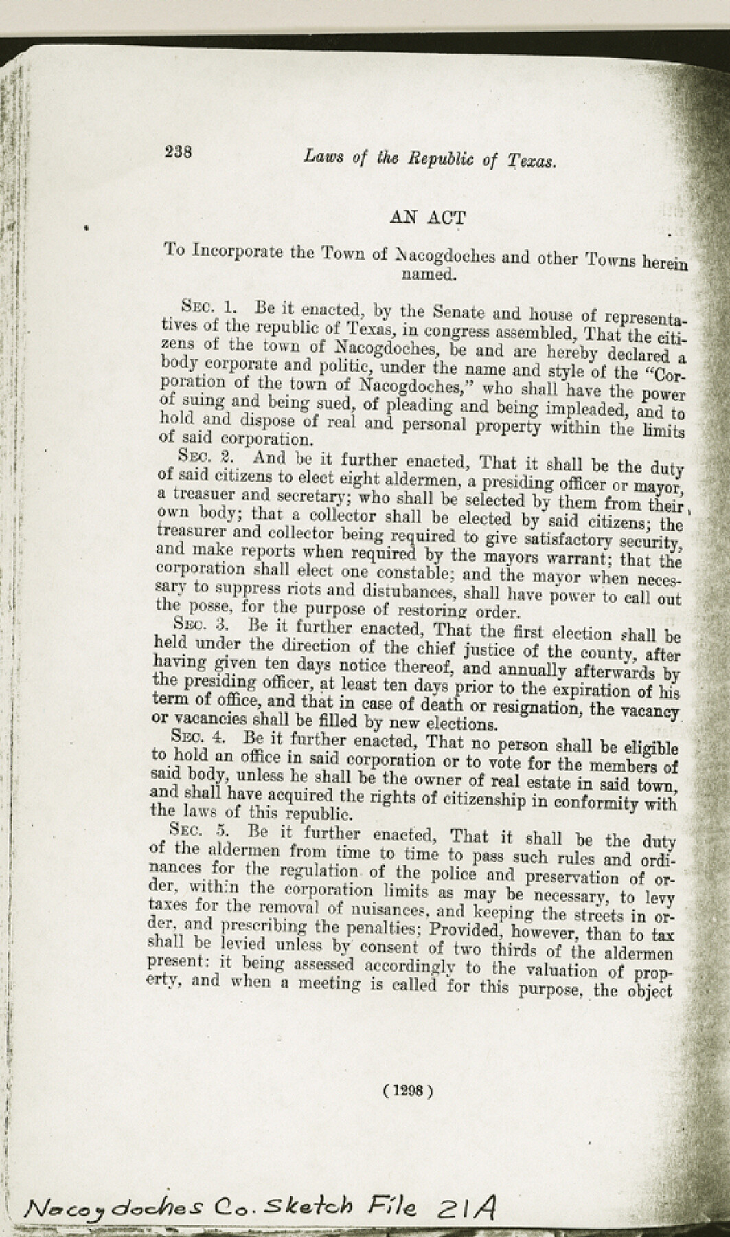
Nacogdoches County Sketch File 21
[Copies of four acts related to the Incorporation of the town of Nacogdoches]
-
Map/Doc
32286
-
Collection
General Map Collection
-
Object Dates
1837 (Creation Date)
1850 (Creation Date)
1848 (Creation Date)
1852 (Creation Date)
-
Counties
Nacogdoches
-
Subjects
Surveying Sketch File
-
Height x Width
9.4 x 5.5 inches
23.9 x 14.0 cm
-
Medium
paper, photocopy
-
Features
Nacogdoches
Bridget's Bayou
Lanana Bayou
James H. Starr
John Noblett
Part of: General Map Collection
Newton County Working Sketch 38

Print $20.00
- Digital $50.00
Newton County Working Sketch 38
1961
Size 36.8 x 29.2 inches
Map/Doc 71284
Yoakum County

Print $20.00
- Digital $50.00
Yoakum County
1932
Size 45.6 x 33.6 inches
Map/Doc 95681
Comanche County Working Sketch 29

Print $20.00
- Digital $50.00
Comanche County Working Sketch 29
1986
Size 29.3 x 37.8 inches
Map/Doc 68163
Throckmorton County Sketch File 14

Print $16.00
- Digital $50.00
Throckmorton County Sketch File 14
2004
Size 11.0 x 8.5 inches
Map/Doc 82481
Hamilton County Sketch File 23

Print $20.00
- Digital $50.00
Hamilton County Sketch File 23
1955
Size 25.8 x 24.8 inches
Map/Doc 11618
Brewster County Rolled Sketch 83

Print $20.00
- Digital $50.00
Brewster County Rolled Sketch 83
1946
Size 43.4 x 43.7 inches
Map/Doc 8495
Llano County Working Sketch Graphic Index

Print $20.00
- Digital $50.00
Llano County Working Sketch Graphic Index
1943
Size 43.7 x 42.6 inches
Map/Doc 76624
Bell County Working Sketch 4

Print $20.00
- Digital $50.00
Bell County Working Sketch 4
1942
Size 26.9 x 21.0 inches
Map/Doc 67344
Harrison County

Print $20.00
- Digital $50.00
Harrison County
1920
Size 47.7 x 42.9 inches
Map/Doc 4972
Lavaca County

Print $40.00
- Digital $50.00
Lavaca County
1946
Size 51.1 x 42.8 inches
Map/Doc 73216
[Map of Tom Green County]
![4085, [Map of Tom Green County], General Map Collection](https://historictexasmaps.com/wmedia_w700/maps/4085-2.tif.jpg)
Print $20.00
- Digital $50.00
[Map of Tom Green County]
Size 23.9 x 36.5 inches
Map/Doc 4085
Erath County Working Sketch 10

Print $20.00
- Digital $50.00
Erath County Working Sketch 10
1948
Size 28.7 x 24.5 inches
Map/Doc 69091
You may also like
Moore County Sketch File 3

Print $20.00
- Digital $50.00
Moore County Sketch File 3
Size 17.2 x 19.3 inches
Map/Doc 42126
Swisher County Rolled Sketch 4

Print $20.00
- Digital $50.00
Swisher County Rolled Sketch 4
1904
Size 16.2 x 18.0 inches
Map/Doc 7905
North Part of Brewster Co.

Print $20.00
- Digital $50.00
North Part of Brewster Co.
1956
Size 40.0 x 37.9 inches
Map/Doc 77220
Jeff Davis County Rolled Sketch 43

Print $20.00
- Digital $50.00
Jeff Davis County Rolled Sketch 43
2002
Size 24.2 x 24.4 inches
Map/Doc 78648
Travis County Sketch File 25

Print $4.00
- Digital $50.00
Travis County Sketch File 25
1876
Size 12.7 x 8.5 inches
Map/Doc 38334
Map of the New England or Eastern States (Inset 1: Map of New Brunswick, Nova Scotia and Newfoundland / Inset 2: Vicinity of Boston and Providence / Inset 3: Vicinity of New Haven and Hartford)

Print $20.00
- Digital $50.00
Map of the New England or Eastern States (Inset 1: Map of New Brunswick, Nova Scotia and Newfoundland / Inset 2: Vicinity of Boston and Providence / Inset 3: Vicinity of New Haven and Hartford)
1844
Size 17.8 x 11.8 inches
Map/Doc 93495
Kaufman County

Print $40.00
- Digital $50.00
Kaufman County
1942
Size 48.7 x 39.5 inches
Map/Doc 73202
Galveston County Sketch File 64

Print $44.00
- Digital $50.00
Galveston County Sketch File 64
1984
Size 31.5 x 25.5 inches
Map/Doc 11542


Goliad County Sketch File 1

Print $24.00
- Digital $50.00
Goliad County Sketch File 1
1857
Size 12.5 x 7.5 inches
Map/Doc 24211
Flight Mission No. CGI-3N, Frame 179, Cameron County

Print $20.00
- Digital $50.00
Flight Mission No. CGI-3N, Frame 179, Cameron County
1954
Size 18.6 x 22.2 inches
Map/Doc 84643