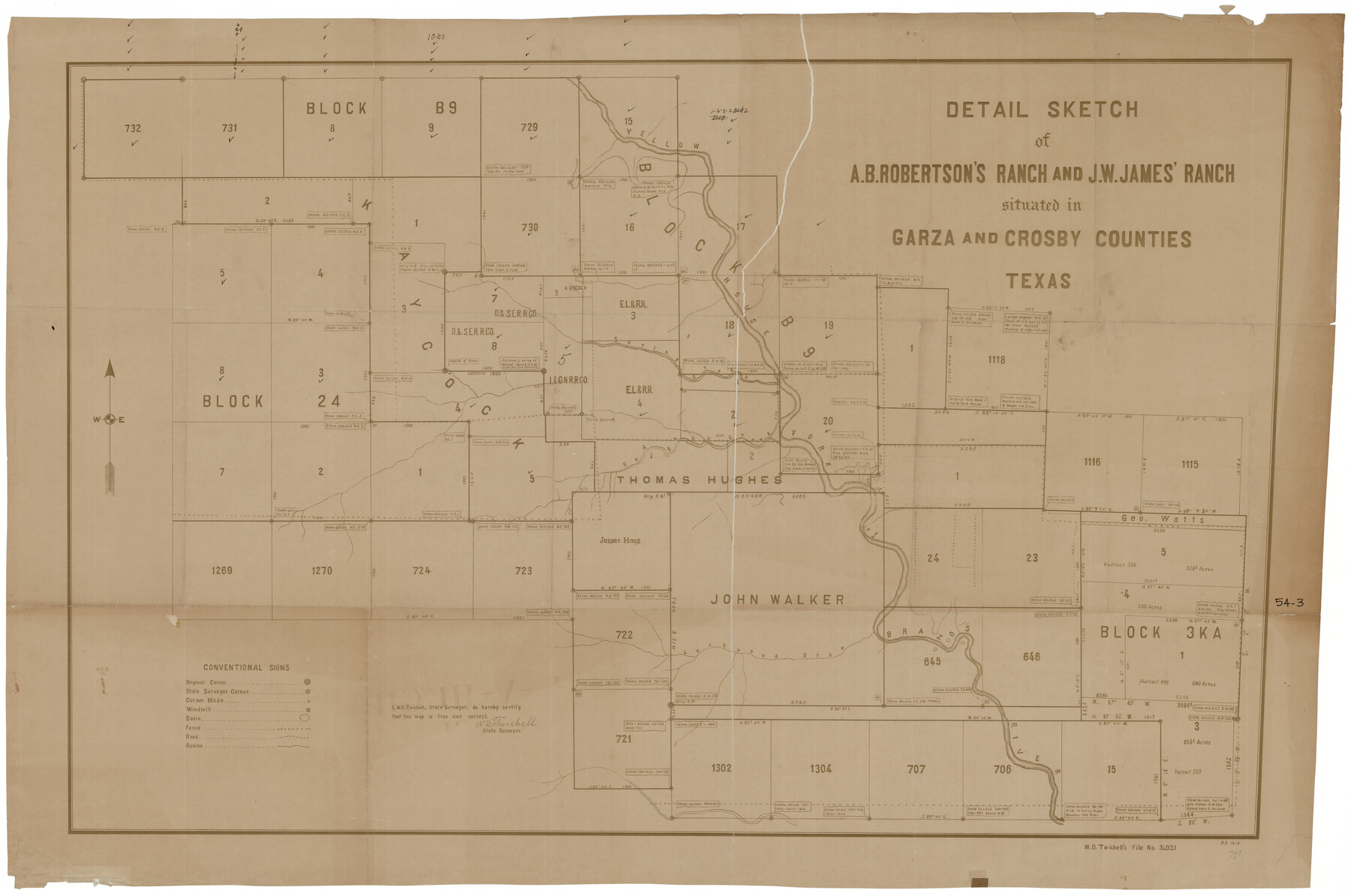
Detail Sketch of A.B. Robertson's Ranch and J.W. James' Ranch situated in Garza and Crosby Counties, Texas
54-3
-
Map/Doc
93030
-
Collection
Twichell Survey Records
-
People and Organizations
W.D. Twichell (Surveyor/Engineer)
-
Counties
Crosby Garza
-
Height x Width
51.8 x 34.1 inches
131.6 x 86.6 cm
Part of: Twichell Survey Records
[Worksheets related to the Wilson Strickland survey and vicinity]
![91265, [Vicinity and related to the Wilson Strickland Survey], Twichell Survey Records](https://historictexasmaps.com/wmedia_w700/maps/91265-1.tif.jpg)
Print $20.00
- Digital $50.00
[Worksheets related to the Wilson Strickland survey and vicinity]
Size 39.0 x 11.6 inches
Map/Doc 91265
Part of Garza, Crosby, Lynn and Lubbock Counties

Print $20.00
- Digital $50.00
Part of Garza, Crosby, Lynn and Lubbock Counties
1912
Size 24.6 x 19.8 inches
Map/Doc 90907
[Sketch of part of G. & M. Block 5]
![93077, [Sketch of part of G. & M. Block 5], Twichell Survey Records](https://historictexasmaps.com/wmedia_w700/maps/93077-1.tif.jpg)
Print $3.00
- Digital $50.00
[Sketch of part of G. & M. Block 5]
Size 17.7 x 9.4 inches
Map/Doc 93077
Progressive Military Map of the United States, Southern Department, Sheet 403N, Comstock

Print $20.00
- Digital $50.00
Progressive Military Map of the United States, Southern Department, Sheet 403N, Comstock
1916
Size 35.0 x 23.9 inches
Map/Doc 92062
Crockett County

Print $20.00
- Digital $50.00
Crockett County
1920
Size 44.8 x 32.9 inches
Map/Doc 92548
[Part of Connected map of Stephen F. Austin's Colony on file at the GLO]
![90119, [Part of Connected map of Stephen F. Austin's Colony on file at the GLO], Twichell Survey Records](https://historictexasmaps.com/wmedia_w700/maps/90119-1.tif.jpg)
Print $20.00
- Digital $50.00
[Part of Connected map of Stephen F. Austin's Colony on file at the GLO]
1923
Size 18.5 x 18.1 inches
Map/Doc 90119
[M. B. & B. Blks. A, B & C near Coyote Lake]
![90249, [M. B. & B. Blks. A, B & C near Coyote Lake], Twichell Survey Records](https://historictexasmaps.com/wmedia_w700/maps/90249-1.tif.jpg)
Print $20.00
- Digital $50.00
[M. B. & B. Blks. A, B & C near Coyote Lake]
Size 15.4 x 23.3 inches
Map/Doc 90249
[Part of Block D7]
![91944, [Part of Block D7], Twichell Survey Records](https://historictexasmaps.com/wmedia_w700/maps/91944-1.tif.jpg)
Print $20.00
- Digital $50.00
[Part of Block D7]
Size 36.5 x 18.8 inches
Map/Doc 91944
George M. Slaughter Block Hockley and Cochran Counties, Texas

Print $20.00
- Digital $50.00
George M. Slaughter Block Hockley and Cochran Counties, Texas
1929
Size 14.1 x 25.2 inches
Map/Doc 92238
[Sections 77-114, Block 47 and part of G. & M. Blocks 2 and 3]
![91827, [Sections 77-114, Block 47 and part of G. & M. Blocks 2 and 3], Twichell Survey Records](https://historictexasmaps.com/wmedia_w700/maps/91827-1.tif.jpg)
Print $20.00
- Digital $50.00
[Sections 77-114, Block 47 and part of G. & M. Blocks 2 and 3]
Size 38.1 x 19.8 inches
Map/Doc 91827
[LIT Ranch, Gunter & Munson surveys 52-55, Canadian River Meander]
![93011, [LIT Ranch, Gunter & Munson surveys 52-55, Canadian River Meander], Twichell Survey Records](https://historictexasmaps.com/wmedia_w700/maps/93011-1.tif.jpg)
Print $20.00
- Digital $50.00
[LIT Ranch, Gunter & Munson surveys 52-55, Canadian River Meander]
Size 18.4 x 12.8 inches
Map/Doc 93011
[T. & P. Block 35, Townships 1N - 5N]
![93138, [T. & P. Block 35, Townships 1N - 5N], Twichell Survey Records](https://historictexasmaps.com/wmedia_w700/maps/93138-1.tif.jpg)
Print $40.00
- Digital $50.00
[T. & P. Block 35, Townships 1N - 5N]
Size 23.8 x 87.2 inches
Map/Doc 93138
You may also like
Crockett County Rolled Sketch 19
Print $40.00
- Digital $50.00
Crockett County Rolled Sketch 19
1901
Size 28.2 x 64.2 inches
Map/Doc 8691
General Highway Map. Detail of Cities and Towns in Orange County, Texas [Orange and vicinity]
![79622, General Highway Map. Detail of Cities and Towns in Orange County, Texas [Orange and vicinity], Texas State Library and Archives](https://historictexasmaps.com/wmedia_w700/maps/79622.tif.jpg)
Print $20.00
General Highway Map. Detail of Cities and Towns in Orange County, Texas [Orange and vicinity]
1961
Size 18.1 x 24.4 inches
Map/Doc 79622

Gaines County Working Sketch 11

Print $40.00
- Digital $50.00
Gaines County Working Sketch 11
1953
Size 68.4 x 33.4 inches
Map/Doc 69311
Flight Mission No. DAG-23K, Frame 172, Matagorda County

Print $20.00
- Digital $50.00
Flight Mission No. DAG-23K, Frame 172, Matagorda County
1953
Size 18.6 x 16.0 inches
Map/Doc 86510
Current Miscellaneous File 86

Print $6.00
- Digital $50.00
Current Miscellaneous File 86
Size 11.2 x 8.8 inches
Map/Doc 74240
[Surveys along the Red River]
![5, [Surveys along the Red River], General Map Collection](https://historictexasmaps.com/wmedia_w700/maps/5.tif.jpg)
Print $2.00
- Digital $50.00
[Surveys along the Red River]
Size 14.1 x 5.6 inches
Map/Doc 5

[Beaumont, Sour Lake and Western Ry. Right of Way and Alignment - Frisco]
![64121, [Beaumont, Sour Lake and Western Ry. Right of Way and Alignment - Frisco], General Map Collection](https://historictexasmaps.com/wmedia_w700/maps/64121.tif.jpg)
Print $20.00
- Digital $50.00
[Beaumont, Sour Lake and Western Ry. Right of Way and Alignment - Frisco]
1910
Size 20.0 x 45.8 inches
Map/Doc 64121
Oldham and Hartley Counties Sketch

Print $20.00
- Digital $50.00
Oldham and Hartley Counties Sketch
1906
Size 16.1 x 17.1 inches
Map/Doc 90671
Edwards County Sketch File 46

Print $26.00
- Digital $50.00
Edwards County Sketch File 46
1954
Size 11.3 x 8.7 inches
Map/Doc 21792
Midland County Working Sketch 22

Print $40.00
- Digital $50.00
Midland County Working Sketch 22
1956
Size 97.0 x 43.1 inches
Map/Doc 71003