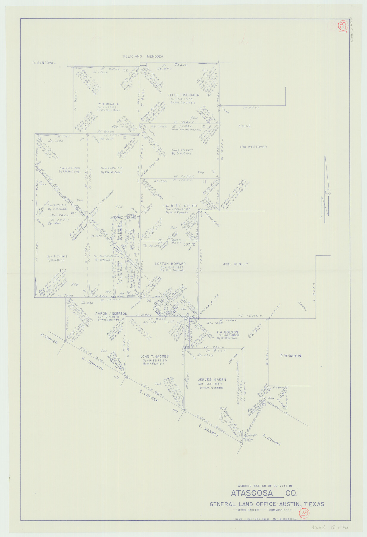
Atascosa County Working Sketch 28
Working Sketch of Surveys in Atascosa County
-
Map/Doc
67224
-
Collection
General Map Collection
-
Object Dates
5/6/1968 (Creation Date)
-
People and Organizations
Jerry Sadler (GLO Commissioner)
Herbert H. Ulbricht (Draftsman)
-
Counties
Atascosa
-
Subjects
Surveying Working Sketch
-
Height x Width
38.5 x 26.3 inches
97.8 x 66.8 cm
-
Scale
1" = 200 varas
-
Comments
Surveys located about 15 miles North 20 degrees West of Jourdanton, Texas.
Part of: General Map Collection
Garza County Rolled Sketch 11 & 11A

Print $31.00
- Digital $50.00
Garza County Rolled Sketch 11 & 11A
1915
Size 10.3 x 15.5 inches
Map/Doc 45214
Parker County Sketch File 31

Print $6.00
- Digital $50.00
Parker County Sketch File 31
1877
Size 9.9 x 9.8 inches
Map/Doc 33572
Kimble County Working Sketch 60

Print $20.00
- Digital $50.00
Kimble County Working Sketch 60
1964
Size 43.8 x 38.2 inches
Map/Doc 70128
[Sketches in McMullen County, San Patricio District]
![69747, [Sketches in McMullen County, San Patricio District], General Map Collection](https://historictexasmaps.com/wmedia_w700/maps/69747.tif.jpg)
Print $2.00
- Digital $50.00
[Sketches in McMullen County, San Patricio District]
1842
Size 10.5 x 8.0 inches
Map/Doc 69747
Gregg County Working Sketch 8

Print $20.00
- Digital $50.00
Gregg County Working Sketch 8
1936
Size 26.0 x 23.3 inches
Map/Doc 63274
Kinney County Working Sketch 15

Print $20.00
- Digital $50.00
Kinney County Working Sketch 15
1946
Size 24.7 x 13.6 inches
Map/Doc 70197

Crockett County Rolled Sketch 1

Print $40.00
- Digital $50.00
Crockett County Rolled Sketch 1
1888
Size 36.5 x 61.1 inches
Map/Doc 76144
Texas Gulf Coast Map from the Sabine River to the Rio Grande as subdivided for mineral development

Print $40.00
- Digital $50.00
Texas Gulf Coast Map from the Sabine River to the Rio Grande as subdivided for mineral development
1948
Size 48.9 x 38.0 inches
Map/Doc 2910
Jefferson Co.

Print $40.00
- Digital $50.00
Jefferson Co.
1978
Size 48.2 x 42.7 inches
Map/Doc 73196
Menard County Sketch File 30

Print $4.00
- Digital $50.00
Menard County Sketch File 30
1977
Size 14.3 x 8.6 inches
Map/Doc 31571
Henderson County Boundary File 3a

Print $30.00
- Digital $50.00
Henderson County Boundary File 3a
Size 14.4 x 8.9 inches
Map/Doc 54685
You may also like
St. Louis Southwestern Railway of Texas

Print $20.00
- Digital $50.00
St. Louis Southwestern Railway of Texas
1906
Size 22.5 x 30.5 inches
Map/Doc 64449
[Location Survey of the Southern Kansas Railway, Kiowa Extension from a point in Drake's Location, in Indian Territory 100 miles from south line of Kansas, continuing up Wolf Creek and South Canadian River to Cottonwood Creek in Hutchinson County]
![88843, [Location Survey of the Southern Kansas Railway, Kiowa Extension from a point in Drake's Location, in Indian Territory 100 miles from south line of Kansas, continuing up Wolf Creek and South Canadian River to Cottonwood Creek in Hutchinson County], General Map Collection](https://historictexasmaps.com/wmedia_w700/maps/88843.tif.jpg)
Print $20.00
- Digital $50.00
[Location Survey of the Southern Kansas Railway, Kiowa Extension from a point in Drake's Location, in Indian Territory 100 miles from south line of Kansas, continuing up Wolf Creek and South Canadian River to Cottonwood Creek in Hutchinson County]
1886
Size 39.0 x 40.0 inches
Map/Doc 88843
Harris County Rolled Sketch 88

Print $20.00
- Digital $50.00
Harris County Rolled Sketch 88
1937
Size 34.9 x 22.7 inches
Map/Doc 6126
Coryell County Working Sketch 14

Print $20.00
- Digital $50.00
Coryell County Working Sketch 14
1950
Size 19.4 x 17.5 inches
Map/Doc 68221
[Blocks C, M and B, north of Morris County School Land]
![90493, [Blocks C, M and B, north of Morris County School Land], Twichell Survey Records](https://historictexasmaps.com/wmedia_w700/maps/90493-1.tif.jpg)
Print $20.00
- Digital $50.00
[Blocks C, M and B, north of Morris County School Land]
Size 21.0 x 14.2 inches
Map/Doc 90493
Crockett County Rolled Sketch 88G

Print $40.00
- Digital $50.00
Crockett County Rolled Sketch 88G
1973
Size 42.7 x 57.3 inches
Map/Doc 8732
Ward County Working Sketch 53

Print $40.00
- Digital $50.00
Ward County Working Sketch 53
1982
Size 37.0 x 53.4 inches
Map/Doc 72359
Flight Mission No. BQR-14K, Frame 36, Brazoria County

Print $20.00
- Digital $50.00
Flight Mission No. BQR-14K, Frame 36, Brazoria County
1952
Size 18.6 x 22.3 inches
Map/Doc 84093
Andrews County Rolled Sketch 36

Print $20.00
- Digital $50.00
Andrews County Rolled Sketch 36
Size 22.1 x 18.6 inches
Map/Doc 77178
[Sketch showing the area around the state line in Roberts and Clay Counties, along the north bank of the Canadian River]
![91762, [Sketch showing the area around the state line in Roberts and Clay Counties, along the north bank of the Canadian River], Twichell Survey Records](https://historictexasmaps.com/wmedia_w700/maps/91762-1.tif.jpg)
Print $20.00
- Digital $50.00
[Sketch showing the area around the state line in Roberts and Clay Counties, along the north bank of the Canadian River]
1901
Size 14.3 x 12.7 inches
Map/Doc 91762
Upshur County Sketch File 9

Print $4.00
- Digital $50.00
Upshur County Sketch File 9
1847
Size 8.4 x 10.3 inches
Map/Doc 38748
I. & G. N. - International and Great Northern R.R. - International Route - Galveston, Ft. Worth, Waco, Houston, Austin, Laredo, San Antonio

Print $20.00
- Digital $50.00
I. & G. N. - International and Great Northern R.R. - International Route - Galveston, Ft. Worth, Waco, Houston, Austin, Laredo, San Antonio
1905
Size 23.5 x 15.8 inches
Map/Doc 95778