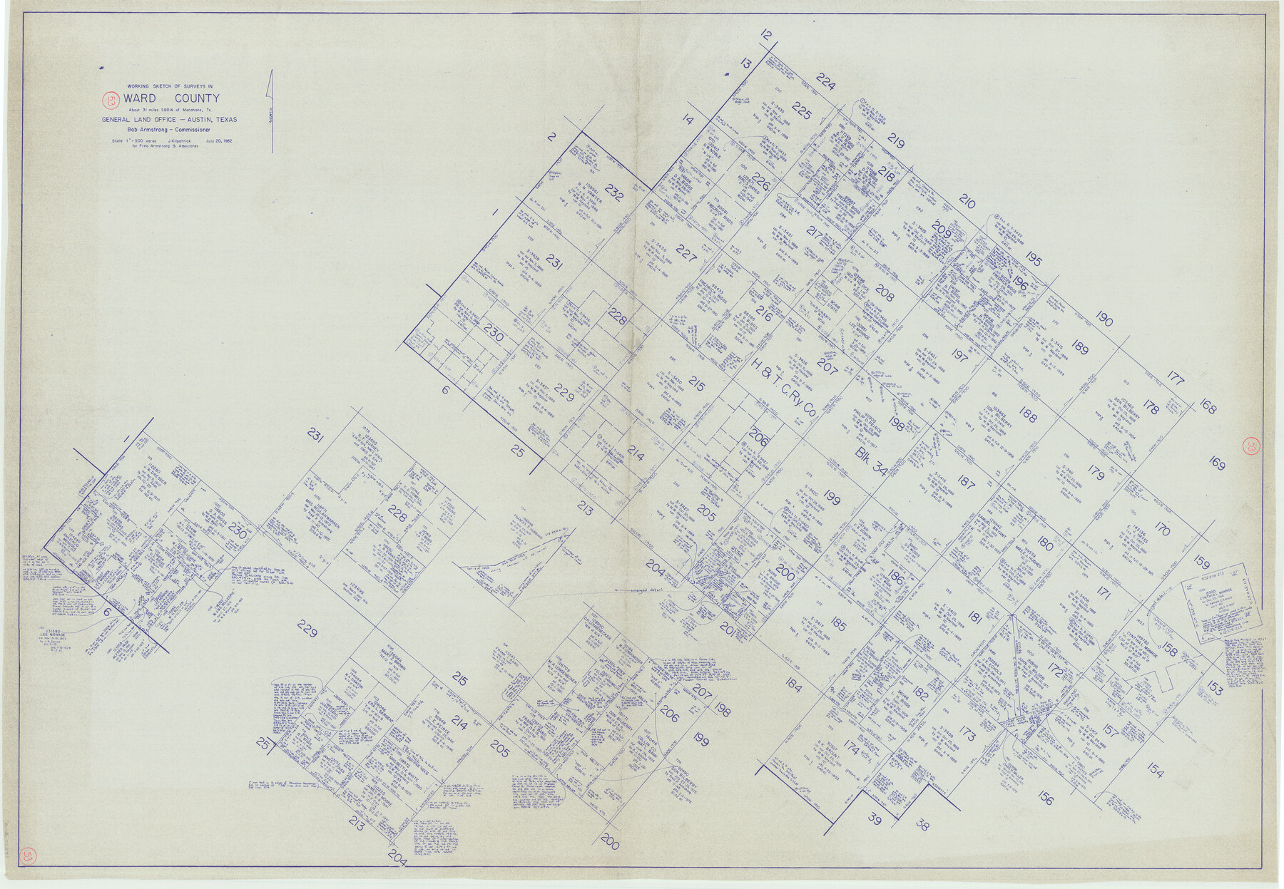
Ward County Working Sketch 53
-
Map/Doc
72359
-
Collection
General Map Collection
-
Counties
Ward
-
Subjects
Cadastral Surveying Working Sketch
-
Height x Width
37.0 x 53.4 inches
94.0 x 135.6 cm
Part of: General Map Collection
El Paso County Rolled Sketch 50
![8876, El Paso County Rolled Sketch 50, General Map Collection](https://historictexasmaps.com/wmedia_w700/maps/8876-1.tif.jpg)
Print $40.00
- Digital $50.00
El Paso County Rolled Sketch 50
1956
Size 20.7 x 80.1 inches
Map/Doc 8876
Rusk County Rolled Sketch 13
![7548, Rusk County Rolled Sketch 13, General Map Collection](https://historictexasmaps.com/wmedia_w700/maps/7548.tif.jpg)
Print $20.00
- Digital $50.00
Rusk County Rolled Sketch 13
Size 30.1 x 26.4 inches
Map/Doc 7548
[Surveys along the Leon River and Plum Creek]
![255, [Surveys along the Leon River and Plum Creek], General Map Collection](https://historictexasmaps.com/wmedia_w700/maps/255.tif.jpg)
Print $2.00
- Digital $50.00
[Surveys along the Leon River and Plum Creek]
1846
Size 11.7 x 7.6 inches
Map/Doc 255
Van Zandt County Sketch File 46
![39503, Van Zandt County Sketch File 46, General Map Collection](https://historictexasmaps.com/wmedia_w700/pdf_converted_jpg/qi_pdf_thumbnail_14876.jpg)
Print $2.00
- Digital $50.00
Van Zandt County Sketch File 46
Size 8.0 x 12.7 inches
Map/Doc 39503
[Beaumont, Sour Lake and Western Ry. Right of Way and Alignment - Frisco]
![64115, [Beaumont, Sour Lake and Western Ry. Right of Way and Alignment - Frisco], General Map Collection](https://historictexasmaps.com/wmedia_w700/maps/64115.tif.jpg)
Print $20.00
- Digital $50.00
[Beaumont, Sour Lake and Western Ry. Right of Way and Alignment - Frisco]
1910
Size 20.1 x 45.9 inches
Map/Doc 64115
Flight Mission No. CUG-3P, Frame 89, Kleberg County
![86259, Flight Mission No. CUG-3P, Frame 89, Kleberg County, General Map Collection](https://historictexasmaps.com/wmedia_w700/pdf_converted_jpg/qi_pdf_thumbnail_33403.jpg)
Print $20.00
- Digital $50.00
Flight Mission No. CUG-3P, Frame 89, Kleberg County
1956
Size 18.4 x 22.1 inches
Map/Doc 86259
Gillespie County Working Sketch 9
![63172, Gillespie County Working Sketch 9, General Map Collection](https://historictexasmaps.com/wmedia_w700/maps/63172.tif.jpg)
Print $20.00
- Digital $50.00
Gillespie County Working Sketch 9
Size 27.7 x 32.3 inches
Map/Doc 63172
[Sketch for Mineral Application 24072, San Jacinto River]
![65593, [Sketch for Mineral Application 24072, San Jacinto River], General Map Collection](https://historictexasmaps.com/wmedia_w700/maps/65593.tif.jpg)
Print $20.00
- Digital $50.00
[Sketch for Mineral Application 24072, San Jacinto River]
1929
Size 19.1 x 16.9 inches
Map/Doc 65593
Flight Mission No. BRE-1P, Frame 117, Nueces County
![86683, Flight Mission No. BRE-1P, Frame 117, Nueces County, General Map Collection](https://historictexasmaps.com/wmedia_w700/pdf_converted_jpg/qi_pdf_thumbnail_33822.jpg)
Print $20.00
- Digital $50.00
Flight Mission No. BRE-1P, Frame 117, Nueces County
1956
Size 18.4 x 22.3 inches
Map/Doc 86683
Bowie County Sketch File 6a
![14844, Bowie County Sketch File 6a, General Map Collection](https://historictexasmaps.com/wmedia_w700/pdf_converted_jpg/qi_pdf_thumbnail_9513.jpg)
Print $8.00
- Digital $50.00
Bowie County Sketch File 6a
1927
Size 10.6 x 8.6 inches
Map/Doc 14844
Jasper County Sketch File 36
![27872, Jasper County Sketch File 36, General Map Collection](https://historictexasmaps.com/wmedia_w700/pdf_converted_jpg/qi_pdf_thumbnail_12238.jpg)
Print $32.00
- Digital $50.00
Jasper County Sketch File 36
1987
Size 11.2 x 8.6 inches
Map/Doc 27872
Concho County Working Sketch 10
![68192, Concho County Working Sketch 10, General Map Collection](https://historictexasmaps.com/wmedia_w700/maps/68192.tif.jpg)
Print $20.00
- Digital $50.00
Concho County Working Sketch 10
Size 21.2 x 15.6 inches
Map/Doc 68192
You may also like
Henderson County Working Sketch 10
![66143, Henderson County Working Sketch 10, General Map Collection](https://historictexasmaps.com/wmedia_w700/maps/66143.tif.jpg)
Print $20.00
- Digital $50.00
Henderson County Working Sketch 10
Size 29.7 x 18.8 inches
Map/Doc 66143
Liberty County Sketch File 26
![29943, Liberty County Sketch File 26, General Map Collection](https://historictexasmaps.com/wmedia_w700/pdf_converted_jpg/qi_pdf_thumbnail_12690.jpg)
Print $10.00
- Digital $50.00
Liberty County Sketch File 26
1859
Size 8.3 x 9.2 inches
Map/Doc 29943
Harris County Historic Topographic 20
![65831, Harris County Historic Topographic 20, General Map Collection](https://historictexasmaps.com/wmedia_w700/maps/65831.tif.jpg)
Print $20.00
- Digital $50.00
Harris County Historic Topographic 20
1915
Size 29.3 x 22.6 inches
Map/Doc 65831
Presidio County Working Sketch 61
![71738, Presidio County Working Sketch 61, General Map Collection](https://historictexasmaps.com/wmedia_w700/maps/71738.tif.jpg)
Print $20.00
- Digital $50.00
Presidio County Working Sketch 61
Size 40.0 x 35.0 inches
Map/Doc 71738
Mitchell County Boundary File 3
![57369, Mitchell County Boundary File 3, General Map Collection](https://historictexasmaps.com/wmedia_w700/pdf_converted_jpg/qi_pdf_thumbnail_16585.jpg)
Print $6.00
- Digital $50.00
Mitchell County Boundary File 3
Size 11.2 x 8.6 inches
Map/Doc 57369
Sketch of the route from the camp on the Concho River to Phantom Hill, Texas
![2005, Sketch of the route from the camp on the Concho River to Phantom Hill, Texas, General Map Collection](https://historictexasmaps.com/wmedia_w700/maps/2005.tif.jpg)
Print $20.00
- Digital $50.00
Sketch of the route from the camp on the Concho River to Phantom Hill, Texas
1852
Size 30.0 x 11.9 inches
Map/Doc 2005
Bexar County Working Sketch 20
![67336, Bexar County Working Sketch 20, General Map Collection](https://historictexasmaps.com/wmedia_w700/maps/67336.tif.jpg)
Print $20.00
- Digital $50.00
Bexar County Working Sketch 20
1982
Size 42.4 x 43.6 inches
Map/Doc 67336
Township 11 North Range 15 West, Western District, Louisiana
![65870, Township 11 North Range 15 West, Western District, Louisiana, General Map Collection](https://historictexasmaps.com/wmedia_w700/maps/65870.tif.jpg)
Print $20.00
- Digital $50.00
Township 11 North Range 15 West, Western District, Louisiana
1834
Size 19.7 x 24.6 inches
Map/Doc 65870
Flight Mission No. DQO-2K, Frame 143, Galveston County
![85040, Flight Mission No. DQO-2K, Frame 143, Galveston County, General Map Collection](https://historictexasmaps.com/wmedia_w700/pdf_converted_jpg/qi_pdf_thumbnail_32252.jpg)
Print $20.00
- Digital $50.00
Flight Mission No. DQO-2K, Frame 143, Galveston County
1952
Size 18.8 x 22.5 inches
Map/Doc 85040
Right of Way and Track Map, St. Louis, Brownsville & Mexico Railway operated by St. Louis Brownsville & Mexico Ry. Co., Jefferson Lake Oil Company
![64612, Right of Way and Track Map, St. Louis, Brownsville & Mexico Railway operated by St. Louis Brownsville & Mexico Ry. Co., Jefferson Lake Oil Company, General Map Collection](https://historictexasmaps.com/wmedia_w700/maps/64612.tif.jpg)
Print $40.00
- Digital $50.00
Right of Way and Track Map, St. Louis, Brownsville & Mexico Railway operated by St. Louis Brownsville & Mexico Ry. Co., Jefferson Lake Oil Company
1937
Size 25.3 x 57.1 inches
Map/Doc 64612
Montague County Working Sketch 5
![71071, Montague County Working Sketch 5, General Map Collection](https://historictexasmaps.com/wmedia_w700/maps/71071.tif.jpg)
Print $20.00
- Digital $50.00
Montague County Working Sketch 5
Size 24.9 x 20.9 inches
Map/Doc 71071
Dimmit County Working Sketch 41
![68702, Dimmit County Working Sketch 41, General Map Collection](https://historictexasmaps.com/wmedia_w700/maps/68702.tif.jpg)
Print $4.00
- Digital $50.00
Dimmit County Working Sketch 41
Size 26.1 x 27.0 inches
Map/Doc 68702