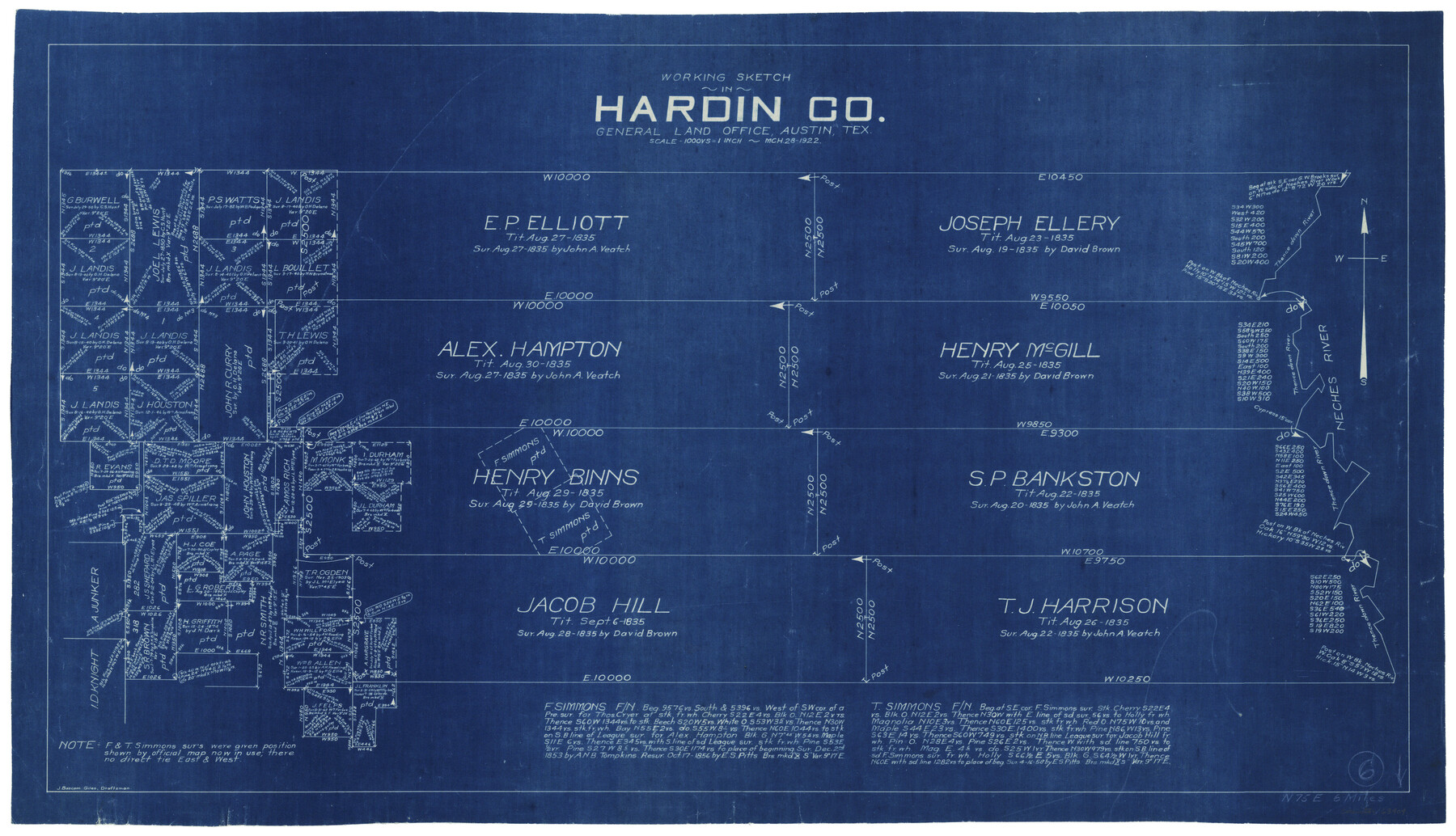
Hardin County Working Sketch 6
-
Map/Doc
63404
-
Collection
General Map Collection
-
Object Dates
3/28/1922 (Creation Date)
-
People and Organizations
J. Bascom Giles (Draftsman)
-
Counties
Hardin
-
Subjects
Surveying Working Sketch
-
Height x Width
16.2 x 28.4 inches
41.2 x 72.1 cm
-
Scale
1" = 1000 varas
Part of: General Map Collection
Stonewall County Rolled Sketch 28

Print $20.00
- Digital $50.00
Stonewall County Rolled Sketch 28
Size 42.8 x 46.5 inches
Map/Doc 9967
Illinois, Missouri, Iowa, Wisconsin and Minnesota

Print $20.00
- Digital $50.00
Illinois, Missouri, Iowa, Wisconsin and Minnesota
1885
Size 12.2 x 9.0 inches
Map/Doc 93521
Revised Map of the State of Texas

Print $20.00
- Digital $50.00
Revised Map of the State of Texas
1876
Size 20.6 x 20.6 inches
Map/Doc 96795
Liberty County Sketch File 49

Print $2.00
- Digital $50.00
Liberty County Sketch File 49
1857
Size 11.8 x 8.3 inches
Map/Doc 30013
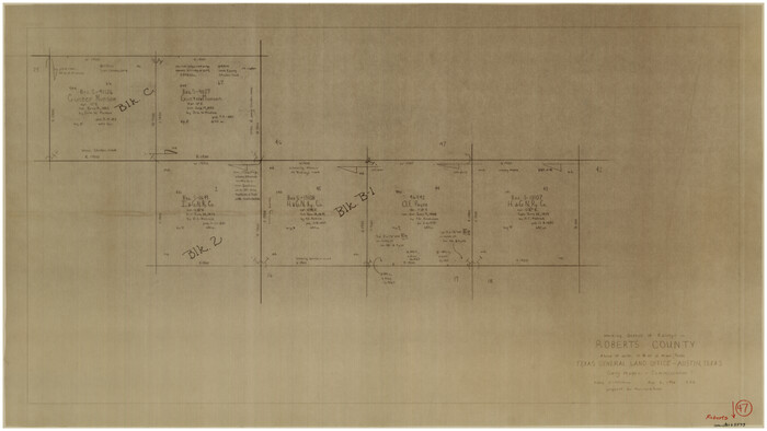
Roberts County Working Sketch 47
Print $20.00
- Digital $50.00
Roberts County Working Sketch 47
1996
Size 19.6 x 34.7 inches
Map/Doc 63573
Val Verde County Working Sketch 117

Print $20.00
- Digital $50.00
Val Verde County Working Sketch 117
1993
Size 34.8 x 37.0 inches
Map/Doc 82843
Willacy County Aerial Photograph Index Sheet 4

Print $20.00
- Digital $50.00
Willacy County Aerial Photograph Index Sheet 4
1955
Size 24.3 x 19.8 inches
Map/Doc 83759
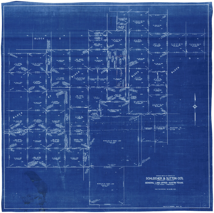
Schleicher County Working Sketch 24
Print $20.00
- Digital $50.00
Schleicher County Working Sketch 24
1955
Size 42.6 x 43.3 inches
Map/Doc 63826
Freestone County Sketch File 26

Print $22.00
- Digital $50.00
Freestone County Sketch File 26
1880
Size 8.2 x 13.2 inches
Map/Doc 23096
McMullen County Working Sketch 13

Print $20.00
- Digital $50.00
McMullen County Working Sketch 13
1938
Size 27.2 x 21.6 inches
Map/Doc 70714
Presidio de San Antonio de Bejar y Villa de San Fernando

Print $20.00
- Digital $50.00
Presidio de San Antonio de Bejar y Villa de San Fernando
1986
Size 21.8 x 26.0 inches
Map/Doc 87386
Hunt County Boundary File 7

Print $14.00
- Digital $50.00
Hunt County Boundary File 7
Size 14.1 x 8.7 inches
Map/Doc 55228
You may also like
General Highway Map, Willacy County, Texas

Print $20.00
General Highway Map, Willacy County, Texas
1961
Size 18.2 x 24.7 inches
Map/Doc 79711
Jeff Davis County Rolled Sketch 19A

Print $20.00
- Digital $50.00
Jeff Davis County Rolled Sketch 19A
Size 33.3 x 39.0 inches
Map/Doc 9266
Rusk County Sketch File Y

Print $6.00
Rusk County Sketch File Y
1845
Size 16.7 x 11.0 inches
Map/Doc 35537

Rockwall County Working Sketch 3

Print $20.00
- Digital $50.00
Rockwall County Working Sketch 3
1923
Size 22.6 x 18.7 inches
Map/Doc 63595
Flight Mission No. DCL-5C, Frame 47, Kenedy County

Print $20.00
- Digital $50.00
Flight Mission No. DCL-5C, Frame 47, Kenedy County
1943
Size 18.6 x 22.3 inches
Map/Doc 85843
Property Line Map, Housing Authority of the City of Lubbock, Texas

Print $20.00
- Digital $50.00
Property Line Map, Housing Authority of the City of Lubbock, Texas
1946
Size 19.4 x 25.4 inches
Map/Doc 92777
In the Supreme Court of the United States The State of Oklahoma, Complainant vs. The State of Texas, Defendant, The United States of America, Intervener - 1920

Print $20.00
- Digital $50.00
In the Supreme Court of the United States The State of Oklahoma, Complainant vs. The State of Texas, Defendant, The United States of America, Intervener - 1920
1920
Size 31.6 x 37.2 inches
Map/Doc 75115
Dr. S. C. Arnett Farm Part Section 22, Block JS

Print $20.00
- Digital $50.00
Dr. S. C. Arnett Farm Part Section 22, Block JS
Size 16.0 x 18.7 inches
Map/Doc 92306
Maverick County Sketch File 22

Print $32.00
- Digital $50.00
Maverick County Sketch File 22
1892
Size 5.5 x 6.3 inches
Map/Doc 31136
Cottle County, Texas

Print $20.00
- Digital $50.00
Cottle County, Texas
1891
Size 23.1 x 17.0 inches
Map/Doc 619
Brewster County Rolled Sketch 101

Print $40.00
- Digital $50.00
Brewster County Rolled Sketch 101
1927
Size 74.7 x 50.4 inches
Map/Doc 10649