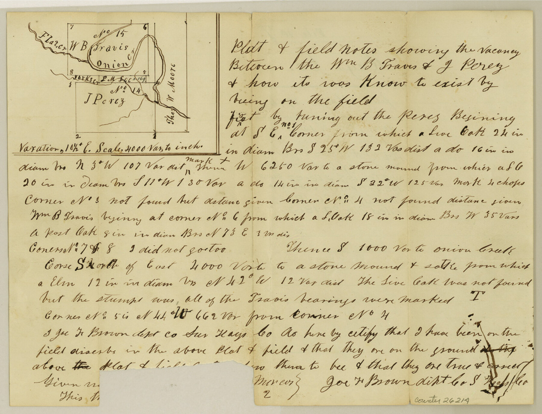
Hays County Sketch File 10
[Plat and field notes of surveys showing vacancy between the W. B. Travis and J. Perez surveys]
-
Map/Doc
26214
-
Collection
General Map Collection
-
Object Dates
1862/3/29 (Creation Date)
-
People and Organizations
Joe F. Brown (Surveyor/Engineer)
-
Counties
Hays
-
Subjects
Surveying Sketch File
-
Height x Width
8.2 x 10.7 inches
20.8 x 27.2 cm
-
Medium
paper, manuscript
-
Scale
1:4000
-
Features
Onion Creek
Flat Creek
Part of: General Map Collection
Childress Co.

Print $20.00
- Digital $50.00
Childress Co.
1978
Size 44.6 x 33.7 inches
Map/Doc 77237
[Sketch for Mineral Application 13271- Trinity River]
![65627, [Sketch for Mineral Application 13271- Trinity River], General Map Collection](https://historictexasmaps.com/wmedia_w700/maps/65627.tif.jpg)
Print $40.00
- Digital $50.00
[Sketch for Mineral Application 13271- Trinity River]
1925
Size 63.4 x 25.0 inches
Map/Doc 65627
Hutchinson County Rolled Sketch 21

Print $20.00
- Digital $50.00
Hutchinson County Rolled Sketch 21
Size 28.4 x 36.1 inches
Map/Doc 6286
Falls County Sketch File 11

Print $13.00
- Digital $50.00
Falls County Sketch File 11
1859
Size 12.6 x 9.8 inches
Map/Doc 22352
Zavala County Sketch File B

Print $34.00
- Digital $50.00
Zavala County Sketch File B
1908
Size 13.5 x 8.9 inches
Map/Doc 41364
Hale County Boundary File 10

Print $62.00
- Digital $50.00
Hale County Boundary File 10
Size 37.9 x 9.4 inches
Map/Doc 54145
Bexar County Rolled Sketch 3

Print $20.00
- Digital $50.00
Bexar County Rolled Sketch 3
1873
Size 25.5 x 18.0 inches
Map/Doc 5136
[San Antonio & Aransas Pass]
![64208, [San Antonio & Aransas Pass], General Map Collection](https://historictexasmaps.com/wmedia_w700/maps/64208.tif.jpg)
Print $40.00
- Digital $50.00
[San Antonio & Aransas Pass]
Size 17.0 x 50.7 inches
Map/Doc 64208
Duval County Sketch File 77

Print $20.00
- Digital $50.00
Duval County Sketch File 77
1967
Size 20.4 x 15.5 inches
Map/Doc 11411
Eastland County Working Sketch 31

Print $20.00
- Digital $50.00
Eastland County Working Sketch 31
1955
Size 33.9 x 33.9 inches
Map/Doc 68812
Right of Way & Track Map, St. Louis, Brownsville & Mexico Ry. operated by St. Louis, Brownsville & Mexico Ry. Co.

Print $40.00
- Digital $50.00
Right of Way & Track Map, St. Louis, Brownsville & Mexico Ry. operated by St. Louis, Brownsville & Mexico Ry. Co.
1919
Size 25.5 x 57.1 inches
Map/Doc 64624
Cherokee County Sketch File 16

Print $44.00
- Digital $50.00
Cherokee County Sketch File 16
1862
Size 10.0 x 8.0 inches
Map/Doc 18152
You may also like
Map of T.C. Spearman's Lands in Gaines, Terry & Yoakum Counties, Texas

Print $20.00
- Digital $50.00
Map of T.C. Spearman's Lands in Gaines, Terry & Yoakum Counties, Texas
1917
Size 44.9 x 37.0 inches
Map/Doc 89779

Brooks County Rolled Sketch 24

Print $20.00
- Digital $50.00
Brooks County Rolled Sketch 24
1945
Size 42.8 x 23.7 inches
Map/Doc 5344
English Field Notes of the Spanish Archives - Books JMH, MCMCHB, TGI

English Field Notes of the Spanish Archives - Books JMH, MCMCHB, TGI
1835
Map/Doc 96547
Andrews County Block A-46

Print $20.00
- Digital $50.00
Andrews County Block A-46
Size 23.4 x 15.3 inches
Map/Doc 92638
Duval County Rolled Sketch HD

Print $20.00
- Digital $50.00
Duval County Rolled Sketch HD
1939
Size 22.8 x 32.8 inches
Map/Doc 5767
Duval County Working Sketch 40

Print $20.00
- Digital $50.00
Duval County Working Sketch 40
1960
Size 19.5 x 16.6 inches
Map/Doc 68764
Map of Wood County Showing Location of the Texas and Pacific Railway

Print $20.00
- Digital $50.00
Map of Wood County Showing Location of the Texas and Pacific Railway
1872
Size 19.1 x 23.8 inches
Map/Doc 64135
McLennan County School Land Leagues 3 & 4

Print $20.00
- Digital $50.00
McLennan County School Land Leagues 3 & 4
Size 11.0 x 18.4 inches
Map/Doc 90828
Lampasas County Working Sketch 1

Print $20.00
- Digital $50.00
Lampasas County Working Sketch 1
Size 16.2 x 20.3 inches
Map/Doc 70278

Flight Mission No. BRE-2P, Frame 136, Nueces County

Print $20.00
- Digital $50.00
Flight Mission No. BRE-2P, Frame 136, Nueces County
1956
Size 18.5 x 22.6 inches
Map/Doc 86809