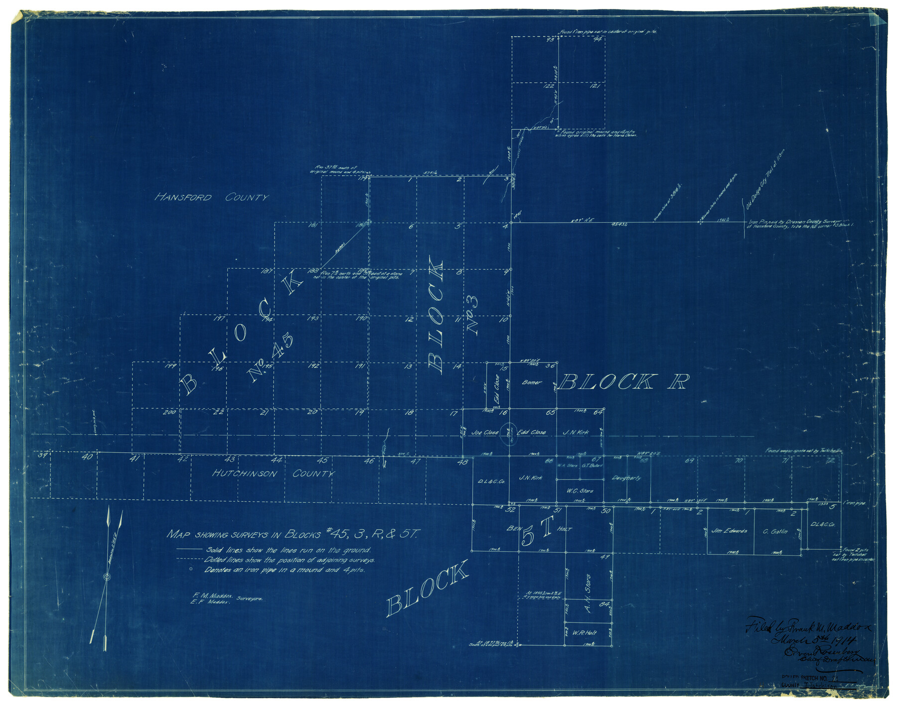
Hutchinson County Rolled Sketch 21
Map showing surveys in Blocks # 45, 3, R, & 5T
-
Map/Doc
6286
-
Collection
General Map Collection
-
Object Dates
3/5/1914 (File Date)
-
People and Organizations
F.M. Maddox (Surveyor/Engineer)
E.F. Maddox (Surveyor/Engineer)
-
Counties
Hutchinson Hansford
-
Subjects
Surveying Rolled Sketch
-
Height x Width
28.4 x 36.1 inches
72.1 x 91.7 cm
-
Medium
blueprint/diazo
Part of: General Map Collection
Upshur County Sketch File 6

Print $4.00
- Digital $50.00
Upshur County Sketch File 6
1855
Size 8.7 x 13.0 inches
Map/Doc 38742
Montgomery County Working Sketch 66

Print $20.00
- Digital $50.00
Montgomery County Working Sketch 66
1967
Size 24.7 x 29.0 inches
Map/Doc 71173
Hale County Sketch File 23

Print $4.00
- Digital $50.00
Hale County Sketch File 23
1903
Size 11.2 x 8.5 inches
Map/Doc 24759
Chicago, Rock Island, Texas & Mexico

Print $40.00
- Digital $50.00
Chicago, Rock Island, Texas & Mexico
1920
Size 25.9 x 120.3 inches
Map/Doc 64422
Zapata County Sketch File 13a

Print $20.00
- Digital $50.00
Zapata County Sketch File 13a
1935
Size 21.4 x 16.0 inches
Map/Doc 12722
Reagan County

Print $40.00
- Digital $50.00
Reagan County
1940
Size 48.4 x 37.5 inches
Map/Doc 73270
Texas Railroad Map

Print $20.00
- Digital $50.00
Texas Railroad Map
1981
Size 34.8 x 35.6 inches
Map/Doc 2101
Val Verde County Working Sketch 65

Print $20.00
- Digital $50.00
Val Verde County Working Sketch 65
1960
Size 30.9 x 31.8 inches
Map/Doc 72200
Right of Way and Track Map of The Missouri, Kansas & Texas Railway of Texas

Print $40.00
- Digital $50.00
Right of Way and Track Map of The Missouri, Kansas & Texas Railway of Texas
1918
Size 25.2 x 106.9 inches
Map/Doc 64531
Panola County Working Sketch 41

Print $20.00
- Digital $50.00
Panola County Working Sketch 41
1995
Map/Doc 71450
Flight Mission No. BRE-2P, Frame 52, Nueces County

Print $20.00
- Digital $50.00
Flight Mission No. BRE-2P, Frame 52, Nueces County
1956
Size 18.5 x 22.4 inches
Map/Doc 86754
Val Verde County Working Sketch 106

Print $20.00
- Digital $50.00
Val Verde County Working Sketch 106
1984
Size 30.4 x 40.8 inches
Map/Doc 72241
You may also like
Jefferson County Working Sketch 42

Print $20.00
- Digital $50.00
Jefferson County Working Sketch 42
1996
Size 31.7 x 47.2 inches
Map/Doc 66586
[Sketch showing H. & G. N. Blk. 1]
![89634, [Sketch showing H. & G. N. Blk. 1], Twichell Survey Records](https://historictexasmaps.com/wmedia_w700/maps/89634-1.tif.jpg)
Print $40.00
- Digital $50.00
[Sketch showing H. & G. N. Blk. 1]
Size 27.1 x 60.6 inches
Map/Doc 89634
Record of Translations of Titles - DeWitt's Colony, Vol. 4

Record of Translations of Titles - DeWitt's Colony, Vol. 4
1872
Map/Doc 94549
[Map showing T&P Lands in El Paso County]
![88932, [Map showing T&P Lands in El Paso County], Library of Congress](https://historictexasmaps.com/wmedia_w700/maps/88932.tif.jpg)
Print $20.00
[Map showing T&P Lands in El Paso County]
Size 22.2 x 17.1 inches
Map/Doc 88932
Ward County Working Sketch 12

Print $20.00
- Digital $50.00
Ward County Working Sketch 12
1947
Size 23.4 x 22.7 inches
Map/Doc 72318
Sutton County Sketch File 59

Print $20.00
- Digital $50.00
Sutton County Sketch File 59
Size 24.6 x 16.5 inches
Map/Doc 12394
Leon County Sketch File 2

Print $4.00
- Digital $50.00
Leon County Sketch File 2
1852
Size 8.1 x 5.1 inches
Map/Doc 29711
Blanco County Sketch File 37

Print $4.00
- Digital $50.00
Blanco County Sketch File 37
Size 8.7 x 14.1 inches
Map/Doc 14646


Haskell County Sketch File 10

Print $8.00
- Digital $50.00
Haskell County Sketch File 10
Size 13.0 x 8.2 inches
Map/Doc 26136
Erath County Working Sketch 12

Print $20.00
- Digital $50.00
Erath County Working Sketch 12
1964
Size 22.3 x 23.1 inches
Map/Doc 69093