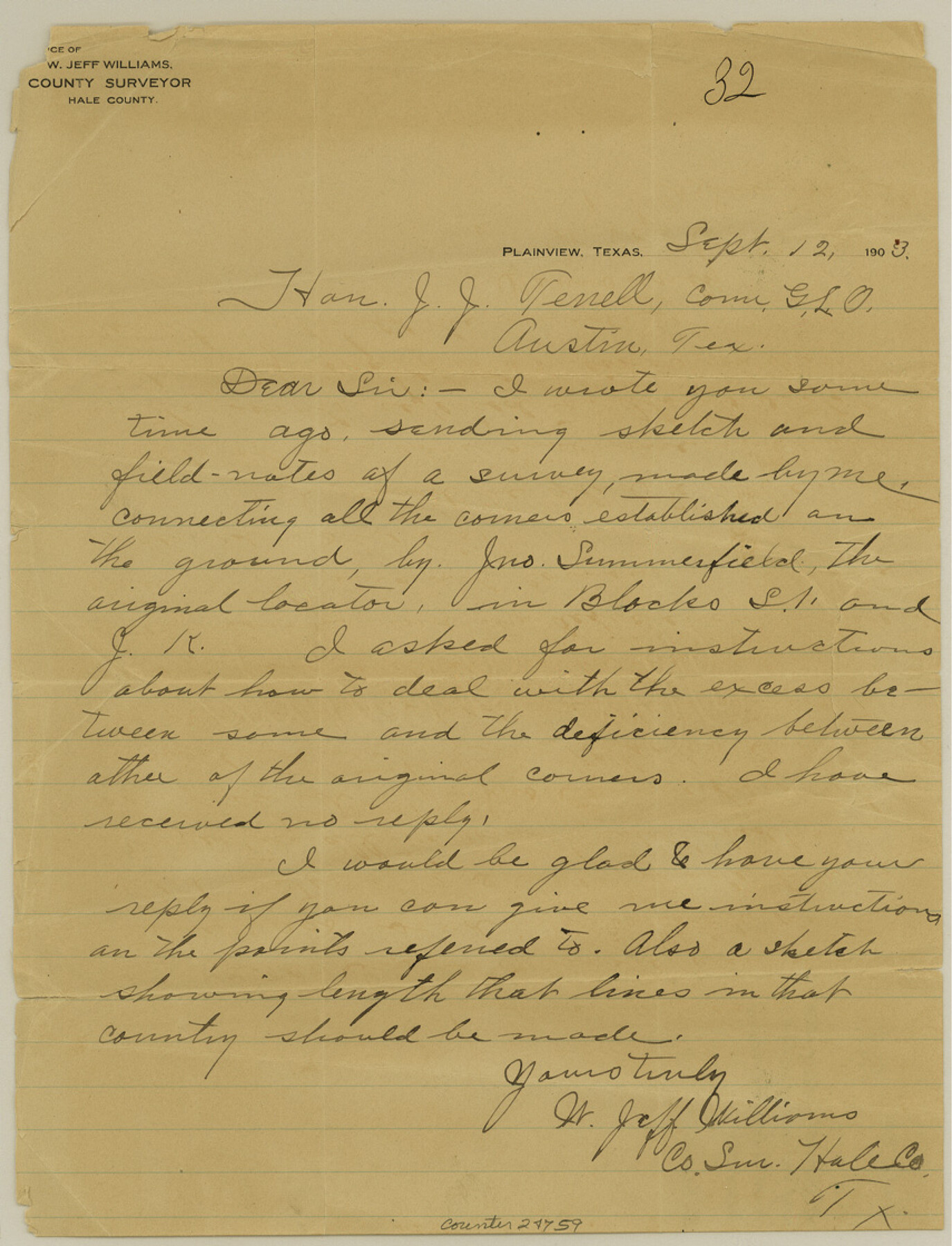
Hale County Sketch File 23
[Letter from Hale County Surveyor asking for instructions as to how to make certain surveys]
-
Map/Doc
24759
-
Collection
General Map Collection
-
Object Dates
1903/9/12 (Creation Date)
1903/8/1 (Creation Date)
-
People and Organizations
W. Jeff Williams (Surveyor/Engineer)
Jonathan Summerfield (Surveyor/Engineer)
-
Counties
Hale
-
Subjects
Surveying Sketch File
-
Height x Width
11.2 x 8.5 inches
28.4 x 21.6 cm
-
Medium
multi-page, multi-format
-
Features
White River
Brazos River
Plainview
Part of: General Map Collection
Eastland County Boundary File 26a

Print $32.00
- Digital $50.00
Eastland County Boundary File 26a
Size 12.7 x 8.1 inches
Map/Doc 52813
Crockett County Sketch File 39

Print $20.00
- Digital $50.00
Crockett County Sketch File 39
1889
Size 19.7 x 32.6 inches
Map/Doc 11221
Jasper County Sketch File 28

Print $10.00
- Digital $50.00
Jasper County Sketch File 28
1947
Size 11.4 x 8.8 inches
Map/Doc 27853
McMullen County Sketch File 29

Print $20.00
- Digital $50.00
McMullen County Sketch File 29
1883
Size 35.8 x 15.4 inches
Map/Doc 12062

Knox County Sketch File 25

Print $10.00
- Digital $50.00
Knox County Sketch File 25
1872
Size 12.8 x 8.2 inches
Map/Doc 29257
Cottle County Sketch File 7

Print $20.00
- Digital $50.00
Cottle County Sketch File 7
1893
Size 22.1 x 20.7 inches
Map/Doc 11191
Permanent Lakes and Marshes for Mineral Development

Print $20.00
- Digital $50.00
Permanent Lakes and Marshes for Mineral Development
Size 30.6 x 35.2 inches
Map/Doc 73593
Chambers County NRC Article 33.136 Sketch 15

Print $62.00
Chambers County NRC Article 33.136 Sketch 15
2025
Map/Doc 97510
Irion County Working Sketch Graphic Index

Print $20.00
- Digital $50.00
Irion County Working Sketch Graphic Index
1944
Size 44.0 x 40.9 inches
Map/Doc 76588
Milam County Working Sketch 8

Print $20.00
- Digital $50.00
Milam County Working Sketch 8
1970
Size 27.1 x 30.7 inches
Map/Doc 71023
Presidio County Working Sketch 65

Print $20.00
- Digital $50.00
Presidio County Working Sketch 65
1958
Size 31.1 x 26.3 inches
Map/Doc 71742
You may also like
Flight Mission No. DAG-28K, Frame 28, Matagorda County

Print $20.00
- Digital $50.00
Flight Mission No. DAG-28K, Frame 28, Matagorda County
1953
Size 18.5 x 22.5 inches
Map/Doc 86596
[Sketch for Mineral Application 16700 - Pecos River Bed]
![2806, [Sketch for Mineral Application 16700 - Pecos River Bed], General Map Collection](https://historictexasmaps.com/wmedia_w700/maps/2806.tif.jpg)
Print $20.00
- Digital $50.00
[Sketch for Mineral Application 16700 - Pecos River Bed]
1927
Size 20.3 x 29.1 inches
Map/Doc 2806
Flight Mission No. CRC-2R, Frame 183, Chambers County

Print $20.00
- Digital $50.00
Flight Mission No. CRC-2R, Frame 183, Chambers County
1956
Size 18.7 x 22.3 inches
Map/Doc 84761
Southern Part of Laguna Madre

Print $20.00
- Digital $50.00
Southern Part of Laguna Madre
1985
Size 45.3 x 36.6 inches
Map/Doc 73547
Right of Way and Track Map, Texas & New Orleans R.R. operated by the T. & N. O. R.R. Co., Rusk Branch

Print $40.00
- Digital $50.00
Right of Way and Track Map, Texas & New Orleans R.R. operated by the T. & N. O. R.R. Co., Rusk Branch
1918
Size 24.7 x 56.2 inches
Map/Doc 64243
Hale County Sketch File 27

Print $20.00
- Digital $50.00
Hale County Sketch File 27
Size 12.1 x 28.5 inches
Map/Doc 11598
Flight Mission No. DQN-2K, Frame 191, Calhoun County

Print $20.00
- Digital $50.00
Flight Mission No. DQN-2K, Frame 191, Calhoun County
1953
Size 18.8 x 22.4 inches
Map/Doc 84332
Limestone County Sketch File 24

Print $8.00
- Digital $50.00
Limestone County Sketch File 24
1942
Size 11.2 x 8.8 inches
Map/Doc 30206
Edwards County Sketch File 2 and 3

Print $8.00
- Digital $50.00
Edwards County Sketch File 2 and 3
1874
Size 9.3 x 4.1 inches
Map/Doc 21676
Bastrop County Working Sketch 6

Print $20.00
- Digital $50.00
Bastrop County Working Sketch 6
1923
Size 37.5 x 31.2 inches
Map/Doc 67306

Stephens County Sketch File 1

Print $20.00
- Digital $50.00
Stephens County Sketch File 1
1857
Size 19.2 x 16.1 inches
Map/Doc 12347