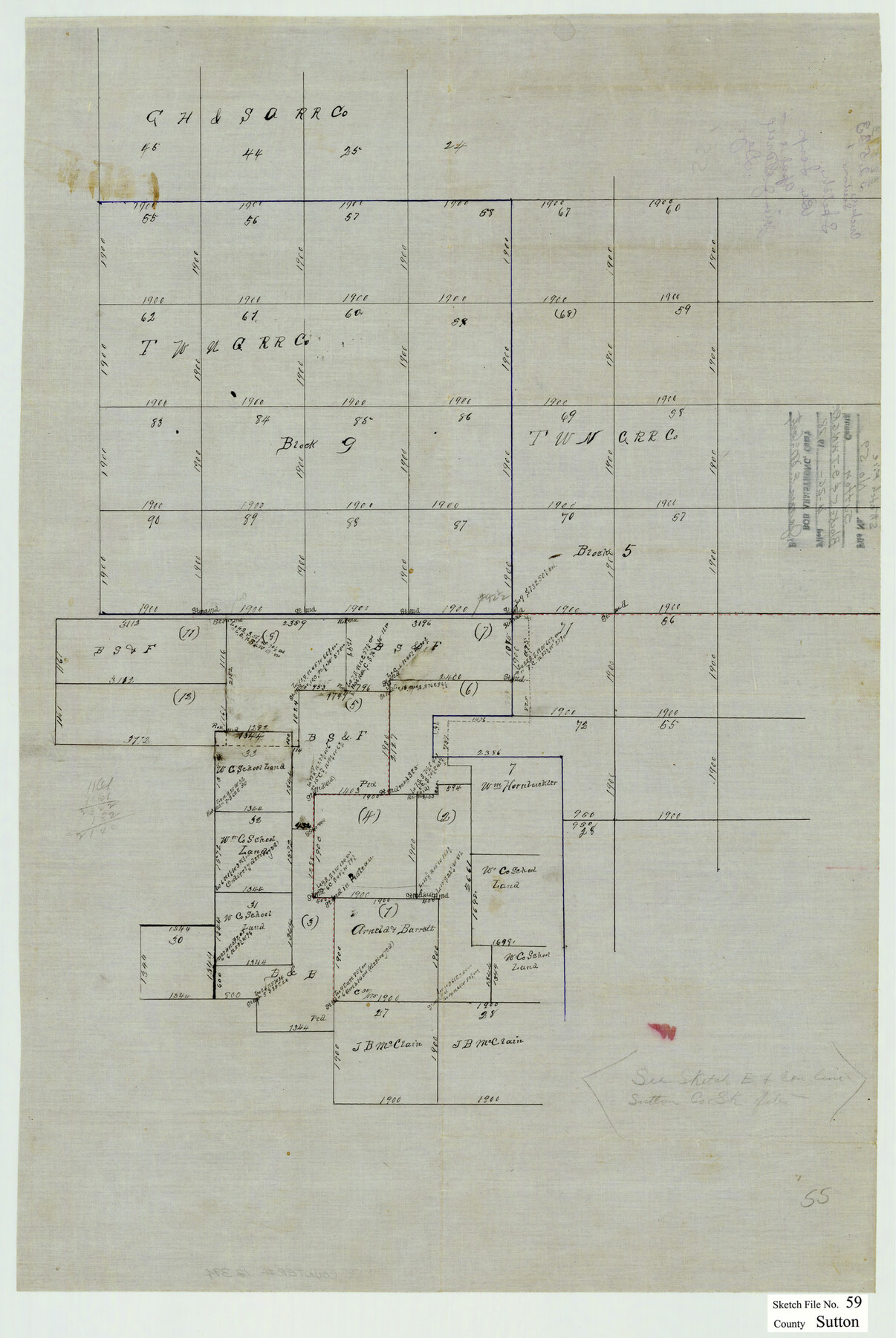
Sutton County Sketch File 59
Blocks 5 & 9, TWNGRRCo., Sutton County, Texas
-
Map/Doc
12394
-
Collection
General Map Collection
-
Object Dates
4/26/1978 (File Date)
-
People and Organizations
General Land Office (Surveyor/Engineer)
-
Counties
Sutton
-
Subjects
Surveying Sketch File
-
Height x Width
24.6 x 16.5 inches
62.5 x 41.9 cm
-
Medium
paper, manuscript
Part of: General Map Collection
Culberson County Working Sketch 4

Print $20.00
- Digital $50.00
Culberson County Working Sketch 4
Size 37.7 x 32.2 inches
Map/Doc 68456
Nueces County Rolled Sketch 55

Print $20.00
- Digital $50.00
Nueces County Rolled Sketch 55
1978
Size 25.7 x 37.5 inches
Map/Doc 6892
Culberson County Working Sketch 62

Print $20.00
- Digital $50.00
Culberson County Working Sketch 62
1975
Size 32.2 x 24.6 inches
Map/Doc 68516
Flight Mission No. DCL-7C, Frame 14, Kenedy County

Print $20.00
- Digital $50.00
Flight Mission No. DCL-7C, Frame 14, Kenedy County
1943
Size 15.3 x 15.2 inches
Map/Doc 86006
Nueces County Aerial Photograph Index Sheet 21

Print $20.00
- Digital $50.00
Nueces County Aerial Photograph Index Sheet 21
1938
Size 24.3 x 20.2 inches
Map/Doc 86842
Lampasas County Sketch File 6

Print $4.00
- Digital $50.00
Lampasas County Sketch File 6
1871
Size 8.0 x 6.8 inches
Map/Doc 29400
Newton County Rolled Sketch 5

Print $20.00
- Digital $50.00
Newton County Rolled Sketch 5
Size 20.5 x 42.5 inches
Map/Doc 6841
Galveston Entrance

Print $20.00
- Digital $50.00
Galveston Entrance
1925
Size 18.5 x 24.1 inches
Map/Doc 69859
Trinity County Working Sketch 23

Print $20.00
- Digital $50.00
Trinity County Working Sketch 23
2010
Size 23.4 x 33.6 inches
Map/Doc 89259
Travis County Working Sketch 48

Print $40.00
- Digital $50.00
Travis County Working Sketch 48
1981
Size 53.7 x 40.3 inches
Map/Doc 69432
Hemphill County Sketch File 1

Print $40.00
- Digital $50.00
Hemphill County Sketch File 1
Size 17.1 x 13.9 inches
Map/Doc 26279
Grimes County Working Sketch 2

Print $20.00
- Digital $50.00
Grimes County Working Sketch 2
1941
Size 13.2 x 20.9 inches
Map/Doc 63293
You may also like
Map of the United States Engraved to Illustrate Mitchell's School and Family Geography

Print $20.00
Map of the United States Engraved to Illustrate Mitchell's School and Family Geography
1839
Size 11.6 x 17.4 inches
Map/Doc 79734
Flight Mission No. CRC-2R, Frame 120, Chambers County

Print $20.00
- Digital $50.00
Flight Mission No. CRC-2R, Frame 120, Chambers County
1956
Size 18.5 x 22.3 inches
Map/Doc 84744
Newton County Sketch File O

Print $4.00
- Digital $50.00
Newton County Sketch File O
Size 6.8 x 8.3 inches
Map/Doc 32413
Erath County Rolled Sketch 4

Print $20.00
- Digital $50.00
Erath County Rolled Sketch 4
Size 29.1 x 40.9 inches
Map/Doc 5866
Texas-New Mexico Boundary Along Rio Grande (plats)

Print $390.00
Texas-New Mexico Boundary Along Rio Grande (plats)
1933
Map/Doc 81691
Reeves County Boundary File 1

Print $12.00
- Digital $50.00
Reeves County Boundary File 1
Size 14.1 x 8.5 inches
Map/Doc 58195
Intracoastal Waterway - Galveston Bay to West Bay including Galveston Bay Entrance

Print $20.00
- Digital $50.00
Intracoastal Waterway - Galveston Bay to West Bay including Galveston Bay Entrance
1962
Size 26.8 x 38.4 inches
Map/Doc 69937
Maps of Gulf Intracoastal Waterway, Texas - Sabine River to the Rio Grande and connecting waterways including ship channels

Print $20.00
- Digital $50.00
Maps of Gulf Intracoastal Waterway, Texas - Sabine River to the Rio Grande and connecting waterways including ship channels
1966
Size 14.5 x 22.2 inches
Map/Doc 61932
Garza County Sketch File D

Print $20.00
- Digital $50.00
Garza County Sketch File D
1901
Size 18.4 x 12.2 inches
Map/Doc 11550
Montgomery County Sketch File 34

Print $8.00
- Digital $50.00
Montgomery County Sketch File 34
1949
Size 14.4 x 8.7 inches
Map/Doc 31904
San Jacinto County Working Sketch 5

Print $20.00
- Digital $50.00
San Jacinto County Working Sketch 5
1934
Size 16.5 x 21.2 inches
Map/Doc 63718
[Southeast Yoakum County, Southwest Terry County and North Gaines County]
![91876, [Southeast Yoakum County, Southwest Terry County and North Gaines County], Twichell Survey Records](https://historictexasmaps.com/wmedia_w700/maps/91876-1.tif.jpg)
Print $20.00
- Digital $50.00
[Southeast Yoakum County, Southwest Terry County and North Gaines County]
Size 20.7 x 16.6 inches
Map/Doc 91876