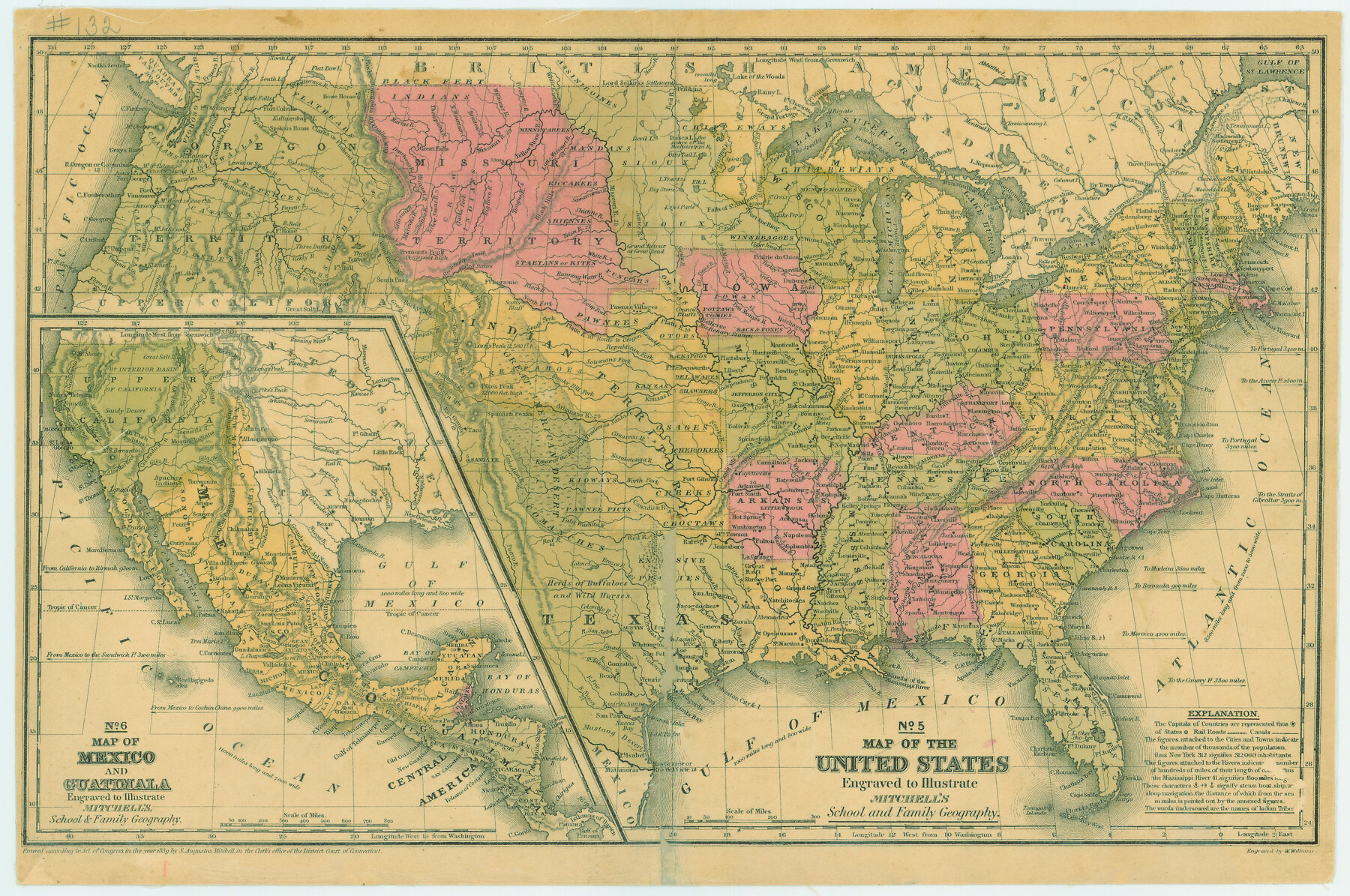
Map of the United States Engraved to Illustrate Mitchell's School and Family Geography
[Inset: Map of Mexico and Guatimala (sic) Engraved to Illustrate Mitchell's School and Family Geography]
-
Map/Doc
79734
-
Collection
Texas State Library and Archives
-
Object Dates
1839 (Creation Date)
-
People and Organizations
S. Augustus Mitchell (Publisher)
W. Williams (Printer)
-
Subjects
Atlas Republic of Texas United States
-
Height x Width
11.6 x 17.4 inches
29.5 x 44.2 cm
-
Comments
Prints available courtesy of the Texas State Library and Archives.
More info can be found here: TSLAC Map 00132
Part of: Texas State Library and Archives
General Highway Map, Gillespie County, Texas

Print $20.00
General Highway Map, Gillespie County, Texas
1961
Size 18.1 x 24.5 inches
Map/Doc 79479
General Highway Map, Bexar County, Texas

Print $20.00
General Highway Map, Bexar County, Texas
1961
Size 18.4 x 25.0 inches
Map/Doc 79370
General Highway Map, Stephens County, Texas

Print $20.00
General Highway Map, Stephens County, Texas
1961
Size 25.0 x 18.2 inches
Map/Doc 79660
General Highway Map, Jefferson County, Texas

Print $20.00
General Highway Map, Jefferson County, Texas
1940
Size 24.8 x 18.6 inches
Map/Doc 79144
General Highway Map, Smith County, Texas

Print $20.00
General Highway Map, Smith County, Texas
1961
Size 25.1 x 18.3 inches
Map/Doc 79654
Principal Watersheds of Texas

Print $20.00
Principal Watersheds of Texas
1935
Size 34.8 x 45.1 inches
Map/Doc 76306
General Highway Map. Detail of Cities and Towns in Lubbock County, Texas [Lubbock and vicinity]
![79181, General Highway Map. Detail of Cities and Towns in Lubbock County, Texas [Lubbock and vicinity], Texas State Library and Archives](https://historictexasmaps.com/wmedia_w700/maps/79181.tif.jpg)
Print $20.00
General Highway Map. Detail of Cities and Towns in Lubbock County, Texas [Lubbock and vicinity]
1940
Size 18.3 x 24.8 inches
Map/Doc 79181
Official Highway Map of Texas

Print $20.00
Official Highway Map of Texas
1926
Size 25.0 x 24.9 inches
Map/Doc 79744
Map of Texas with Parts of the Adjoining States

Print $20.00
Map of Texas with Parts of the Adjoining States
1833
Size 29.3 x 23.3 inches
Map/Doc 79740
General Highway Map, Medina County, Texas

Print $20.00
General Highway Map, Medina County, Texas
1940
Size 18.3 x 24.6 inches
Map/Doc 79195
General Highway Map, Lampasas County, Texas

Print $20.00
General Highway Map, Lampasas County, Texas
1961
Size 18.2 x 24.7 inches
Map/Doc 79563
Mapa de la Sierra Gorda y costa del Seno Mexicano desde la ciudad de Querétaro hasta la Bahía del Espíritu Santo, sus rios, ensenadas y provincias pacificadas por Don José de Escandón

Print $20.00
Mapa de la Sierra Gorda y costa del Seno Mexicano desde la ciudad de Querétaro hasta la Bahía del Espíritu Santo, sus rios, ensenadas y provincias pacificadas por Don José de Escandón
1792
Size 21.4 x 16.8 inches
Map/Doc 89047
You may also like
Flight Mission No. DAH-9M, Frame 163, Orange County

Print $20.00
- Digital $50.00
Flight Mission No. DAH-9M, Frame 163, Orange County
1953
Size 18.4 x 22.4 inches
Map/Doc 86862
Jeff Davis County Sketch File 30

Print $26.00
- Digital $50.00
Jeff Davis County Sketch File 30
1922
Size 14.1 x 8.5 inches
Map/Doc 28014
Stonewall County Rolled Sketch 26

Print $40.00
- Digital $50.00
Stonewall County Rolled Sketch 26
1954
Size 49.4 x 32.8 inches
Map/Doc 9965
Maverick County Rolled Sketch 23

Print $91.00
- Digital $50.00
Maverick County Rolled Sketch 23
1965
Size 9.5 x 14.8 inches
Map/Doc 46786
[Maps of surveys in Reeves & Culberson Cos]
![61140, [Maps of surveys in Reeves & Culberson Cos], General Map Collection](https://historictexasmaps.com/wmedia_w700/maps/61140.tif.jpg)
Print $20.00
- Digital $50.00
[Maps of surveys in Reeves & Culberson Cos]
1937
Size 30.6 x 24.9 inches
Map/Doc 61140
Tierra Blanca Water Conservation Project Dam

Print $20.00
- Digital $50.00
Tierra Blanca Water Conservation Project Dam
1937
Size 37.7 x 25.1 inches
Map/Doc 92157
Andrews County Working Sketch 27

Print $20.00
- Digital $50.00
Andrews County Working Sketch 27
1984
Size 19.1 x 16.2 inches
Map/Doc 67073
[Lynn County School Land Leagues 292, 293, PSL Block C-30, and D. W. RR. Co. Block H]
![90797, [Lynn County School Land Leagues 292, 293, PSL Block C-30, and D. W. RR. Co. Block H], Twichell Survey Records](https://historictexasmaps.com/wmedia_w700/maps/90797-1.tif.jpg)
Print $20.00
- Digital $50.00
[Lynn County School Land Leagues 292, 293, PSL Block C-30, and D. W. RR. Co. Block H]
Size 21.3 x 20.6 inches
Map/Doc 90797
Upton County Rolled Sketch 54

Print $20.00
- Digital $50.00
Upton County Rolled Sketch 54
Size 23.5 x 35.6 inches
Map/Doc 8089
Medina County Rolled Sketch 14

Print $20.00
- Digital $50.00
Medina County Rolled Sketch 14
1980
Size 29.2 x 32.0 inches
Map/Doc 6748
[Worksheets related to the Wilson Strickland survey and vicinity]
![91269, [Worksheets related to the Wilson Strickland survey and vicinity], Twichell Survey Records](https://historictexasmaps.com/wmedia_w700/maps/91269.tif.jpg)
Print $20.00
- Digital $50.00
[Worksheets related to the Wilson Strickland survey and vicinity]
Size 25.7 x 21.7 inches
Map/Doc 91269
Dickens County Working Sketch 11

Print $40.00
- Digital $50.00
Dickens County Working Sketch 11
1969
Size 52.6 x 37.8 inches
Map/Doc 68659