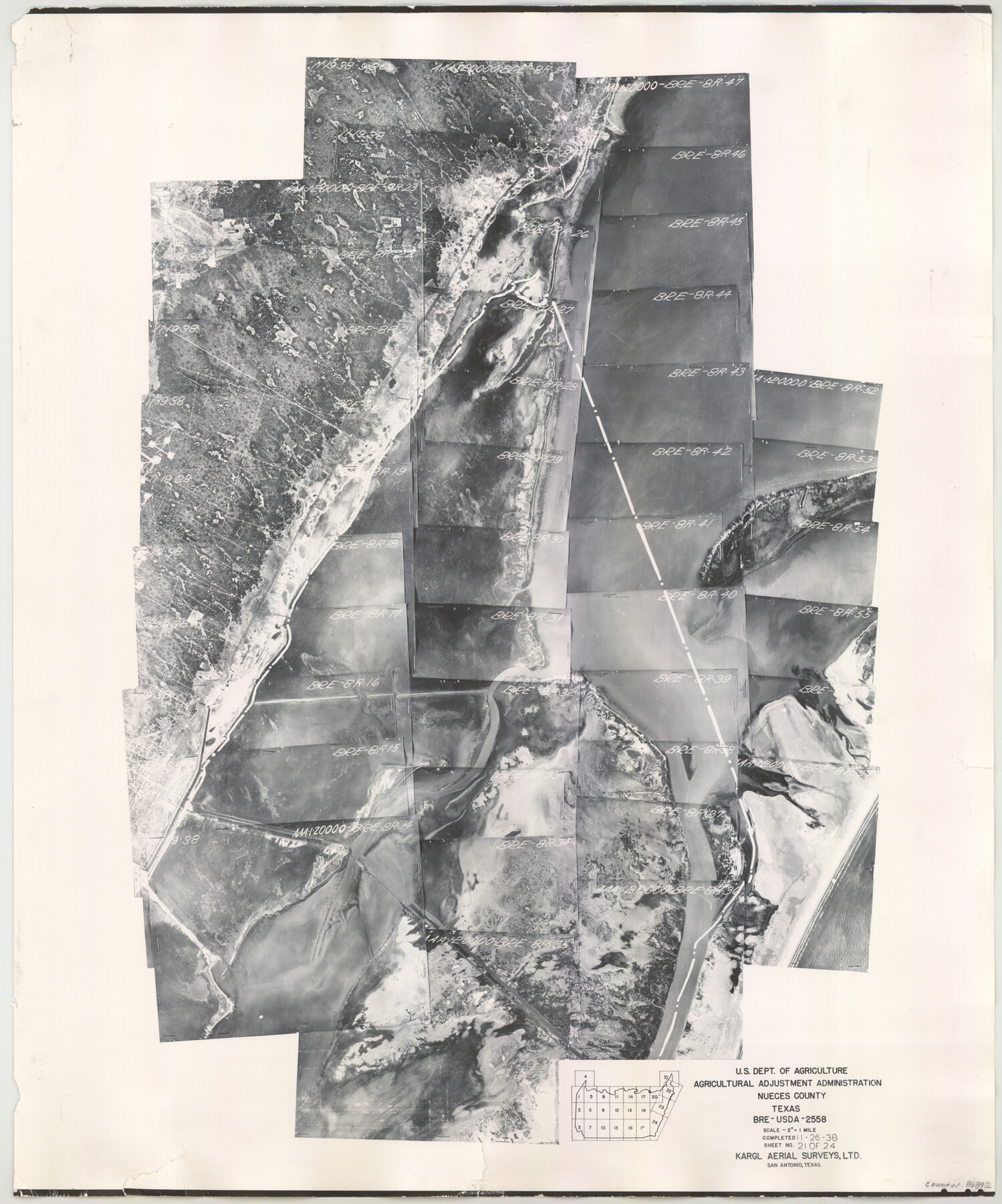
Nueces County Aerial Photograph Index Sheet 21
Index Map of Aerial Photograph Flight Mission No. BRE
-
Map/Doc
86842
-
Collection
General Map Collection
-
Object Dates
1938/11/26 (Creation Date)
-
People and Organizations
U. S. Department of Agriculture (Publisher)
-
Counties
Nueces
-
Subjects
Aerial Photograph
-
Height x Width
24.3 x 20.2 inches
61.7 x 51.3 cm
-
Medium
photograph
-
Scale
2640 feet
-
Comments
Flying completed November 26, 1938 by Kargl Aerial Surveys, LTD. of San Antonio, Texas. Received in office May 7, 1962.
Part of: General Map Collection
Young County Rolled Sketch 9

Print $20.00
- Digital $50.00
Young County Rolled Sketch 9
1921
Size 24.0 x 22.6 inches
Map/Doc 8297
Culberson County Working Sketch 39

Print $40.00
- Digital $50.00
Culberson County Working Sketch 39
1966
Size 37.9 x 82.7 inches
Map/Doc 68492
El Paso County Sketch File 22a

Print $52.00
- Digital $50.00
El Paso County Sketch File 22a
1888
Size 14.2 x 8.7 inches
Map/Doc 22042
Controlled Mosaic by Jack Amman Photogrammetric Engineers, Inc - Sheet 51

Print $20.00
- Digital $50.00
Controlled Mosaic by Jack Amman Photogrammetric Engineers, Inc - Sheet 51
1954
Size 20.0 x 24.0 inches
Map/Doc 83510
Mills County Working Sketch 6

Print $3.00
- Digital $50.00
Mills County Working Sketch 6
Size 12.1 x 10.9 inches
Map/Doc 71036
Dimmit County Rolled Sketch 5

Print $20.00
- Digital $50.00
Dimmit County Rolled Sketch 5
1904
Size 42.7 x 18.2 inches
Map/Doc 5715
Pecos County Working Sketch 12
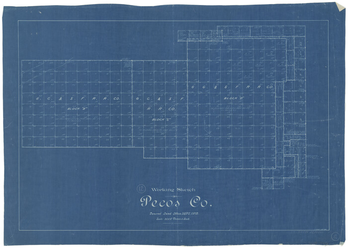
Print $20.00
- Digital $50.00
Pecos County Working Sketch 12
1912
Size 21.3 x 30.0 inches
Map/Doc 71482
Nolan County Rolled Sketch 2A

Print $20.00
- Digital $50.00
Nolan County Rolled Sketch 2A
Size 26.9 x 34.8 inches
Map/Doc 6861
[Surveys in McMullen and McGloin's Colony along the San Antonio River]
![30, [Surveys in McMullen and McGloin's Colony along the San Antonio River], General Map Collection](https://historictexasmaps.com/wmedia_w700/maps/30-1.tif.jpg)
Print $20.00
- Digital $50.00
[Surveys in McMullen and McGloin's Colony along the San Antonio River]
1828
Size 19.3 x 24.5 inches
Map/Doc 30
Flight Mission No. DIX-3P, Frame 165, Aransas County

Print $20.00
- Digital $50.00
Flight Mission No. DIX-3P, Frame 165, Aransas County
1956
Size 17.8 x 18.4 inches
Map/Doc 83771
Map of Newton Co.

Print $20.00
- Digital $50.00
Map of Newton Co.
1905
Size 47.5 x 38.9 inches
Map/Doc 5020
Liberty County Sketch File 21

Print $5.00
- Digital $50.00
Liberty County Sketch File 21
1858
Size 7.9 x 13.0 inches
Map/Doc 29928
You may also like
Dickens County Sketch File F1

Print $28.00
- Digital $50.00
Dickens County Sketch File F1
Size 11.4 x 8.7 inches
Map/Doc 20849
Map showing location of Texas Prison Farms surveyed for the Texas Prison System

Print $20.00
- Digital $50.00
Map showing location of Texas Prison Farms surveyed for the Texas Prison System
1934
Size 15.6 x 12.3 inches
Map/Doc 94277
Brazos River, Ball Hill Sheet/Big Creek

Print $6.00
- Digital $50.00
Brazos River, Ball Hill Sheet/Big Creek
1926
Size 34.3 x 30.0 inches
Map/Doc 65281
Coryell County Sketch File 13

Print $4.00
- Digital $50.00
Coryell County Sketch File 13
1872
Size 5.0 x 8.5 inches
Map/Doc 19366
Gray County Sketch File 10

Print $14.00
- Digital $50.00
Gray County Sketch File 10
Size 9.7 x 6.3 inches
Map/Doc 24445
Waller County Working Sketch 3

Print $20.00
- Digital $50.00
Waller County Working Sketch 3
1959
Size 35.4 x 28.8 inches
Map/Doc 72302
Kimble County Sketch File 10

Print $23.00
- Digital $50.00
Kimble County Sketch File 10
Size 18.5 x 15.6 inches
Map/Doc 28931
Hardin County Sketch File 56a

Print $40.00
- Digital $50.00
Hardin County Sketch File 56a
Size 12.7 x 15.9 inches
Map/Doc 25226
Orange County Sketch File 34

Print $20.00
- Digital $50.00
Orange County Sketch File 34
1929
Size 23.5 x 27.7 inches
Map/Doc 12126
C No. 2 - Preliminary Sketch of Chincoteague Inlet and Shoals in the Vicinity - Sea Coast of Virginia

Print $20.00
- Digital $50.00
C No. 2 - Preliminary Sketch of Chincoteague Inlet and Shoals in the Vicinity - Sea Coast of Virginia
1852
Size 16.5 x 19.4 inches
Map/Doc 97206
Reagan County Working Sketch 42

Print $20.00
- Digital $50.00
Reagan County Working Sketch 42
1973
Size 19.9 x 37.0 inches
Map/Doc 71884
El Paso County Rolled Sketch 52

Print $20.00
- Digital $50.00
El Paso County Rolled Sketch 52
1960
Size 18.4 x 24.4 inches
Map/Doc 5841