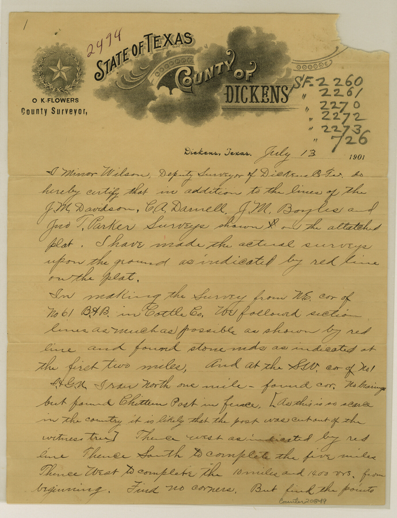
Dickens County Sketch File F1
[Explanation from Deputy Surveyor of Dickens County]
-
Map/Doc
20849
-
Collection
General Map Collection
-
Object Dates
1901/7/18 (File Date)
-
People and Organizations
Minor Wilson (Surveyor/Engineer)
J.H. Gibson (Surveyor/Engineer)
-
Counties
Dickens Cottle Motley King
-
Subjects
Surveying Sketch File
-
Height x Width
11.4 x 8.7 inches
29.0 x 22.1 cm
-
Medium
paper, manuscript
-
Features
Buford's Creek
Part of: General Map Collection

South Sulphur River, Bonner Point Sheet

Print $20.00
- Digital $50.00
South Sulphur River, Bonner Point Sheet
1922
Size 32.9 x 35.7 inches
Map/Doc 65164
Williamson County Rolled Sketch 9

Print $20.00
- Digital $50.00
Williamson County Rolled Sketch 9
Size 25.3 x 32.8 inches
Map/Doc 8266
Flight Mission No. BRE-1P, Frame 11, Nueces County

Print $20.00
- Digital $50.00
Flight Mission No. BRE-1P, Frame 11, Nueces County
1956
Size 18.6 x 22.6 inches
Map/Doc 86619
Jeff Davis County Sketch File 43

Print $10.00
- Digital $50.00
Jeff Davis County Sketch File 43
1970
Size 14.2 x 8.6 inches
Map/Doc 28066
[Sketch for Mineral Application 1112 - Colorado River, H. E. Chambers]
![65642, [Sketch for Mineral Application 1112 - Colorado River, H. E. Chambers], General Map Collection](https://historictexasmaps.com/wmedia_w700/maps/65642.tif.jpg)
Print $20.00
- Digital $50.00
[Sketch for Mineral Application 1112 - Colorado River, H. E. Chambers]
1918
Size 17.1 x 28.4 inches
Map/Doc 65642
Nolan County Sketch File 2

Print $40.00
- Digital $50.00
Nolan County Sketch File 2
Size 49.5 x 41.6 inches
Map/Doc 10556
Howard County Rolled Sketch 6

Print $20.00
- Digital $50.00
Howard County Rolled Sketch 6
Size 17.3 x 18.1 inches
Map/Doc 6235
Pecos County Rolled Sketch 102

Print $20.00
- Digital $50.00
Pecos County Rolled Sketch 102
Size 28.9 x 26.4 inches
Map/Doc 7250
Working Sketch No. IV in Pecos County

Print $20.00
- Digital $50.00
Working Sketch No. IV in Pecos County
1886
Size 36.7 x 23.6 inches
Map/Doc 3954
Runnels County Rolled Sketch 35

Print $20.00
- Digital $50.00
Runnels County Rolled Sketch 35
1950
Size 34.1 x 44.6 inches
Map/Doc 7523
Kleberg County Rolled Sketch 10-40

Print $20.00
- Digital $50.00
Kleberg County Rolled Sketch 10-40
1952
Size 38.1 x 34.0 inches
Map/Doc 9392
You may also like
Medina County Working Sketch 5

Print $20.00
- Digital $50.00
Medina County Working Sketch 5
1949
Size 38.5 x 37.3 inches
Map/Doc 70920
Sabine County Working Sketch 1

Print $20.00
- Digital $50.00
Sabine County Working Sketch 1
1922
Size 17.7 x 17.7 inches
Map/Doc 63672
Bosque County Working Sketch 13

Print $20.00
- Digital $50.00
Bosque County Working Sketch 13
1957
Size 17.2 x 14.5 inches
Map/Doc 67446
Hockley County Sketch File 16

Print $20.00
- Digital $50.00
Hockley County Sketch File 16
Size 23.6 x 30.9 inches
Map/Doc 11774
Kinney County Working Sketch 24

Print $20.00
- Digital $50.00
Kinney County Working Sketch 24
1950
Size 41.7 x 35.9 inches
Map/Doc 70206
[Blocks M17, M18, M23, H, I, Z, and XO2]
![91245, [Blocks M17, M18, M23, H, I, Z, and XO2], Twichell Survey Records](https://historictexasmaps.com/wmedia_w700/maps/91245-1.tif.jpg)
Print $20.00
- Digital $50.00
[Blocks M17, M18, M23, H, I, Z, and XO2]
Size 34.5 x 27.2 inches
Map/Doc 91245
Newton County Rolled Sketch 16

Print $20.00
- Digital $50.00
Newton County Rolled Sketch 16
Size 30.5 x 21.9 inches
Map/Doc 6846
Culberson County Working Sketch 30

Print $20.00
- Digital $50.00
Culberson County Working Sketch 30
1958
Size 29.3 x 30.2 inches
Map/Doc 68483
Travis County State Real Property Sketch 15

Print $20.00
- Digital $50.00
Travis County State Real Property Sketch 15
1995
Size 29.6 x 29.5 inches
Map/Doc 61674
Flight Mission No. DIX-8P, Frame 58, Aransas County

Print $20.00
- Digital $50.00
Flight Mission No. DIX-8P, Frame 58, Aransas County
1956
Size 18.6 x 22.5 inches
Map/Doc 83889
Nueces County Aerial Photograph Index Sheet 23

Print $20.00
- Digital $50.00
Nueces County Aerial Photograph Index Sheet 23
1938
Size 24.4 x 20.3 inches
Map/Doc 86844
