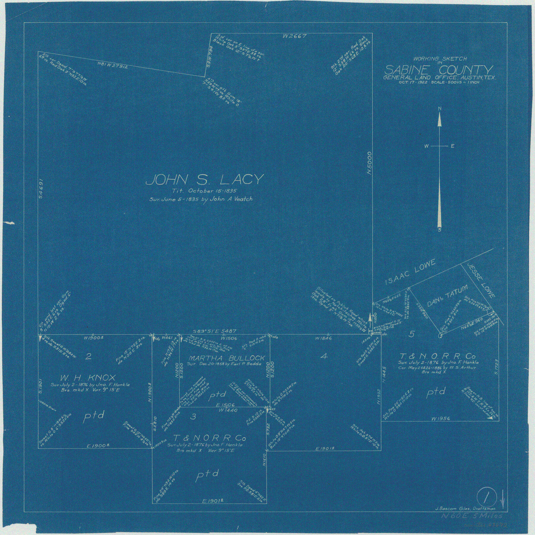
Sabine County Working Sketch 1
-
Map/Doc
63672
-
Collection
General Map Collection
-
Counties
Sabine
-
Subjects
Cadastral Surveying Working Sketch
-
Height x Width
17.7 x 17.7 inches
45.0 x 45.0 cm
Part of: General Map Collection
Jack County Working Sketch 2
![66428, Jack County Working Sketch 2, General Map Collection](https://historictexasmaps.com/wmedia_w700/maps/66428-1.tif.jpg)
Print $3.00
- Digital $50.00
Jack County Working Sketch 2
Size 10.9 x 17.7 inches
Map/Doc 66428
Wichita County Sketch File 2
![40030, Wichita County Sketch File 2, General Map Collection](https://historictexasmaps.com/wmedia_w700/pdf_converted_jpg/qi_pdf_thumbnail_15010.jpg)
Print $8.00
- Digital $50.00
Wichita County Sketch File 2
Size 9.0 x 10.8 inches
Map/Doc 40030
Matagorda County Rolled Sketch PHL
![9476, Matagorda County Rolled Sketch PHL, General Map Collection](https://historictexasmaps.com/wmedia_w700/maps/9476.tif.jpg)
Print $20.00
- Digital $50.00
Matagorda County Rolled Sketch PHL
1937
Size 37.3 x 40.0 inches
Map/Doc 9476
Colorado County Working Sketch 6
![68106, Colorado County Working Sketch 6, General Map Collection](https://historictexasmaps.com/wmedia_w700/maps/68106.tif.jpg)
Print $20.00
- Digital $50.00
Colorado County Working Sketch 6
Size 15.4 x 14.3 inches
Map/Doc 68106
Texas Gulf Coast, from the Sabine River to the Rio Grande as Subdivided for Mineral Development; Aransas, Nueces, Kleberg, Kenedy, Willacy, and Cameron Counties
![1940, Texas Gulf Coast, from the Sabine River to the Rio Grande as Subdivided for Mineral Development; Aransas, Nueces, Kleberg, Kenedy, Willacy, and Cameron Counties, General Map Collection](https://historictexasmaps.com/wmedia_w700/maps/1940.tif.jpg)
Print $40.00
- Digital $50.00
Texas Gulf Coast, from the Sabine River to the Rio Grande as Subdivided for Mineral Development; Aransas, Nueces, Kleberg, Kenedy, Willacy, and Cameron Counties
1976
Size 118.0 x 43.0 inches
Map/Doc 1940
Right of Way San Antonio and Aransas Pass Railway
![62561, Right of Way San Antonio and Aransas Pass Railway, General Map Collection](https://historictexasmaps.com/wmedia_w700/maps/62561.tif.jpg)
Print $4.00
- Digital $50.00
Right of Way San Antonio and Aransas Pass Railway
1919
Size 11.6 x 18.5 inches
Map/Doc 62561
Gaines County Sketch File 9
![11524, Gaines County Sketch File 9, General Map Collection](https://historictexasmaps.com/wmedia_w700/pdf_converted_jpg/qi_pdf_thumbnail_7966.jpg)
Print $20.00
- Digital $50.00
Gaines County Sketch File 9
Size 34.1 x 17.1 inches
Map/Doc 11524
Flight Mission No. CUG-3P, Frame 164, Kleberg County
![86284, Flight Mission No. CUG-3P, Frame 164, Kleberg County, General Map Collection](https://historictexasmaps.com/wmedia_w700/pdf_converted_jpg/qi_pdf_thumbnail_33428.jpg)
Print $20.00
- Digital $50.00
Flight Mission No. CUG-3P, Frame 164, Kleberg County
1956
Size 18.5 x 22.2 inches
Map/Doc 86284
Kleberg County Rolled Sketch 13
![6554, Kleberg County Rolled Sketch 13, General Map Collection](https://historictexasmaps.com/wmedia_w700/maps/6554.tif.jpg)
Print $20.00
- Digital $50.00
Kleberg County Rolled Sketch 13
1995
Size 39.3 x 33.8 inches
Map/Doc 6554
Reagan County Sketch File 27
![35021, Reagan County Sketch File 27, General Map Collection](https://historictexasmaps.com/wmedia_w700/pdf_converted_jpg/qi_pdf_thumbnail_13816.jpg)
Print $8.00
- Digital $50.00
Reagan County Sketch File 27
1949
Size 11.4 x 8.7 inches
Map/Doc 35021
Pecos County Working Sketch 114
![71587, Pecos County Working Sketch 114, General Map Collection](https://historictexasmaps.com/wmedia_w700/maps/71587.tif.jpg)
Print $40.00
- Digital $50.00
Pecos County Working Sketch 114
Size 75.7 x 38.0 inches
Map/Doc 71587
Stephens County
![4051, Stephens County, General Map Collection](https://historictexasmaps.com/wmedia_w700/maps/4051.tif.jpg)
Print $20.00
- Digital $50.00
Stephens County
1879
Size 27.8 x 19.6 inches
Map/Doc 4051
You may also like
Terrell County Sketch File 2-3
![](https://historictexasmaps.com/wmedia_w700/pdf_converted_jpg/qi_pdf_thumbnail_70612.jpg)
Print $38.00
- Digital $50.00
Terrell County Sketch File 2-3
1882
Size 9.1 x 7.7 inches
Map/Doc 37879
Hall County Working Sketch 6
![63334, Hall County Working Sketch 6, General Map Collection](https://historictexasmaps.com/wmedia_w700/maps/63334.tif.jpg)
Print $20.00
- Digital $50.00
Hall County Working Sketch 6
Size 21.8 x 21.6 inches
Map/Doc 63334
[San Antonio & Aransas Pass]
![64211, [San Antonio & Aransas Pass], General Map Collection](https://historictexasmaps.com/wmedia_w700/maps/64211.tif.jpg)
Print $2.00
- Digital $50.00
[San Antonio & Aransas Pass]
Size 11.6 x 8.2 inches
Map/Doc 64211
Kendall County Working Sketch 28a
![83097, Kendall County Working Sketch 28a, General Map Collection](https://historictexasmaps.com/wmedia_w700/maps/83097.tif.jpg)
Print $20.00
- Digital $50.00
Kendall County Working Sketch 28a
2006
Size 29.8 x 45.0 inches
Map/Doc 83097
Culberson County Working Sketch 63
![68517, Culberson County Working Sketch 63, General Map Collection](https://historictexasmaps.com/wmedia_w700/maps/68517.tif.jpg)
Print $20.00
- Digital $50.00
Culberson County Working Sketch 63
Size 34.1 x 24.9 inches
Map/Doc 68517
Map of the Lands Surveyed by the Memphis, El Paso & Pacific R.R. Company
![4844, Map of the Lands Surveyed by the Memphis, El Paso & Pacific R.R. Company, General Map Collection](https://historictexasmaps.com/wmedia_w700/maps/4844.tif.jpg)
Print $20.00
- Digital $50.00
Map of the Lands Surveyed by the Memphis, El Paso & Pacific R.R. Company
1859
Size 15.8 x 19.0 inches
Map/Doc 4844
General Highway Map. Detail of Cities and Towns in Dallas County, Texas [Dallas and vicinity]
![79068, General Highway Map. Detail of Cities and Towns in Dallas County, Texas [Dallas and vicinity], Texas State Library and Archives](https://historictexasmaps.com/wmedia_w700/maps/79068.tif.jpg)
Print $20.00
General Highway Map. Detail of Cities and Towns in Dallas County, Texas [Dallas and vicinity]
1936
Size 18.5 x 25.2 inches
Map/Doc 79068
General Highway Map, Wood County, Texas
![79718, General Highway Map, Wood County, Texas, Texas State Library and Archives](https://historictexasmaps.com/wmedia_w700/maps/79718.tif.jpg)
Print $20.00
General Highway Map, Wood County, Texas
1961
Size 18.1 x 24.8 inches
Map/Doc 79718
San Jacinto River and Tributaries, Texas - Survey of 1939
![60305, San Jacinto River and Tributaries, Texas - Survey of 1939, General Map Collection](https://historictexasmaps.com/wmedia_w700/maps/60305.tif.jpg)
Print $20.00
- Digital $50.00
San Jacinto River and Tributaries, Texas - Survey of 1939
1939
Size 28.0 x 40.3 inches
Map/Doc 60305
Van Zandt County Rolled Sketch 7
![8147, Van Zandt County Rolled Sketch 7, General Map Collection](https://historictexasmaps.com/wmedia_w700/maps/8147.tif.jpg)
Print $20.00
- Digital $50.00
Van Zandt County Rolled Sketch 7
1946
Size 27.0 x 20.4 inches
Map/Doc 8147
Flight Mission No. CUG-1P, Frame 50, Kleberg County
![86128, Flight Mission No. CUG-1P, Frame 50, Kleberg County, General Map Collection](https://historictexasmaps.com/wmedia_w700/pdf_converted_jpg/qi_pdf_thumbnail_33273.jpg)
Print $20.00
- Digital $50.00
Flight Mission No. CUG-1P, Frame 50, Kleberg County
1956
Size 18.6 x 22.3 inches
Map/Doc 86128
Sketch of the Northwest Portion of Hutchinson County
![91139, Sketch of the Northwest Portion of Hutchinson County, Twichell Survey Records](https://historictexasmaps.com/wmedia_w700/maps/91139-1.tif.jpg)
Print $20.00
- Digital $50.00
Sketch of the Northwest Portion of Hutchinson County
Size 19.8 x 13.6 inches
Map/Doc 91139