Pecos County Rolled Sketch 102
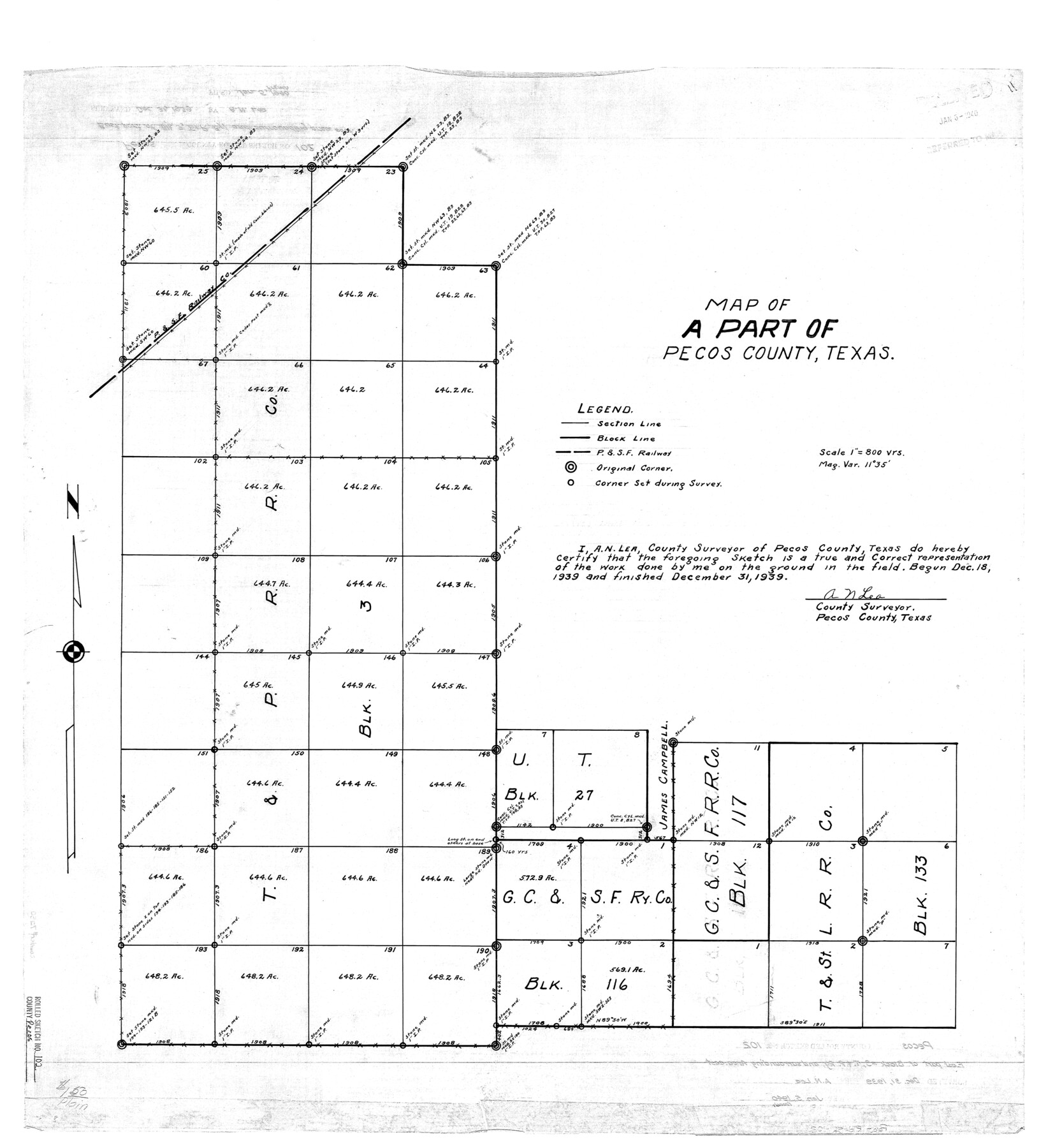
Map of a part of Pecos County, Texas
-
Map/Doc
7250
-
Collection
General Map Collection
-
Object Dates
1939/12/31 (Survey Date)
1940/1/31 (File Date)
-
People and Organizations
A.N. Lea (Surveyor/Engineer)
-
Counties
Pecos
-
Subjects
Surveying Rolled Sketch
-
Height x Width
28.9 x 26.4 inches
73.4 x 67.1 cm
-
Scale
1" = 800 varas
Part of: General Map Collection
Mason County Working Sketch 9

Print $20.00
- Digital $50.00
Mason County Working Sketch 9
1949
Size 34.4 x 29.4 inches
Map/Doc 70845
Coast Chart No. 210 Aransas Pass and Corpus Christi Bay with the coast to latitude 27° 12' Texas

Print $20.00
- Digital $50.00
Coast Chart No. 210 Aransas Pass and Corpus Christi Bay with the coast to latitude 27° 12' Texas
1887
Size 27.6 x 18.2 inches
Map/Doc 72789
Mills County Rolled Sketch 7

Print $20.00
- Digital $50.00
Mills County Rolled Sketch 7
2025
Size 23.7 x 29.8 inches
Map/Doc 97434
Hill County Sketch File 21a

Print $4.00
- Digital $50.00
Hill County Sketch File 21a
1887
Size 10.8 x 8.4 inches
Map/Doc 26503
Reconnaissance of Aransas Pass, Texas

Print $20.00
- Digital $50.00
Reconnaissance of Aransas Pass, Texas
1852
Size 14.4 x 13.6 inches
Map/Doc 76171
Kleberg County Rolled Sketch 10-8

Print $20.00
- Digital $50.00
Kleberg County Rolled Sketch 10-8
1951
Size 36.6 x 33.7 inches
Map/Doc 9370
Val Verde County Sketch File M

Print $18.00
- Digital $50.00
Val Verde County Sketch File M
1920
Size 14.5 x 9.1 inches
Map/Doc 39275
Potter County Sketch File 18

Print $20.00
- Digital $50.00
Potter County Sketch File 18
Size 34.3 x 43.4 inches
Map/Doc 10577
Presidio County Sketch File 116A

Print $63.00
- Digital $50.00
Presidio County Sketch File 116A
Size 17.0 x 11.0 inches
Map/Doc 34885
Cherokee County Working Sketch 25

Print $20.00
- Digital $50.00
Cherokee County Working Sketch 25
1972
Size 25.1 x 45.5 inches
Map/Doc 67980
Duval County Rolled Sketch 30A

Print $40.00
- Digital $50.00
Duval County Rolled Sketch 30A
1896
Size 59.7 x 40.8 inches
Map/Doc 76145
[Sketch for Mineral Application 16696-16697, Pecos River]
![65614, [Sketch for Mineral Application 16696-16697, Pecos River], General Map Collection](https://historictexasmaps.com/wmedia_w700/maps/65614.tif.jpg)
Print $40.00
- Digital $50.00
[Sketch for Mineral Application 16696-16697, Pecos River]
Size 42.6 x 69.4 inches
Map/Doc 65614
You may also like
Cass County Sketch File 18

Print $4.00
- Digital $50.00
Cass County Sketch File 18
Size 7.4 x 10.3 inches
Map/Doc 17420
City of San Antonio, Texas

Print $20.00
City of San Antonio, Texas
1889
Size 34.2 x 34.1 inches
Map/Doc 76187
[Bastrop County School Land Leagues 313 and 314, Thos. H. Cosby League 315 and El Paso County School Land League 316 and surrounding surveys]
![90819, [Bastrop County School Land Leagues 313 and 314, Thos. H. Cosby League 315 and El Paso County School Land League 316 and surrounding surveys], Twichell Survey Records](https://historictexasmaps.com/wmedia_w700/maps/90819-2.tif.jpg)
Print $3.00
- Digital $50.00
[Bastrop County School Land Leagues 313 and 314, Thos. H. Cosby League 315 and El Paso County School Land League 316 and surrounding surveys]
1898
Size 10.5 x 12.6 inches
Map/Doc 90819
Red River County Working Sketch Graphic Index, Sheet 2 (Sketches 49 to Most Recent)

Print $20.00
- Digital $50.00
Red River County Working Sketch Graphic Index, Sheet 2 (Sketches 49 to Most Recent)
1934
Size 46.4 x 39.1 inches
Map/Doc 76681
Kendall County Working Sketch 3

Print $20.00
- Digital $50.00
Kendall County Working Sketch 3
1941
Size 18.0 x 18.3 inches
Map/Doc 66675
Foard County Aerial Photograph Index Sheet 1

Print $20.00
- Digital $50.00
Foard County Aerial Photograph Index Sheet 1
1950
Size 19.2 x 17.2 inches
Map/Doc 83688
Jack County Sketch File 9b

Print $4.00
- Digital $50.00
Jack County Sketch File 9b
1856
Size 8.2 x 13.5 inches
Map/Doc 27525

Flight Mission No. DQO-2K, Frame 139, Galveston County

Print $20.00
- Digital $50.00
Flight Mission No. DQO-2K, Frame 139, Galveston County
1952
Size 18.8 x 22.5 inches
Map/Doc 85036
Edwards County Working Sketch 63

Print $20.00
- Digital $50.00
Edwards County Working Sketch 63
1955
Size 32.5 x 46.4 inches
Map/Doc 68939
[San Patricio No. 2]
![69746, [San Patricio No. 2], General Map Collection](https://historictexasmaps.com/wmedia_w700/maps/69746.tif.jpg)
Print $2.00
- Digital $50.00
[San Patricio No. 2]
1847
Size 8.3 x 11.2 inches
Map/Doc 69746
Brewster County Rolled Sketch 148B

Print $20.00
- Digital $50.00
Brewster County Rolled Sketch 148B
1994
Size 28.0 x 36.3 inches
Map/Doc 5315