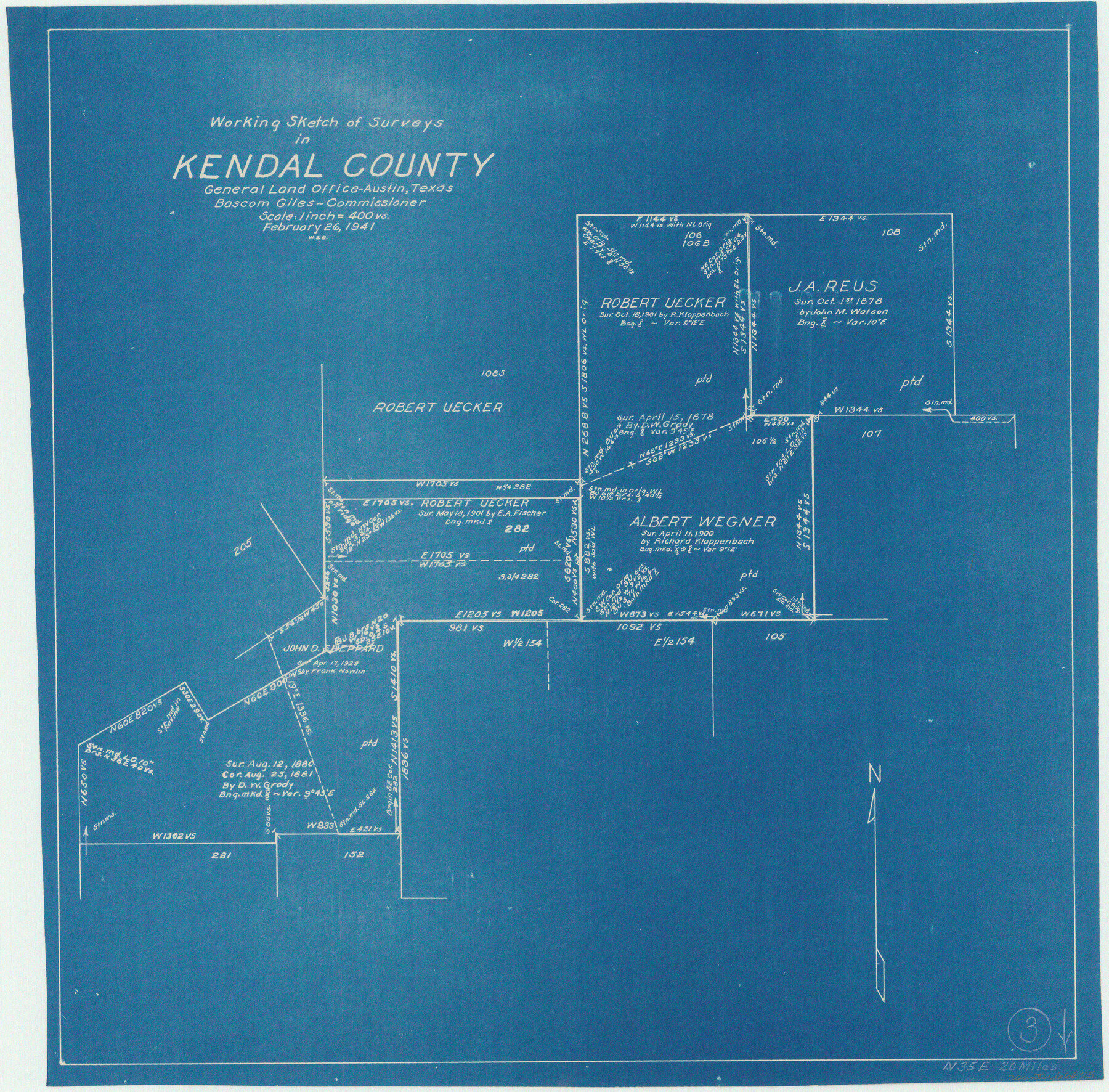
Kendall County Working Sketch 3
-
Map/Doc
66675
-
Collection
General Map Collection
-
Object Dates
2/26/1941 (Creation Date)
-
People and Organizations
W. S. Brewington (Draftsman)
-
Counties
Kendall
-
Subjects
Surveying Working Sketch
-
Height x Width
18.0 x 18.3 inches
45.7 x 46.5 cm
-
Scale
1" = 400 varas
Part of: General Map Collection
Map of New Brunswick and Nova Scotia / Map of Newfoundland / Map of the West Indies, Guatimala and part of Mexico to illustrate Olney's school geography

Print $20.00
- Digital $50.00
Map of New Brunswick and Nova Scotia / Map of Newfoundland / Map of the West Indies, Guatimala and part of Mexico to illustrate Olney's school geography
1844
Size 9.5 x 12.1 inches
Map/Doc 93544
Pecos County Rolled Sketch 22

Print $20.00
- Digital $50.00
Pecos County Rolled Sketch 22
1886
Size 24.3 x 37.0 inches
Map/Doc 93455
Dimmit County Rolled Sketch 9

Print $20.00
- Digital $50.00
Dimmit County Rolled Sketch 9
1941
Size 37.8 x 39.3 inches
Map/Doc 8796
Gaines County Rolled Sketch 23

Print $20.00
- Digital $50.00
Gaines County Rolled Sketch 23
1963
Size 24.6 x 37.1 inches
Map/Doc 5938
El Paso County Working Sketch 56

Print $40.00
- Digital $50.00
El Paso County Working Sketch 56
1971
Size 65.7 x 43.4 inches
Map/Doc 69078
Pecos County Rolled Sketch 22

Print $20.00
- Digital $50.00
Pecos County Rolled Sketch 22
1886
Size 22.4 x 36.8 inches
Map/Doc 93454
Newton County Working Sketch 8

Print $20.00
- Digital $50.00
Newton County Working Sketch 8
1937
Size 23.2 x 18.5 inches
Map/Doc 71254
Duval County Sketch File 68

Print $20.00
- Digital $50.00
Duval County Sketch File 68
Size 23.9 x 19.6 inches
Map/Doc 11407
Hudspeth County Sketch File 30

Print $8.00
- Digital $50.00
Hudspeth County Sketch File 30
1950
Size 11.3 x 8.8 inches
Map/Doc 26986
Harrison County Rolled Sketch 10

Print $20.00
- Digital $50.00
Harrison County Rolled Sketch 10
1956
Size 33.6 x 26.1 inches
Map/Doc 6153
Map and Profile of the Denison and Pacific Railway from Denison to Whitesboro

Print $40.00
- Digital $50.00
Map and Profile of the Denison and Pacific Railway from Denison to Whitesboro
1878
Size 42.5 x 57.5 inches
Map/Doc 64284
Flight Mission No. BRA-7M, Frame 189, Jefferson County

Print $20.00
- Digital $50.00
Flight Mission No. BRA-7M, Frame 189, Jefferson County
1953
Size 18.5 x 22.3 inches
Map/Doc 85557
You may also like
Map of Newton Co.

Print $20.00
- Digital $50.00
Map of Newton Co.
1918
Size 46.4 x 39.4 inches
Map/Doc 81987
Eastland County Boundary File 13

Print $68.00
- Digital $50.00
Eastland County Boundary File 13
Size 8.0 x 3.7 inches
Map/Doc 52785
Tyler County Sketch File 24

Print $16.00
- Digital $50.00
Tyler County Sketch File 24
1944
Size 11.2 x 9.0 inches
Map/Doc 38681
Tyler County Sketch File 3

Print $10.00
- Digital $50.00
Tyler County Sketch File 3
1855
Size 8.5 x 8.0 inches
Map/Doc 38622
Kaufman County Working Sketch 9

Print $20.00
- Digital $50.00
Kaufman County Working Sketch 9
1988
Size 35.9 x 29.8 inches
Map/Doc 66672
Flight Mission No. DQN-1K, Frame 81, Calhoun County

Print $20.00
- Digital $50.00
Flight Mission No. DQN-1K, Frame 81, Calhoun County
1953
Size 18.4 x 22.1 inches
Map/Doc 84166
Cottle County Rolled Sketch 13

Print $20.00
- Digital $50.00
Cottle County Rolled Sketch 13
1976
Size 21.6 x 35.5 inches
Map/Doc 5571
[Section 34, Block 194 G. C. & S. F.]
![91672, [Section 34, Block 194 G. C. & S. F.], Twichell Survey Records](https://historictexasmaps.com/wmedia_w700/maps/91672-1.tif.jpg)
Print $2.00
- Digital $50.00
[Section 34, Block 194 G. C. & S. F.]
1927
Size 7.5 x 5.9 inches
Map/Doc 91672
A Map of the Indian Territory, Northern Texas and New Mexico showing the [G]reat Western Prairies
![97127, A Map of the Indian Territory, Northern Texas and New Mexico showing the [G]reat Western Prairies, General Map Collection](https://historictexasmaps.com/wmedia_w700/97127.tif.jpg)
Print $20.00
- Digital $50.00
A Map of the Indian Territory, Northern Texas and New Mexico showing the [G]reat Western Prairies
1844
Size 15.0 x 16.0 inches
Map/Doc 97127
Map of Wichita County

Print $20.00
- Digital $50.00
Map of Wichita County
1874
Size 22.8 x 21.0 inches
Map/Doc 4142
[Neches River Bed, Plat and Calculations]
![77100, [Neches River Bed, Plat and Calculations], General Map Collection](https://historictexasmaps.com/wmedia_w700/maps/77100.tif.jpg)
Print $20.00
- Digital $50.00
[Neches River Bed, Plat and Calculations]
1928
Size 25.6 x 37.2 inches
Map/Doc 77100
Reagan County Rolled Sketch 38

Print $20.00
- Digital $50.00
Reagan County Rolled Sketch 38
1964
Size 39.2 x 40.5 inches
Map/Doc 9830