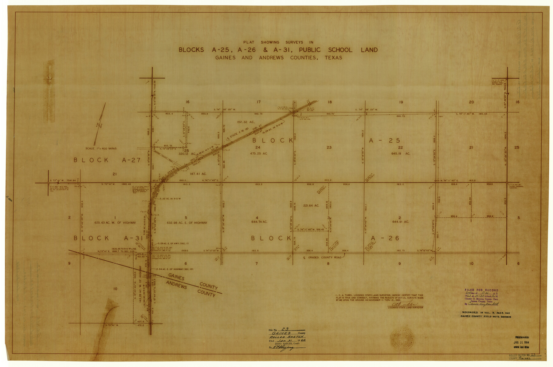
Gaines County Rolled Sketch 23
Plat showing surveys in Blocks A-25, A-26, & A-31, Public School Land
-
Map/Doc
5938
-
Collection
General Map Collection
-
Object Dates
11/21/1963 (Creation Date)
1/31/1964 (File Date)
-
People and Organizations
C.A. Tubbs (Surveyor/Engineer)
-
Counties
Gaines Andrews
-
Subjects
Surveying Rolled Sketch
-
Height x Width
24.6 x 37.1 inches
62.5 x 94.2 cm
-
Medium
van dyke/brownline/sepia
-
Scale
1" = 400 varas
Part of: General Map Collection
Flight Mission No. BRA-16M, Frame 95, Jefferson County

Print $20.00
- Digital $50.00
Flight Mission No. BRA-16M, Frame 95, Jefferson County
1953
Size 18.5 x 22.2 inches
Map/Doc 85707
Val Verde County Working Sketch 26

Print $20.00
- Digital $50.00
Val Verde County Working Sketch 26
1936
Size 22.9 x 31.5 inches
Map/Doc 72161
Map of the State University & Public School Lands in Reeves and El Paso Cos.

Print $40.00
- Digital $50.00
Map of the State University & Public School Lands in Reeves and El Paso Cos.
1884
Size 39.1 x 56.3 inches
Map/Doc 2434
Roberts County Working Sketch 1

Print $20.00
- Digital $50.00
Roberts County Working Sketch 1
1922
Size 17.6 x 17.7 inches
Map/Doc 63527
Coleman County Sketch File 29

Print $40.00
- Digital $50.00
Coleman County Sketch File 29
1873
Size 16.9 x 12.9 inches
Map/Doc 18718

Intracoastal Waterway in Texas - Corpus Christi to Point Isabel including Arroyo Colorado to Mo. Pac. R.R. Bridge Near Harlingen

Print $20.00
- Digital $50.00
Intracoastal Waterway in Texas - Corpus Christi to Point Isabel including Arroyo Colorado to Mo. Pac. R.R. Bridge Near Harlingen
1933
Size 40.9 x 27.8 inches
Map/Doc 61874
Atascosa County Working Sketch 30

Print $20.00
- Digital $50.00
Atascosa County Working Sketch 30
1980
Size 16.4 x 20.6 inches
Map/Doc 67226
Coleman County Sketch File 3a

Print $20.00
- Digital $50.00
Coleman County Sketch File 3a
1857
Size 12.6 x 19.2 inches
Map/Doc 11117
McLennan County Sketch File 30

Print $4.00
- Digital $50.00
McLennan County Sketch File 30
Size 8.4 x 7.4 inches
Map/Doc 31304
Jack County Working Sketch 7

Print $20.00
- Digital $50.00
Jack County Working Sketch 7
1953
Size 37.2 x 31.9 inches
Map/Doc 66433
Map of Brazoria

Print $20.00
- Digital $50.00
Map of Brazoria
1860
Size 19.8 x 26.7 inches
Map/Doc 856
You may also like
Geological Highway Map of Texas

Geological Highway Map of Texas
1973
Size 28.4 x 36.2 inches
Map/Doc 74356
Coleman County Sketch File 19

Print $4.00
- Digital $50.00
Coleman County Sketch File 19
Size 12.5 x 8.1 inches
Map/Doc 18692
Starr County Rolled Sketch 30

Print $20.00
- Digital $50.00
Starr County Rolled Sketch 30
1941
Size 14.9 x 21.5 inches
Map/Doc 7813
Flight Mission No. DCL-6C, Frame 132, Kenedy County

Print $20.00
- Digital $50.00
Flight Mission No. DCL-6C, Frame 132, Kenedy County
1943
Size 18.6 x 22.3 inches
Map/Doc 85962
Schleicher County Working Sketch 1

Print $20.00
- Digital $50.00
Schleicher County Working Sketch 1
1902
Size 14.8 x 17.4 inches
Map/Doc 63803
Brazoria County Sketch File 47

Print $10.00
- Digital $50.00
Brazoria County Sketch File 47
Size 14.3 x 8.9 inches
Map/Doc 15106
Llano County Sketch File 15

Print $2.00
- Digital $50.00
Llano County Sketch File 15
Size 10.4 x 7.7 inches
Map/Doc 30391
Working Sketch in Caldwell County

Print $20.00
- Digital $50.00
Working Sketch in Caldwell County
1922
Size 40.2 x 43.3 inches
Map/Doc 93035
Current Miscellaneous File 15

Print $16.00
- Digital $50.00
Current Miscellaneous File 15
1951
Size 10.7 x 8.2 inches
Map/Doc 73822
Webb County Sketch File 11a

Print $4.00
- Digital $50.00
Webb County Sketch File 11a
1883
Size 11.2 x 8.7 inches
Map/Doc 39779
Karte des Staates, Texas

Print $20.00
- Digital $50.00
Karte des Staates, Texas
1851
Size 25.5 x 30.8 inches
Map/Doc 2123
Hemphill County Rolled Sketch 4

Print $40.00
- Digital $50.00
Hemphill County Rolled Sketch 4
Size 29.7 x 55.1 inches
Map/Doc 6186