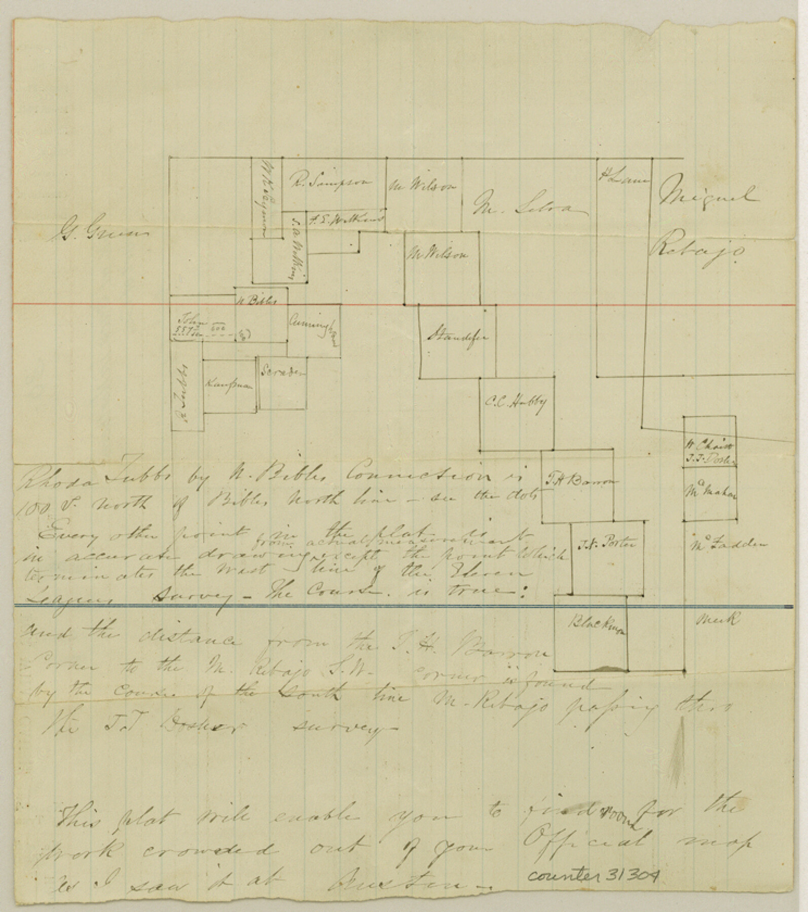
McLennan County Sketch File 30
[Sketch of surveys in western part of the county]
-
Map/Doc
31304
-
Collection
General Map Collection
-
Counties
McLennan
-
Subjects
Surveying Sketch File
-
Height x Width
8.4 x 7.4 inches
21.3 x 18.8 cm
-
Medium
paper, manuscript
Part of: General Map Collection
Flight Mission No. CRC-4R, Frame 92, Chambers County

Print $20.00
- Digital $50.00
Flight Mission No. CRC-4R, Frame 92, Chambers County
1956
Size 18.5 x 22.4 inches
Map/Doc 84889
Andrews County Rolled Sketch 17

Print $40.00
- Digital $50.00
Andrews County Rolled Sketch 17
1934
Size 30.9 x 48.9 inches
Map/Doc 8393
Harris County Historic Topographic 7

Print $20.00
- Digital $50.00
Harris County Historic Topographic 7
1916
Size 20.4 x 23.4 inches
Map/Doc 65817
Controlled Mosaic by Jack Amman Photogrammetric Engineers, Inc - Sheet 18

Print $20.00
- Digital $50.00
Controlled Mosaic by Jack Amman Photogrammetric Engineers, Inc - Sheet 18
1954
Size 19.4 x 24.0 inches
Map/Doc 83463
Amplissimae Regionis Mississipi seu Provinciae Ludovicianae a R.P. Ludovico Hennepin Francisc Miss in America Septentrionali Anno 1687. Detectae, Nunc Gallorum Coloniis et Actionum Negotiis Toto Orbe Celeberrimae

Print $20.00
- Digital $50.00
Amplissimae Regionis Mississipi seu Provinciae Ludovicianae a R.P. Ludovico Hennepin Francisc Miss in America Septentrionali Anno 1687. Detectae, Nunc Gallorum Coloniis et Actionum Negotiis Toto Orbe Celeberrimae
1720
Size 20.7 x 24.2 inches
Map/Doc 97516
Crockett County Working Sketch 10

Print $20.00
- Digital $50.00
Crockett County Working Sketch 10
1913
Size 23.5 x 21.6 inches
Map/Doc 68343
Lampasas County Boundary File 4a

Print $12.00
- Digital $50.00
Lampasas County Boundary File 4a
Size 12.8 x 8.2 inches
Map/Doc 56122
Sutton County Rolled Sketch 46

Print $20.00
- Digital $50.00
Sutton County Rolled Sketch 46
1929
Size 19.4 x 15.6 inches
Map/Doc 7887
Flight Mission No. CLL-3N, Frame 19, Willacy County

Print $20.00
- Digital $50.00
Flight Mission No. CLL-3N, Frame 19, Willacy County
1954
Size 18.4 x 22.1 inches
Map/Doc 87085
Mills County Working Sketch 23

Print $20.00
- Digital $50.00
Mills County Working Sketch 23
1985
Size 22.8 x 36.8 inches
Map/Doc 71053

Map of Polk Co.

Print $40.00
- Digital $50.00
Map of Polk Co.
1906
Size 52.0 x 43.0 inches
Map/Doc 16789
You may also like
Jeff Davis Co.

Print $20.00
- Digital $50.00
Jeff Davis Co.
1893
Size 27.4 x 47.9 inches
Map/Doc 66880
Hunt County Sketch File 27

Print $4.00
- Digital $50.00
Hunt County Sketch File 27
1860
Size 10.3 x 7.6 inches
Map/Doc 27126
Atascosa County Rolled Sketch 24

Print $20.00
- Digital $50.00
Atascosa County Rolled Sketch 24
Size 38.3 x 45.2 inches
Map/Doc 5101
Dallam County Boundary File 2

Print $18.00
- Digital $50.00
Dallam County Boundary File 2
Size 8.7 x 4.3 inches
Map/Doc 52053
Map of Spearman Lands

Print $20.00
- Digital $50.00
Map of Spearman Lands
Size 20.1 x 15.3 inches
Map/Doc 90791
Webb County Sketch File 11b-1

Print $20.00
- Digital $50.00
Webb County Sketch File 11b-1
1880
Size 21.7 x 19.3 inches
Map/Doc 12627
Irion County Sketch File 14

Print $8.00
- Digital $50.00
Irion County Sketch File 14
1949
Size 11.2 x 8.7 inches
Map/Doc 27486
[Block K5, Section 13]
![91451, [Block K5, Section 13], Twichell Survey Records](https://historictexasmaps.com/wmedia_w700/maps/91451-1.tif.jpg)
Print $3.00
- Digital $50.00
[Block K5, Section 13]
Size 11.4 x 10.4 inches
Map/Doc 91451
Flight Mission No. DCL-6C, Frame 28, Kenedy County

Print $20.00
- Digital $50.00
Flight Mission No. DCL-6C, Frame 28, Kenedy County
1943
Size 18.7 x 22.4 inches
Map/Doc 85885
Shelby County Sketch File 32

Print $20.00
- Digital $50.00
Shelby County Sketch File 32
1949
Size 23.4 x 17.7 inches
Map/Doc 12321
Flight Mission No. BRE-3P, Frame 35, Nueces County

Print $20.00
- Digital $50.00
Flight Mission No. BRE-3P, Frame 35, Nueces County
1956
Size 18.5 x 21.1 inches
Map/Doc 86813
Sulphur River, Harts Bluff Sheet

Print $3.00
- Digital $50.00
Sulphur River, Harts Bluff Sheet
1919
Size 13.1 x 18.0 inches
Map/Doc 78329