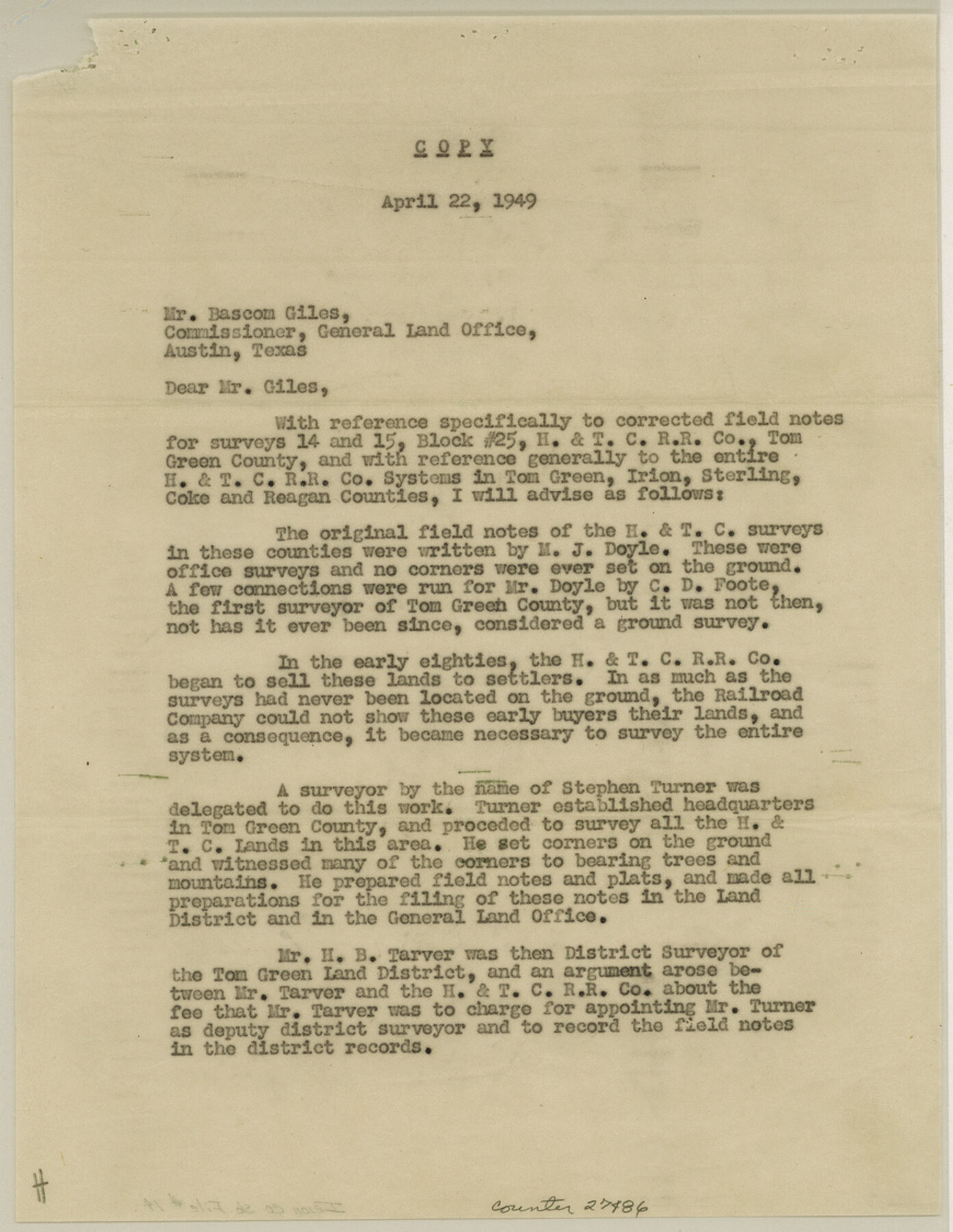
Irion County Sketch File 14
[Report regarding "Turner Corners"]
-
Map/Doc
27486
-
Collection
General Map Collection
-
Object Dates
1949/4/22 (Creation Date)
1949/4/28 (File Date)
-
People and Organizations
H.L. George (Surveyor/Engineer)
M.J. Doyle (Surveyor/Engineer)
C.D. Foote (Surveyor/Engineer)
Stephen Turner (Surveyor/Engineer)
J.J. Goodfellow (Surveyor/Engineer)
H.M. Garden (Surveyor/Engineer)
-
Counties
Irion Tom Green Sterling Coke Reagan
-
Subjects
Surveying Sketch File
-
Height x Width
11.2 x 8.7 inches
28.4 x 22.1 cm
-
Medium
paper, print
Part of: General Map Collection
Fort Bend County Working Sketch 15

Print $20.00
- Digital $50.00
Fort Bend County Working Sketch 15
1950
Size 22.5 x 14.7 inches
Map/Doc 69221
Hudspeth County Working Sketch 53-2

Print $40.00
- Digital $50.00
Hudspeth County Working Sketch 53-2
1988
Size 49.9 x 43.3 inches
Map/Doc 78210
Flight Mission No. DAH-9M, Frame 197, Orange County

Print $20.00
- Digital $50.00
Flight Mission No. DAH-9M, Frame 197, Orange County
1953
Size 18.5 x 22.4 inches
Map/Doc 86865
Burleson County Working Sketch 6

Print $20.00
- Digital $50.00
Burleson County Working Sketch 6
1980
Size 22.3 x 16.0 inches
Map/Doc 67725
Blanco County Sketch File 37

Print $4.00
- Digital $50.00
Blanco County Sketch File 37
Size 8.7 x 14.1 inches
Map/Doc 14646
Collingsworth County

Print $20.00
- Digital $50.00
Collingsworth County
Size 42.4 x 40.6 inches
Map/Doc 66778
Brazoria County Rolled Sketch 20

Print $20.00
- Digital $50.00
Brazoria County Rolled Sketch 20
1917
Size 31.1 x 47.1 inches
Map/Doc 8929
Jefferson County Sketch File 5b

Print $6.00
- Digital $50.00
Jefferson County Sketch File 5b
1860
Size 9.3 x 11.1 inches
Map/Doc 28108
Sulphur River, Terry Lake Sheet

Print $20.00
- Digital $50.00
Sulphur River, Terry Lake Sheet
1919
Size 15.7 x 18.3 inches
Map/Doc 78337
Loving County Rolled Sketch 7

Print $20.00
- Digital $50.00
Loving County Rolled Sketch 7
Size 24.1 x 28.4 inches
Map/Doc 7479
Hardin County Working Sketch 28

Print $20.00
- Digital $50.00
Hardin County Working Sketch 28
1956
Size 18.8 x 18.9 inches
Map/Doc 63426
Travis County State Real Property Sketch 18

Print $20.00
Travis County State Real Property Sketch 18
2005
Size 24.4 x 35.2 inches
Map/Doc 96976
You may also like
[Blocks C4, SI, and JK]
![90774, [Blocks C4, SI, and JK], Twichell Survey Records](https://historictexasmaps.com/wmedia_w700/maps/90774-1.tif.jpg)
Print $20.00
- Digital $50.00
[Blocks C4, SI, and JK]
Size 16.1 x 16.3 inches
Map/Doc 90774
Gray County Sketch File 7c

Print $20.00
- Digital $50.00
Gray County Sketch File 7c
1885
Size 26.5 x 19.6 inches
Map/Doc 11576
Johnson County Working Sketch 34

Print $20.00
- Digital $50.00
Johnson County Working Sketch 34
2008
Size 20.0 x 21.2 inches
Map/Doc 88890
Denton County, Texas

Print $20.00
- Digital $50.00
Denton County, Texas
1870
Size 18.6 x 22.7 inches
Map/Doc 723
Hunt County Sketch File A

Print $4.00
- Digital $50.00
Hunt County Sketch File A
1884
Size 14.4 x 8.3 inches
Map/Doc 27170
International Boundary Line in the Rio Grande delineated in accordance with the Treaty of 1970 - (1982/1983 Aerial Photographs)

International Boundary Line in the Rio Grande delineated in accordance with the Treaty of 1970 - (1982/1983 Aerial Photographs)
1982
Map/Doc 74827
El Nuevo Mexico y Tierras Adyacentes Mapa Levantado para la demarcacion de los Limites de los Dominios Españoles y de los Estados Unidos por el P.D. Jose Pichardo quien lo dedica al Exmo. Sor. D. Fracisco Xavier Venegas Virrey de esta N.E. &. Año de 1811

Print $40.00
El Nuevo Mexico y Tierras Adyacentes Mapa Levantado para la demarcacion de los Limites de los Dominios Españoles y de los Estados Unidos por el P.D. Jose Pichardo quien lo dedica al Exmo. Sor. D. Fracisco Xavier Venegas Virrey de esta N.E. &. Año de 1811
1811
Size 35.8 x 49.6 inches
Map/Doc 95360
[Elwood Ranch Field Notes]
![91090, [Elwood Ranch Field Notes], Twichell Survey Records](https://historictexasmaps.com/wmedia_w700/maps/91090-1.tif.jpg)
Print $20.00
- Digital $50.00
[Elwood Ranch Field Notes]
Size 12.4 x 16.4 inches
Map/Doc 91090
Wood County Rolled Sketch 7

Print $20.00
- Digital $50.00
Wood County Rolled Sketch 7
Size 31.9 x 26.9 inches
Map/Doc 8285
[Sketch for Mineral Application 13439 - Old River, Walle Merritt]
![65688, [Sketch for Mineral Application 13439 - Old River, Walle Merritt], General Map Collection](https://historictexasmaps.com/wmedia_w700/maps/65688-1.tif.jpg)
Print $20.00
- Digital $50.00
[Sketch for Mineral Application 13439 - Old River, Walle Merritt]
1925
Size 41.2 x 18.9 inches
Map/Doc 65688
Hidalgo County Sketch File 11

Print $40.00
- Digital $50.00
Hidalgo County Sketch File 11
1908
Size 18.5 x 13.6 inches
Map/Doc 26429