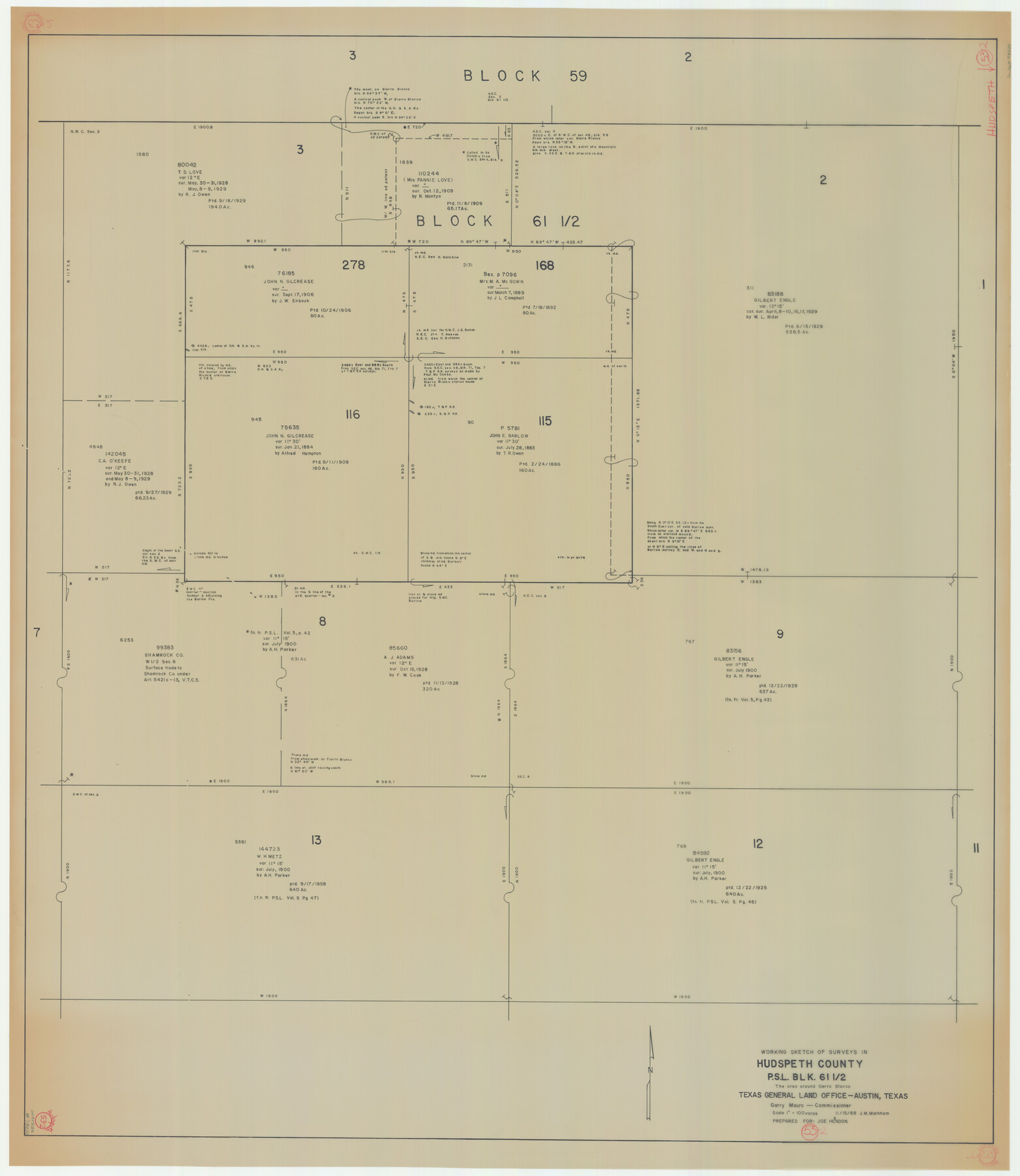
Hudspeth County Working Sketch 53-2
-
Map/Doc
78210
-
Collection
General Map Collection
-
Object Dates
11/15/1988 (Creation Date)
-
People and Organizations
J.M. Markham (Draftsman)
-
Counties
Hudspeth
-
Subjects
Surveying Working Sketch
-
Height x Width
49.9 x 43.3 inches
126.8 x 110.0 cm
-
Scale
1" = 100 varas
Part of: General Map Collection
Flight Mission No. BRE-1P, Frame 58, Nueces County

Print $20.00
- Digital $50.00
Flight Mission No. BRE-1P, Frame 58, Nueces County
1956
Size 18.5 x 22.2 inches
Map/Doc 86647
Delta County Sketch File 3

Print $6.00
- Digital $50.00
Delta County Sketch File 3
Size 10.2 x 12.6 inches
Map/Doc 20672
Brewster County Rolled Sketch 126

Print $225.00
- Digital $50.00
Brewster County Rolled Sketch 126
1908
Map/Doc 43230
Foard County Sketch File 37

Print $4.00
- Digital $50.00
Foard County Sketch File 37
1891
Size 11.2 x 9.1 inches
Map/Doc 22869
Haskell County

Print $20.00
- Digital $50.00
Haskell County
1873
Size 20.1 x 24.2 inches
Map/Doc 3642
Brown County Rolled Sketch 2A

Print $20.00
- Digital $50.00
Brown County Rolled Sketch 2A
1984
Size 25.6 x 37.4 inches
Map/Doc 5350
Webb County Working Sketch 37

Print $20.00
- Digital $50.00
Webb County Working Sketch 37
1940
Size 25.0 x 20.4 inches
Map/Doc 72402
Map of the New England or Eastern States (Inset 1: Map of New Brunswick, Nova Scotia and Newfoundland / Inset 2: Vicinity of Boston and Providence / Inset 3: Vicinity of New Haven and Hartford)

Print $20.00
- Digital $50.00
Map of the New England or Eastern States (Inset 1: Map of New Brunswick, Nova Scotia and Newfoundland / Inset 2: Vicinity of Boston and Providence / Inset 3: Vicinity of New Haven and Hartford)
1844
Size 17.8 x 11.8 inches
Map/Doc 93495
Culberson County Rolled Sketch 54

Print $40.00
- Digital $50.00
Culberson County Rolled Sketch 54
1968
Size 59.0 x 29.4 inches
Map/Doc 10300
Map of Comanche County

Print $20.00
- Digital $50.00
Map of Comanche County
1856
Size 22.5 x 29.8 inches
Map/Doc 3432
Crockett County Sketch File 24

Print $10.00
- Digital $50.00
Crockett County Sketch File 24
1881
Size 13.1 x 8.6 inches
Map/Doc 19698
Harris County Rolled Sketch 96B

Print $20.00
- Digital $50.00
Harris County Rolled Sketch 96B
Size 15.8 x 15.6 inches
Map/Doc 10681
You may also like
Map of Falls County

Print $20.00
- Digital $50.00
Map of Falls County
1874
Size 19.8 x 22.6 inches
Map/Doc 3530
[Plat of the Town of Lockhart]
![82534, [Plat of the Town of Lockhart], General Map Collection](https://historictexasmaps.com/wmedia_w700/maps/82534-1.tif.jpg)
Print $20.00
- Digital $50.00
[Plat of the Town of Lockhart]
Size 19.5 x 25.0 inches
Map/Doc 82534
Presidio County Working Sketch 27

Print $20.00
- Digital $50.00
Presidio County Working Sketch 27
1945
Size 32.4 x 13.4 inches
Map/Doc 71703
Chart of soundings through the different channels in Aransas and Matagorda Bays as taken in 1855 by Capt. R. B. Marey, U. S. A. [Inset: Harbour of Lamar and Live-Oak Pt.]
![72977, Chart of soundings through the different channels in Aransas and Matagorda Bays as taken in 1855 by Capt. R. B. Marey, U. S. A. [Inset: Harbour of Lamar and Live-Oak Pt.], General Map Collection](https://historictexasmaps.com/wmedia_w700/maps/72977.tif.jpg)
Print $20.00
- Digital $50.00
Chart of soundings through the different channels in Aransas and Matagorda Bays as taken in 1855 by Capt. R. B. Marey, U. S. A. [Inset: Harbour of Lamar and Live-Oak Pt.]
Size 28.1 x 18.2 inches
Map/Doc 72977
Capitol Land and Investment Company's List of Texas Lands

Capitol Land and Investment Company's List of Texas Lands
1907
Size 7.9 x 5.2 inches
Map/Doc 97052
Armstrong County Boundary File 1 and 1a

Print $10.00
- Digital $50.00
Armstrong County Boundary File 1 and 1a
Size 9.0 x 8.1 inches
Map/Doc 50121

Reeves County Working Sketch 4a

Print $20.00
- Digital $50.00
Reeves County Working Sketch 4a
1933
Size 26.0 x 34.6 inches
Map/Doc 63447
Lamar County Rolled Sketch 1

Print $40.00
- Digital $50.00
Lamar County Rolled Sketch 1
1989
Size 50.3 x 39.1 inches
Map/Doc 9553
Brewster County Working Sketch 118.2

Print $20.00
- Digital $50.00
Brewster County Working Sketch 118.2
Size 26.8 x 20.6 inches
Map/Doc 67871
Flight Mission No. CGI-3N, Frame 177, Cameron County

Print $20.00
- Digital $50.00
Flight Mission No. CGI-3N, Frame 177, Cameron County
1954
Size 18.5 x 22.3 inches
Map/Doc 84641
W. M. Kuykendall Ranch, Matagorda County, Texas

Print $20.00
- Digital $50.00
W. M. Kuykendall Ranch, Matagorda County, Texas
1926
Size 24.3 x 39.6 inches
Map/Doc 3028