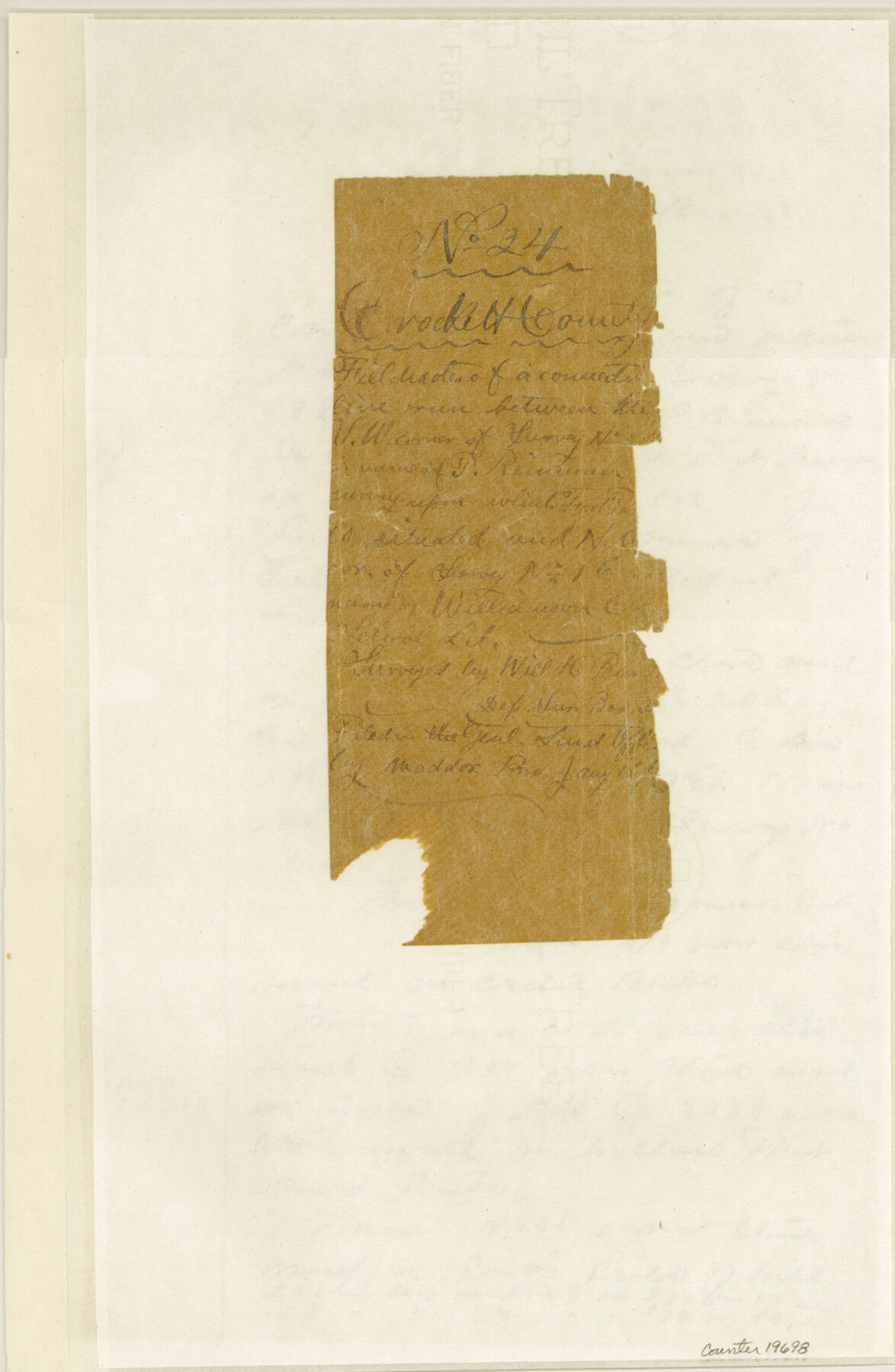
Crockett County Sketch File 24
[Connecting line from southwest corner of survey 538 to northeast corner of survey 16, Williamson County School Land]
-
Map/Doc
19698
-
Collection
General Map Collection
-
Object Dates
1881/1/16 (Creation Date)
1881/1/16 (File Date)
1881 (Survey Date)
-
People and Organizations
W.H. Bonnell (Surveyor/Engineer)
Alex Wilson (Chainman)
Sam Merks (Chainman)
-
Counties
Crockett
-
Subjects
Surveying Sketch File
-
Height x Width
13.1 x 8.6 inches
33.3 x 21.8 cm
-
Medium
paper, manuscript
-
Features
Fort Terrell
Hollow Creek
North Llano River
Part of: General Map Collection
Hardeman County Sketch File A2

Print $20.00
- Digital $50.00
Hardeman County Sketch File A2
Size 28.5 x 17.3 inches
Map/Doc 11631
Greater Austin, Texas Streetmap

Greater Austin, Texas Streetmap
Size 45.8 x 36.2 inches
Map/Doc 94431
Pecos County Working Sketch 34

Print $20.00
- Digital $50.00
Pecos County Working Sketch 34
1939
Size 32.7 x 27.6 inches
Map/Doc 71506
Flight Mission No. BRA-16M, Frame 83, Jefferson County

Print $20.00
- Digital $50.00
Flight Mission No. BRA-16M, Frame 83, Jefferson County
1953
Size 18.5 x 22.3 inches
Map/Doc 85695
Upton County Working Sketch 56

Print $20.00
- Digital $50.00
Upton County Working Sketch 56
1985
Size 43.9 x 43.8 inches
Map/Doc 69553
Angelina County Sketch File 17a

Print $8.00
- Digital $50.00
Angelina County Sketch File 17a
1863
Size 13.1 x 8.2 inches
Map/Doc 13024
Foard County Aerial Photograph Index Sheet 3

Print $20.00
- Digital $50.00
Foard County Aerial Photograph Index Sheet 3
1950
Size 20.3 x 18.9 inches
Map/Doc 83690
[Edwards County]
![4939, [Edwards County], General Map Collection](https://historictexasmaps.com/wmedia_w700/maps/4939-1.tif.jpg)
Print $40.00
- Digital $50.00
[Edwards County]
1900
Size 48.6 x 32.4 inches
Map/Doc 4939
Township No. 2 South Range No. 19 West of the Indian Meridian

Print $20.00
- Digital $50.00
Township No. 2 South Range No. 19 West of the Indian Meridian
1875
Size 19.2 x 24.8 inches
Map/Doc 75181
Traced from Genl. Arista's map captured by the American Army under Genl. Taylor at Resaca de la Palma 9th May '46 and presented to James K. Polk, President U. States

Print $20.00
- Digital $50.00
Traced from Genl. Arista's map captured by the American Army under Genl. Taylor at Resaca de la Palma 9th May '46 and presented to James K. Polk, President U. States
1846
Size 18.2 x 27.4 inches
Map/Doc 73061
Webb County Sketch File 13-1

Print $6.00
- Digital $50.00
Webb County Sketch File 13-1
Size 8.5 x 7.8 inches
Map/Doc 39804
Archer County Sketch File 25

Print $40.00
- Digital $50.00
Archer County Sketch File 25
Size 22.3 x 46.6 inches
Map/Doc 10348
You may also like
Map of Texas Compiled from surveys on record in the General Land Office of the Republic to the year 1839

Print $20.00
- Digital $50.00
Map of Texas Compiled from surveys on record in the General Land Office of the Republic to the year 1839
1891
Size 36.6 x 25.7 inches
Map/Doc 1891

Hays County Working Sketch 12

Print $20.00
- Digital $50.00
Hays County Working Sketch 12
1950
Size 22.8 x 24.3 inches
Map/Doc 66086
The North Coast of the Gulf of Mexico from St. Marks to Galveston

Print $20.00
- Digital $50.00
The North Coast of the Gulf of Mexico from St. Marks to Galveston
1844
Size 27.5 x 41.1 inches
Map/Doc 97396
Map of Callahan Co[unty]
![88916, Map of Callahan Co[unty], Library of Congress](https://historictexasmaps.com/wmedia_w700/maps/88916.tif.jpg)
Print $20.00
Map of Callahan Co[unty]
1879
Size 24.7 x 18.5 inches
Map/Doc 88916
Navarro County Sketch File 17

Print $4.00
- Digital $50.00
Navarro County Sketch File 17
Size 12.8 x 8.4 inches
Map/Doc 32333
Zavala County Sketch File 49

Print $10.00
- Digital $50.00
Zavala County Sketch File 49
1955
Size 14.5 x 9.1 inches
Map/Doc 41441
Henderson County Working Sketch 7

Print $20.00
- Digital $50.00
Henderson County Working Sketch 7
1922
Size 12.5 x 18.8 inches
Map/Doc 66140
Map of Portion of the Gulf of Mexico Adjoining Jefferson County Showing Subdivision Thereof for Mineral Development

Print $20.00
- Digital $50.00
Map of Portion of the Gulf of Mexico Adjoining Jefferson County Showing Subdivision Thereof for Mineral Development
1937
Size 20.5 x 39.0 inches
Map/Doc 3020
Harris County Sketch File 92

Print $20.00
- Digital $50.00
Harris County Sketch File 92
1932
Size 37.9 x 35.0 inches
Map/Doc 10483
[West half of County]
![93188, [West half of County], Twichell Survey Records](https://historictexasmaps.com/wmedia_w700/maps/93188-1.tif.jpg)
Print $40.00
- Digital $50.00
[West half of County]
1914
Size 38.7 x 97.9 inches
Map/Doc 93188
Flight Mission No. BRA-16M, Frame 140, Jefferson County

Print $20.00
- Digital $50.00
Flight Mission No. BRA-16M, Frame 140, Jefferson County
1953
Size 18.6 x 22.2 inches
Map/Doc 85746