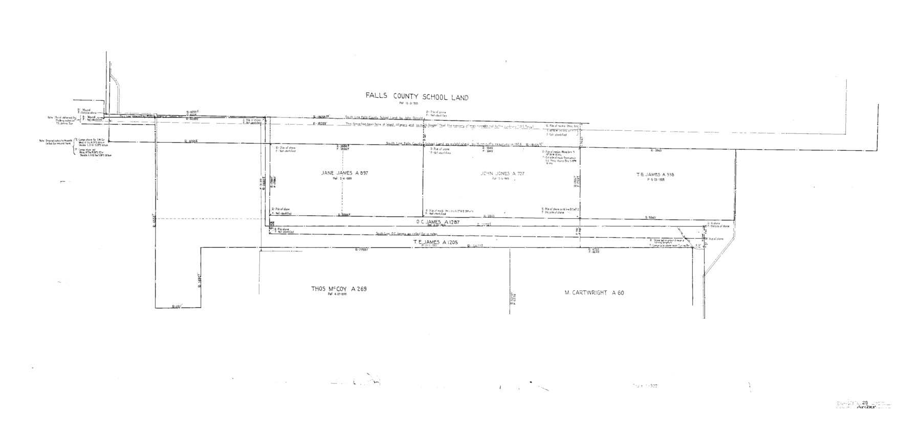
Archer County Sketch File 25
[Sketch of area south of Falls County School Land]
-
Map/Doc
10348
-
Collection
General Map Collection
-
People and Organizations
B. Smettem (Surveyor/Engineer)
-
Counties
Archer
-
Subjects
Surveying Sketch File
-
Height x Width
22.3 x 46.6 inches
56.6 x 118.4 cm
-
Medium
photostat
Part of: General Map Collection

Fort Bend County
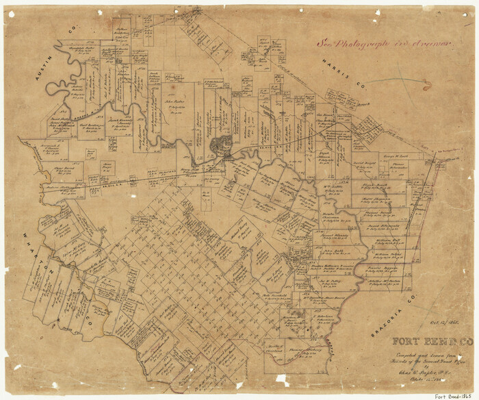
Print $20.00
- Digital $50.00
Fort Bend County
1865
Size 18.2 x 21.8 inches
Map/Doc 3550
Old Miscellaneous File 33

Print $4.00
- Digital $50.00
Old Miscellaneous File 33
1874
Size 9.8 x 8.1 inches
Map/Doc 75753
Maverick County Working Sketch Graphic Index

Print $20.00
- Digital $50.00
Maverick County Working Sketch Graphic Index
1947
Size 46.4 x 30.3 inches
Map/Doc 76635
Hutchinson County Working Sketch 5

Print $20.00
- Digital $50.00
Hutchinson County Working Sketch 5
1912
Size 16.0 x 11.4 inches
Map/Doc 66363
Williamson County Sketch File 6

Print $4.00
- Digital $50.00
Williamson County Sketch File 6
1848
Size 12.8 x 8.1 inches
Map/Doc 40314
Webb County Rolled Sketch 22

Print $40.00
- Digital $50.00
Webb County Rolled Sketch 22
Size 108.0 x 43.7 inches
Map/Doc 10120
Flight Mission No. CUG-3P, Frame 17, Kleberg County

Print $20.00
- Digital $50.00
Flight Mission No. CUG-3P, Frame 17, Kleberg County
1956
Size 18.6 x 22.3 inches
Map/Doc 86227
Frio County Working Sketch 20

Print $20.00
- Digital $50.00
Frio County Working Sketch 20
1985
Size 36.3 x 36.0 inches
Map/Doc 69294
Clay County Sketch File 38

Print $4.00
- Digital $50.00
Clay County Sketch File 38
Size 16.4 x 25.0 inches
Map/Doc 11092
Hutchinson County Rolled Sketch 28

Print $20.00
- Digital $50.00
Hutchinson County Rolled Sketch 28
1921
Size 28.1 x 34.7 inches
Map/Doc 6290
Mason County Sketch File 4

Print $6.00
- Digital $50.00
Mason County Sketch File 4
1875
Size 12.9 x 8.0 inches
Map/Doc 30684
You may also like
Harris County Historic Topographic 23

Print $20.00
- Digital $50.00
Harris County Historic Topographic 23
1916
Size 29.2 x 22.6 inches
Map/Doc 65834
McLennan County

Print $20.00
- Digital $50.00
McLennan County
1946
Size 42.3 x 45.1 inches
Map/Doc 77362
[J. Poitevent Block 2, T. T. RR. Block 2, C. C. Slaughter Block 1]
![90624, [J. Poitevent Block 2, T. T. RR. Block 2, C. C. Slaughter Block 1], Twichell Survey Records](https://historictexasmaps.com/wmedia_w700/maps/90624-1.tif.jpg)
Print $2.00
- Digital $50.00
[J. Poitevent Block 2, T. T. RR. Block 2, C. C. Slaughter Block 1]
Size 8.5 x 11.6 inches
Map/Doc 90624
Comanche County Working Sketch 20

Print $20.00
- Digital $50.00
Comanche County Working Sketch 20
1973
Size 20.5 x 15.6 inches
Map/Doc 68154
Flight Mission No. DCL-7C, Frame 56, Kenedy County

Print $20.00
- Digital $50.00
Flight Mission No. DCL-7C, Frame 56, Kenedy County
1943
Size 15.4 x 15.2 inches
Map/Doc 86044
[Sketch of area just south of Levi Pruitt survey]
![91854, [Sketch of area just south of Levi Pruitt survey], Twichell Survey Records](https://historictexasmaps.com/wmedia_w700/maps/91854-1.tif.jpg)
Print $20.00
- Digital $50.00
[Sketch of area just south of Levi Pruitt survey]
Size 24.9 x 18.6 inches
Map/Doc 91854
Map of Defunct and Ghost Counties in Texas

Print $20.00
- Digital $50.00
Map of Defunct and Ghost Counties in Texas
1939
Size 17.4 x 18.6 inches
Map/Doc 4805

Willacy County Boundary File 1

Print $23.00
- Digital $50.00
Willacy County Boundary File 1
Size 11.3 x 8.8 inches
Map/Doc 59956
Guadalupe County Sketch File 2

Print $4.00
- Digital $50.00
Guadalupe County Sketch File 2
1848
Size 9.4 x 8.3 inches
Map/Doc 24648
Boundary Between the United States & Mexico Agreed upon by the Joint Commission under the Treaty of Guadalupe Hidalgo

Print $4.00
- Digital $50.00
Boundary Between the United States & Mexico Agreed upon by the Joint Commission under the Treaty of Guadalupe Hidalgo
1853
Size 18.3 x 26.8 inches
Map/Doc 72881
McCulloch County Rolled Sketch 8

Print $40.00
- Digital $50.00
McCulloch County Rolled Sketch 8
1982
Size 51.3 x 31.4 inches
Map/Doc 10292