Hutchinson County Rolled Sketch 28
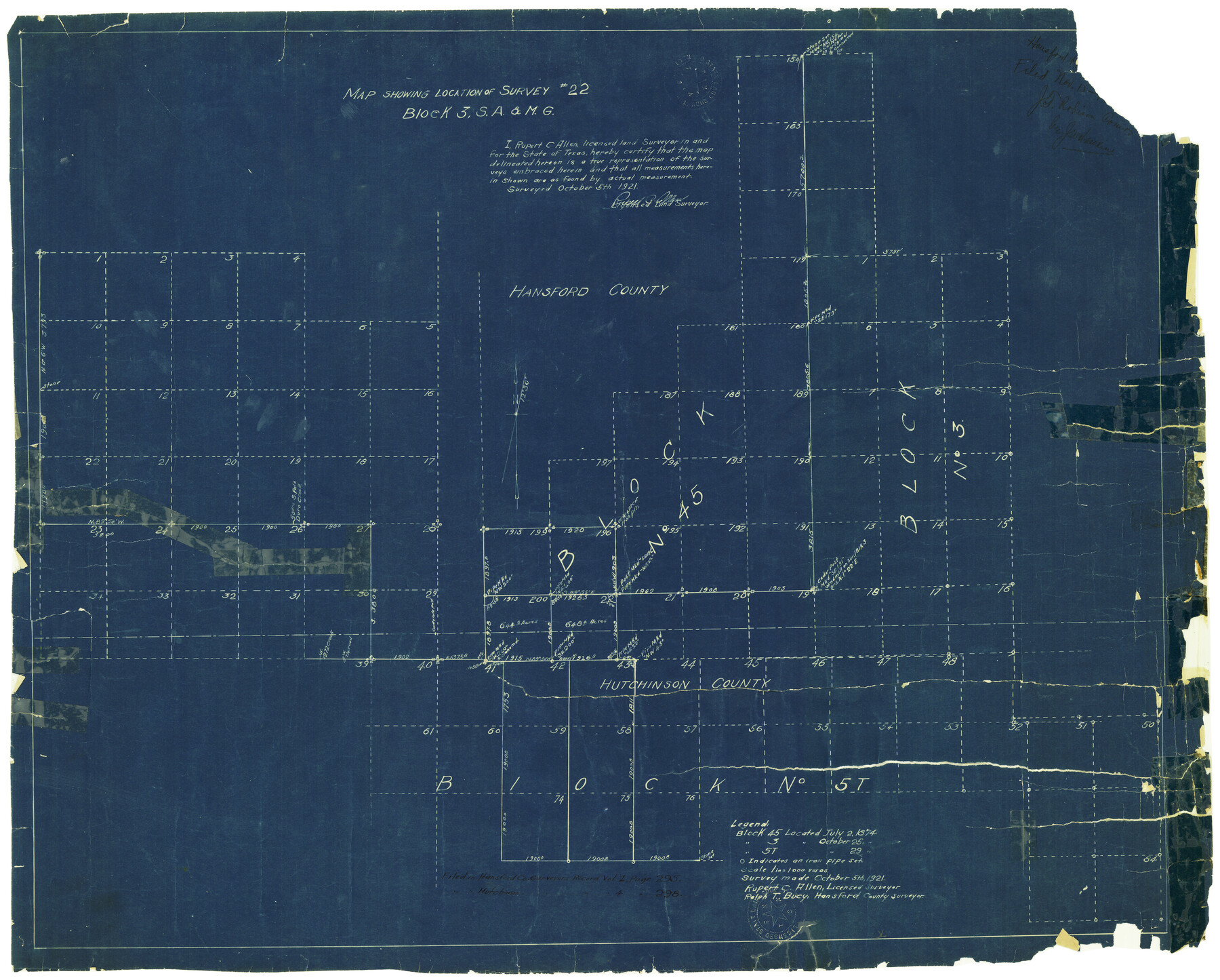
Map showing location of survey # 22, Block 3, S. A. & M. G.
-
Map/Doc
6290
-
Collection
General Map Collection
-
Object Dates
10/5/1921 (Creation Date)
11/15/1921 (File Date)
-
People and Organizations
Rupert C. Allen (Surveyor/Engineer)
-
Counties
Hutchinson
-
Subjects
Surveying Rolled Sketch
-
Height x Width
28.1 x 34.7 inches
71.4 x 88.1 cm
-
Medium
blueprint/diazo
Part of: General Map Collection
Crockett County Rolled Sketch 84

Print $20.00
- Digital $50.00
Crockett County Rolled Sketch 84
1961
Size 31.9 x 25.2 inches
Map/Doc 5624
Flight Mission No. CLL-3N, Frame 9, Willacy County

Print $20.00
- Digital $50.00
Flight Mission No. CLL-3N, Frame 9, Willacy County
1954
Size 18.5 x 22.3 inches
Map/Doc 87075
Dickens County Sketch File D2

Print $44.00
- Digital $50.00
Dickens County Sketch File D2
Size 27.2 x 19.1 inches
Map/Doc 20839
Pecos County Working Sketch 78

Print $20.00
- Digital $50.00
Pecos County Working Sketch 78
1960
Size 29.4 x 34.4 inches
Map/Doc 71550
Edwards County Sketch File 37

Print $4.00
- Digital $50.00
Edwards County Sketch File 37
1926
Size 11.3 x 9.0 inches
Map/Doc 21771
[Surveys in the Bexar District along the Balcones, Cibolo and Leon Creeks]
![63, [Surveys in the Bexar District along the Balcones, Cibolo and Leon Creeks], General Map Collection](https://historictexasmaps.com/wmedia_w700/maps/63.tif.jpg)
Print $3.00
- Digital $50.00
[Surveys in the Bexar District along the Balcones, Cibolo and Leon Creeks]
1842
Size 10.6 x 12.4 inches
Map/Doc 63
Flight Mission No. BRE-4P, Frame 169, Nueces County

Print $20.00
- Digital $50.00
Flight Mission No. BRE-4P, Frame 169, Nueces County
1956
Size 18.5 x 22.6 inches
Map/Doc 86832
[Surveys in Mills, Hamilton, Coryell and Bell Counties]
![78362, [Surveys in Mills, Hamilton, Coryell and Bell Counties], General Map Collection](https://historictexasmaps.com/wmedia_w700/maps/78362.tif.jpg)
Print $20.00
- Digital $50.00
[Surveys in Mills, Hamilton, Coryell and Bell Counties]
Size 33.9 x 19.5 inches
Map/Doc 78362
San Patricio County Rolled Sketch 31

Print $20.00
- Digital $50.00
San Patricio County Rolled Sketch 31
1941
Size 43.1 x 42.6 inches
Map/Doc 9898
Newton County Working Sketch 21

Print $20.00
- Digital $50.00
Newton County Working Sketch 21
1952
Size 27.5 x 32.5 inches
Map/Doc 71267
Sherman County

Print $20.00
- Digital $50.00
Sherman County
1932
Size 39.6 x 36.4 inches
Map/Doc 77422

You may also like
DeWitt County Working Sketch 16

Print $20.00
- Digital $50.00
DeWitt County Working Sketch 16
1920
Size 23.0 x 25.1 inches
Map/Doc 69016
Crockett County Sketch File 90

Print $40.00
- Digital $50.00
Crockett County Sketch File 90
1961
Size 14.7 x 23.5 inches
Map/Doc 11238
General Highway Map. Detail of Cities and Towns in Fort Bend County, Texas

Print $20.00
General Highway Map. Detail of Cities and Towns in Fort Bend County, Texas
1961
Size 18.1 x 24.5 inches
Map/Doc 79470
Mason County Sketch File 3a

Print $4.00
- Digital $50.00
Mason County Sketch File 3a
1877
Size 8.3 x 7.9 inches
Map/Doc 30682
Knox County Boundary File 6

Print $4.00
- Digital $50.00
Knox County Boundary File 6
Size 11.4 x 8.7 inches
Map/Doc 65049
Concho County Working Sketch 5

Print $20.00
- Digital $50.00
Concho County Working Sketch 5
1948
Size 41.3 x 37.9 inches
Map/Doc 68187
Part of a map showing resurvey of Capitol Leagues by R. S. Hunnicutt & Behn Cook State Surveyors

Print $20.00
- Digital $50.00
Part of a map showing resurvey of Capitol Leagues by R. S. Hunnicutt & Behn Cook State Surveyors
Size 22.2 x 17.6 inches
Map/Doc 90276
Timely Tips to Texas Truckers

Timely Tips to Texas Truckers
1906
Size 9.3 x 6.2 inches
Map/Doc 96609
General Highway Map, Cochran County, Texas

Print $20.00
General Highway Map, Cochran County, Texas
1940
Size 25.2 x 18.5 inches
Map/Doc 79048
A Plat of 23 Miles of the Colorado River
![65651, [Sketch for Mineral Application 1742], General Map Collection](https://historictexasmaps.com/wmedia_w700/maps/65651.tif.jpg)
Print $40.00
- Digital $50.00
A Plat of 23 Miles of the Colorado River
1918
Size 38.3 x 56.7 inches
Map/Doc 65651
Controlled Mosaic by Jack Amman Photogrammetric Engineers, Inc - Sheet 50

Print $20.00
- Digital $50.00
Controlled Mosaic by Jack Amman Photogrammetric Engineers, Inc - Sheet 50
1954
Size 20.0 x 24.0 inches
Map/Doc 83509
Lampasas County Working Sketch 14

Print $20.00
- Digital $50.00
Lampasas County Working Sketch 14
1974
Size 23.4 x 21.8 inches
Map/Doc 70291