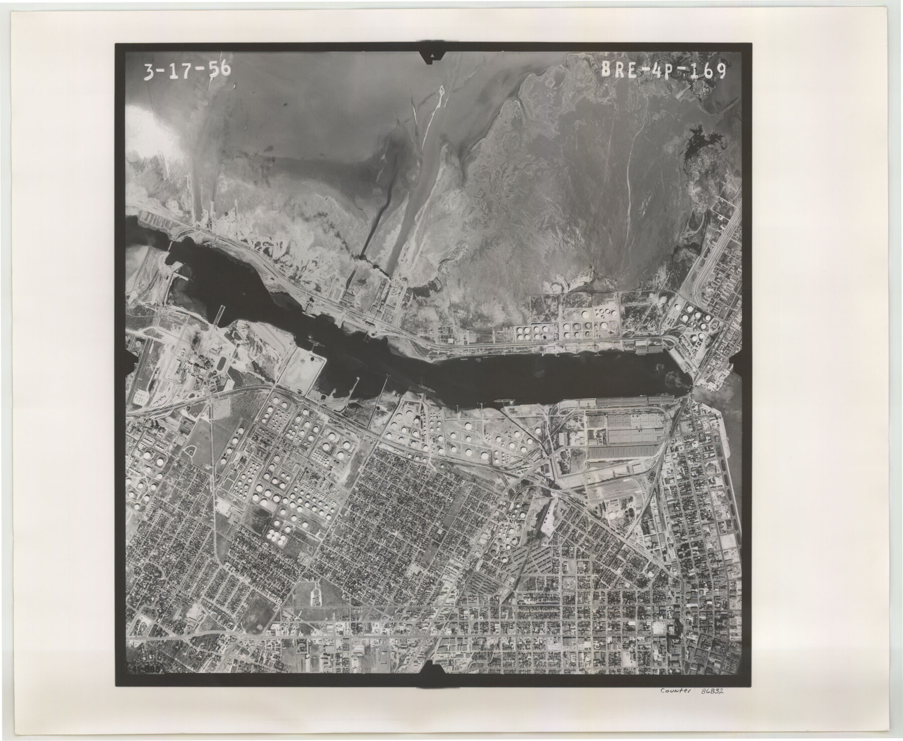
Flight Mission No. BRE-4P, Frame 169, Nueces County
BRE-4P-169
-
Map/Doc
86832
-
Collection
General Map Collection
-
Object Dates
1956/3/17 (Creation Date)
-
People and Organizations
U. S. Department of Agriculture (Publisher)
-
Counties
Nueces
-
Subjects
Aerial Photograph
-
Height x Width
18.5 x 22.6 inches
47.0 x 57.4 cm
-
Comments
Flown by V. L. Beavers and Associates of San Antonio, Texas.
Part of: General Map Collection
Coleman County

Print $40.00
- Digital $50.00
Coleman County
1945
Size 55.7 x 37.1 inches
Map/Doc 95458
Travis County Working Sketch 37

Print $20.00
- Digital $50.00
Travis County Working Sketch 37
1968
Size 12.5 x 12.1 inches
Map/Doc 69421
Oldham County Sketch File 18

Print $6.00
- Digital $50.00
Oldham County Sketch File 18
1910
Size 8.9 x 8.5 inches
Map/Doc 33272
Milam County Rolled Sketch 5

Print $20.00
- Digital $50.00
Milam County Rolled Sketch 5
Size 27.9 x 39.8 inches
Map/Doc 6777
El Paso County Working Sketch 10

Print $20.00
- Digital $50.00
El Paso County Working Sketch 10
1955
Size 31.1 x 20.5 inches
Map/Doc 69032
Crockett County Working Sketch 8

Print $20.00
- Digital $50.00
Crockett County Working Sketch 8
1903
Size 15.2 x 30.3 inches
Map/Doc 68341
Map of the Southwestern and part of the Western States to illustrate Olney's school geography

Print $20.00
- Digital $50.00
Map of the Southwestern and part of the Western States to illustrate Olney's school geography
1844
Size 19.0 x 12.1 inches
Map/Doc 93541
Maverick County Working Sketch 1

Print $20.00
- Digital $50.00
Maverick County Working Sketch 1
1906
Size 11.5 x 11.1 inches
Map/Doc 70893
Zavala County Rolled Sketch 14

Print $20.00
- Digital $50.00
Zavala County Rolled Sketch 14
1887
Size 28.1 x 40.8 inches
Map/Doc 10175
Carson County Boundary File 8

Print $40.00
- Digital $50.00
Carson County Boundary File 8
Size 7.8 x 35.0 inches
Map/Doc 51171
Sabine County Working Sketch 12

Print $20.00
- Digital $50.00
Sabine County Working Sketch 12
1935
Size 39.2 x 45.9 inches
Map/Doc 63683
Flight Mission No. DCL-6C, Frame 13, Kenedy County

Print $20.00
- Digital $50.00
Flight Mission No. DCL-6C, Frame 13, Kenedy County
1943
Size 18.6 x 22.3 inches
Map/Doc 85870
You may also like
Kimble County Working Sketch 57

Print $20.00
- Digital $50.00
Kimble County Working Sketch 57
1958
Size 20.3 x 30.5 inches
Map/Doc 70125

Public Land on Mustang Island, Nueces County

Print $20.00
- Digital $50.00
Public Land on Mustang Island, Nueces County
1910
Size 17.0 x 17.5 inches
Map/Doc 1997
[Sketch for Mineral Application 33721 - 33725 Incl. - Padre and Mustang Island]
![2878, [Sketch for Mineral Application 33721 - 33725 Incl. - Padre and Mustang Island], General Map Collection](https://historictexasmaps.com/wmedia_w700/maps/2878.tif.jpg)
Print $20.00
- Digital $50.00
[Sketch for Mineral Application 33721 - 33725 Incl. - Padre and Mustang Island]
1942
Size 29.8 x 22.7 inches
Map/Doc 2878
Atascosa County Sketch File 13

Print $4.00
- Digital $50.00
Atascosa County Sketch File 13
1867
Size 12.8 x 8.2 inches
Map/Doc 13771
Dimmit County Boundary File 6

Print $32.00
- Digital $50.00
Dimmit County Boundary File 6
Size 31.1 x 7.0 inches
Map/Doc 52580
Dickens County Sketch File 17

Print $6.00
- Digital $50.00
Dickens County Sketch File 17
1909
Size 12.2 x 11.8 inches
Map/Doc 20977
Shelby County Working Sketch 32

Print $40.00
- Digital $50.00
Shelby County Working Sketch 32
2004
Size 35.3 x 55.2 inches
Map/Doc 81904
Hutchinson County Sketch File 45

Print $22.00
- Digital $50.00
Hutchinson County Sketch File 45
1991
Size 11.1 x 8.8 inches
Map/Doc 27354
Wise County Rolled Sketch 1

Print $40.00
- Digital $50.00
Wise County Rolled Sketch 1
1941
Size 40.6 x 52.8 inches
Map/Doc 10154
Map of Drum, Oyster & Bastrop Bays & vicinity in Brazoria County showing subdivision for mineral development

Print $20.00
- Digital $50.00
Map of Drum, Oyster & Bastrop Bays & vicinity in Brazoria County showing subdivision for mineral development
Size 36.8 x 47.3 inches
Map/Doc 65808
Travis County Sketch File 70

Print $26.00
- Digital $50.00
Travis County Sketch File 70
1961
Size 14.4 x 8.8 inches
Map/Doc 38453