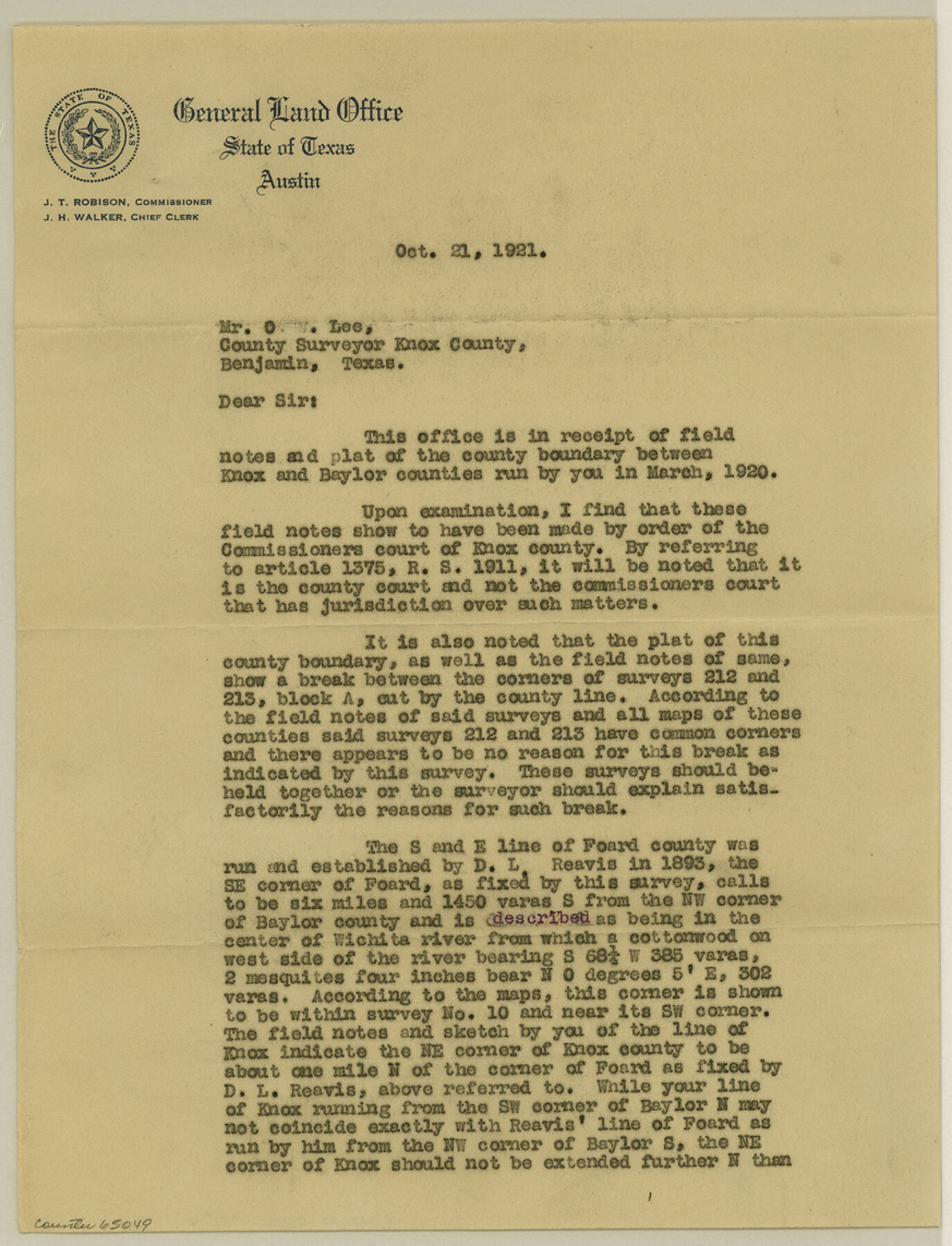
Knox County Boundary File 6
[Letter regarding Knox-Baylor Boundary line]
-
Map/Doc
65049
-
Collection
General Map Collection
-
Counties
Knox
-
Subjects
County Boundaries
-
Height x Width
11.4 x 8.7 inches
29.0 x 22.1 cm
Part of: General Map Collection
Atascosa County Sketch File 4

Print $7.00
- Digital $50.00
Atascosa County Sketch File 4
1854
Size 8.1 x 6.5 inches
Map/Doc 13745
Zavala County Rolled Sketch 25

Print $20.00
- Digital $50.00
Zavala County Rolled Sketch 25
1952
Size 38.4 x 43.4 inches
Map/Doc 10176
Map of Galveston, Turtle & East Bays & portion of the Gulf of Mexico in Chambers & Galveston Counties, Texas showing subdivision therof for mineral development

Print $20.00
- Digital $50.00
Map of Galveston, Turtle & East Bays & portion of the Gulf of Mexico in Chambers & Galveston Counties, Texas showing subdivision therof for mineral development
1935
Size 40.7 x 47.7 inches
Map/Doc 2939
Madison County Working Sketch 9

Print $20.00
- Digital $50.00
Madison County Working Sketch 9
1982
Size 15.7 x 21.1 inches
Map/Doc 70771
Chambers County Sketch File 18b

Print $15.00
- Digital $50.00
Chambers County Sketch File 18b
1901
Size 9.2 x 8.1 inches
Map/Doc 17571
Erath County Working Sketch 38

Print $20.00
- Digital $50.00
Erath County Working Sketch 38
1974
Size 22.1 x 31.7 inches
Map/Doc 69119
Medina County Rolled Sketch 12

Print $20.00
- Digital $50.00
Medina County Rolled Sketch 12
1979
Size 20.9 x 14.7 inches
Map/Doc 6746
Knox County Rolled Sketch 20

Print $20.00
- Digital $50.00
Knox County Rolled Sketch 20
Size 31.5 x 23.3 inches
Map/Doc 6560
Roberts County

Print $20.00
- Digital $50.00
Roberts County
1878
Size 20.1 x 18.0 inches
Map/Doc 3991
Blanco County Working Sketch 6

Print $20.00
- Digital $50.00
Blanco County Working Sketch 6
1923
Size 17.6 x 12.5 inches
Map/Doc 67365
Cochran County Rolled Sketch 2

Print $20.00
- Digital $50.00
Cochran County Rolled Sketch 2
1940
Size 27.7 x 33.9 inches
Map/Doc 5500
Fayette County Sketch File 4

Print $4.00
- Digital $50.00
Fayette County Sketch File 4
Size 11.7 x 7.9 inches
Map/Doc 22504
You may also like
Dallas County Working Sketch 17

Print $40.00
- Digital $50.00
Dallas County Working Sketch 17
Size 23.3 x 50.5 inches
Map/Doc 68583
Brewster County Working Sketch 7

Print $20.00
- Digital $50.00
Brewster County Working Sketch 7
1909
Size 39.9 x 17.1 inches
Map/Doc 67540
Flight Mission No. CRK-3P, Frame 127, Refugio County

Print $20.00
- Digital $50.00
Flight Mission No. CRK-3P, Frame 127, Refugio County
1956
Size 18.6 x 22.3 inches
Map/Doc 86915
[Wilson Strickland Survey]
![91285, [Wilson Strickland Survey], Twichell Survey Records](https://historictexasmaps.com/wmedia_w700/maps/91285-1.tif.jpg)
Print $20.00
- Digital $50.00
[Wilson Strickland Survey]
Size 12.7 x 19.2 inches
Map/Doc 91285
Pecos County Rolled Sketch 143

Print $74.00
- Digital $50.00
Pecos County Rolled Sketch 143
1935
Size 14.8 x 9.4 inches
Map/Doc 48359
Johnson County Sketch File 22

Print $20.00
- Digital $50.00
Johnson County Sketch File 22
1873
Size 18.8 x 16.2 inches
Map/Doc 11891
Archer County Sketch File 15

Print $40.00
- Digital $50.00
Archer County Sketch File 15
1886
Size 16.6 x 17.9 inches
Map/Doc 10827
Dawson County Sketch File 23

Print $4.00
- Digital $50.00
Dawson County Sketch File 23
Size 9.2 x 11.5 inches
Map/Doc 20575
Harris County Rolled Sketch WD

Print $40.00
- Digital $50.00
Harris County Rolled Sketch WD
1936
Size 43.1 x 66.7 inches
Map/Doc 9125
The Republic County of Jackson. September 17, 1838

Print $20.00
The Republic County of Jackson. September 17, 1838
2020
Size 15.6 x 21.8 inches
Map/Doc 96185
Jefferson County Sketch File 34

Print $9.00
- Digital $50.00
Jefferson County Sketch File 34
1900
Size 10.9 x 7.1 inches
Map/Doc 28203
Reagan County Working Sketch 47

Print $20.00
- Digital $50.00
Reagan County Working Sketch 47
1987
Size 23.9 x 43.8 inches
Map/Doc 71890