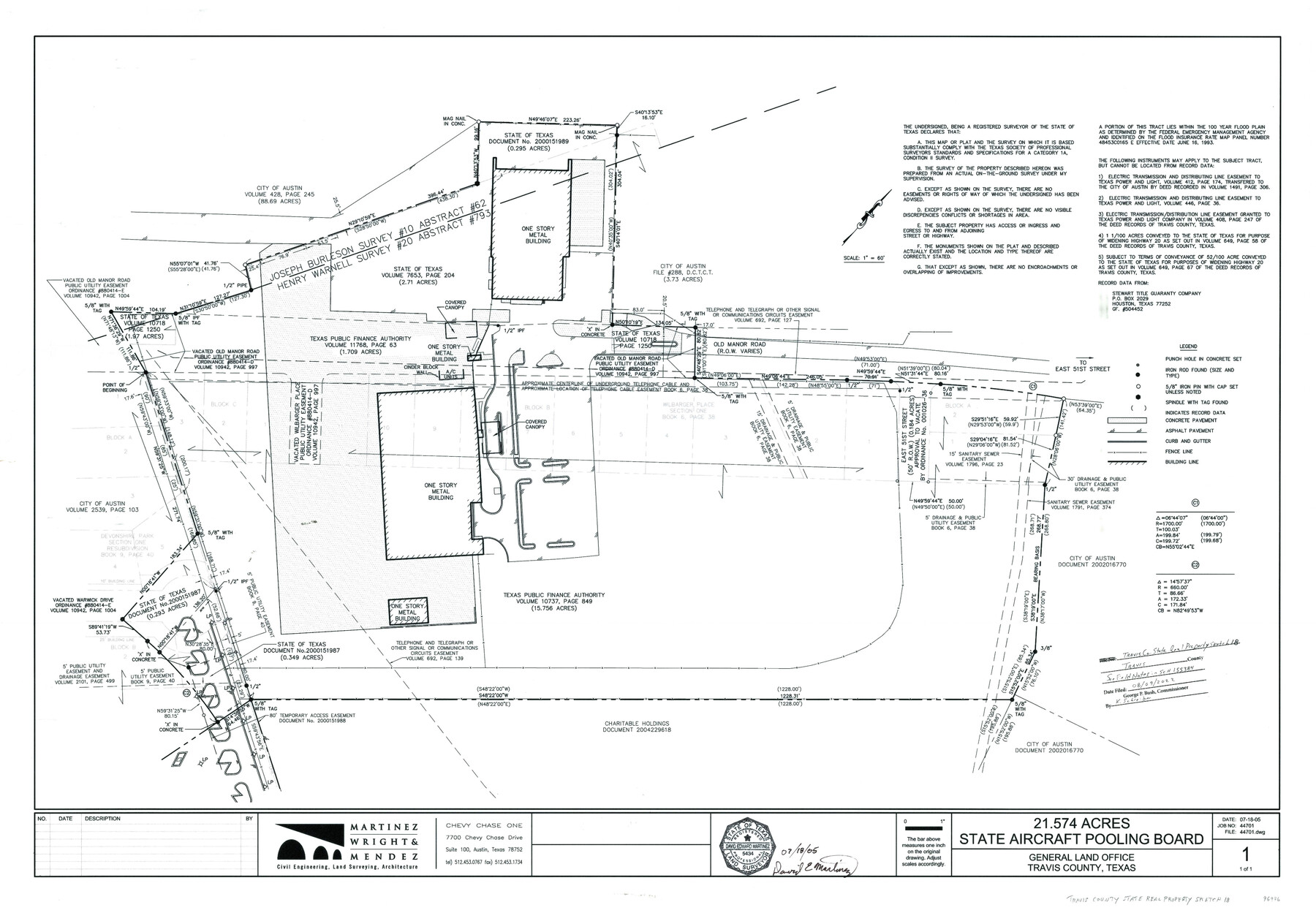
Travis County State Real Property Sketch 18
21.574 acres, State Aircraft Pooling Board
-
Map/Doc
96976
-
Collection
General Map Collection
-
Object Dates
7/18/2005 (Creation Date)
8/9/2022 (File Date)
-
People and Organizations
David E. Martinez (Surveyor/Engineer)
-
Counties
Travis
-
Subjects
State Real Property
-
Height x Width
24.4 x 35.2 inches
62.0 x 89.4 cm
-
Medium
mylar, print
-
Scale
1" = 60 feet
Part of: General Map Collection
Nueces County Sketch File 13a

Print $12.00
- Digital $50.00
Nueces County Sketch File 13a
1889
Size 13.8 x 9.0 inches
Map/Doc 32539
Brewster County Rolled Sketch 100

Print $133.00
- Digital $50.00
Brewster County Rolled Sketch 100
1893
Size 10.1 x 15.4 inches
Map/Doc 43055
Gray County Working Sketch 2

Print $20.00
- Digital $50.00
Gray County Working Sketch 2
1957
Size 26.7 x 27.8 inches
Map/Doc 63233
Cameron County Rolled Sketch 20B

Print $20.00
- Digital $50.00
Cameron County Rolled Sketch 20B
1960
Size 25.2 x 13.5 inches
Map/Doc 5472
Flight Mission No. DAG-22K, Frame 87, Matagorda County

Print $20.00
- Digital $50.00
Flight Mission No. DAG-22K, Frame 87, Matagorda County
1953
Size 18.6 x 22.4 inches
Map/Doc 86471
Culberson County Sketch File WJ2

Print $20.00
- Digital $50.00
Culberson County Sketch File WJ2
Size 15.5 x 20.3 inches
Map/Doc 5788
Intracoastal Waterway in Texas - Corpus Christi to Point Isabel including Arroyo Colorado to Mo. Pac. R.R. Bridge Near Harlingen

Print $20.00
- Digital $50.00
Intracoastal Waterway in Texas - Corpus Christi to Point Isabel including Arroyo Colorado to Mo. Pac. R.R. Bridge Near Harlingen
1934
Size 21.8 x 32.7 inches
Map/Doc 61885
Orange County Sketch File 8

Print $6.00
- Digital $50.00
Orange County Sketch File 8
Size 11.0 x 16.1 inches
Map/Doc 33311
Nueces County Rolled Sketch 125

Print $34.00
Nueces County Rolled Sketch 125
1998
Size 18.1 x 25.0 inches
Map/Doc 7160
Tarrant County Sketch File 29

Print $4.00
- Digital $50.00
Tarrant County Sketch File 29
1879
Size 7.9 x 11.6 inches
Map/Doc 37745
Andrews County Sketch File 4

Print $40.00
- Digital $50.00
Andrews County Sketch File 4
1930
Size 18.5 x 24.2 inches
Map/Doc 10809
Navarro County Sketch File 2

Print $4.00
- Digital $50.00
Navarro County Sketch File 2
1857
Size 9.4 x 8.2 inches
Map/Doc 32298
You may also like
Hale County Rolled Sketch 3

Print $40.00
- Digital $50.00
Hale County Rolled Sketch 3
1891
Size 51.7 x 24.1 inches
Map/Doc 9093
Bee County Sketch File 27

Print $8.00
- Digital $50.00
Bee County Sketch File 27
1886
Size 14.3 x 8.8 inches
Map/Doc 14331
Section N Tech Memorial Park, Inc.

Print $20.00
- Digital $50.00
Section N Tech Memorial Park, Inc.
1950
Size 16.6 x 18.8 inches
Map/Doc 92307
Chambers County Sketch File 25

Print $8.00
- Digital $50.00
Chambers County Sketch File 25
Size 14.1 x 8.7 inches
Map/Doc 17602
[Sections 5 through 34]
![92480, [Sections 5 through 34], Twichell Survey Records](https://historictexasmaps.com/wmedia_w700/maps/92480-1.tif.jpg)
Print $20.00
- Digital $50.00
[Sections 5 through 34]
Size 23.9 x 19.4 inches
Map/Doc 92480
Flight Mission No. BQR-9K, Frame 15, Brazoria County

Print $20.00
- Digital $50.00
Flight Mission No. BQR-9K, Frame 15, Brazoria County
1952
Size 18.8 x 22.5 inches
Map/Doc 84044
Flight Mission No. DCL-6C, Frame 28, Kenedy County

Print $20.00
- Digital $50.00
Flight Mission No. DCL-6C, Frame 28, Kenedy County
1943
Size 18.7 x 22.4 inches
Map/Doc 85885
Travis County Appraisal District Plat Map 2_2915

Print $20.00
- Digital $50.00
Travis County Appraisal District Plat Map 2_2915
Size 21.5 x 26.4 inches
Map/Doc 94219
Plan of the City of Galveston, Texas

Print $20.00
- Digital $50.00
Plan of the City of Galveston, Texas
1845
Size 18.3 x 27.4 inches
Map/Doc 62968
Index for Texas Railroad ROW & track maps available on microfilm at THD & Archives and Records

Print $2.00
- Digital $50.00
Index for Texas Railroad ROW & track maps available on microfilm at THD & Archives and Records
1977
Size 11.2 x 8.8 inches
Map/Doc 60757
Polk County Rolled Sketch 32

Print $20.00
- Digital $50.00
Polk County Rolled Sketch 32
Size 21.6 x 15.8 inches
Map/Doc 7318
Ward County Working Sketch 44

Print $40.00
- Digital $50.00
Ward County Working Sketch 44
1973
Size 50.8 x 34.6 inches
Map/Doc 72350