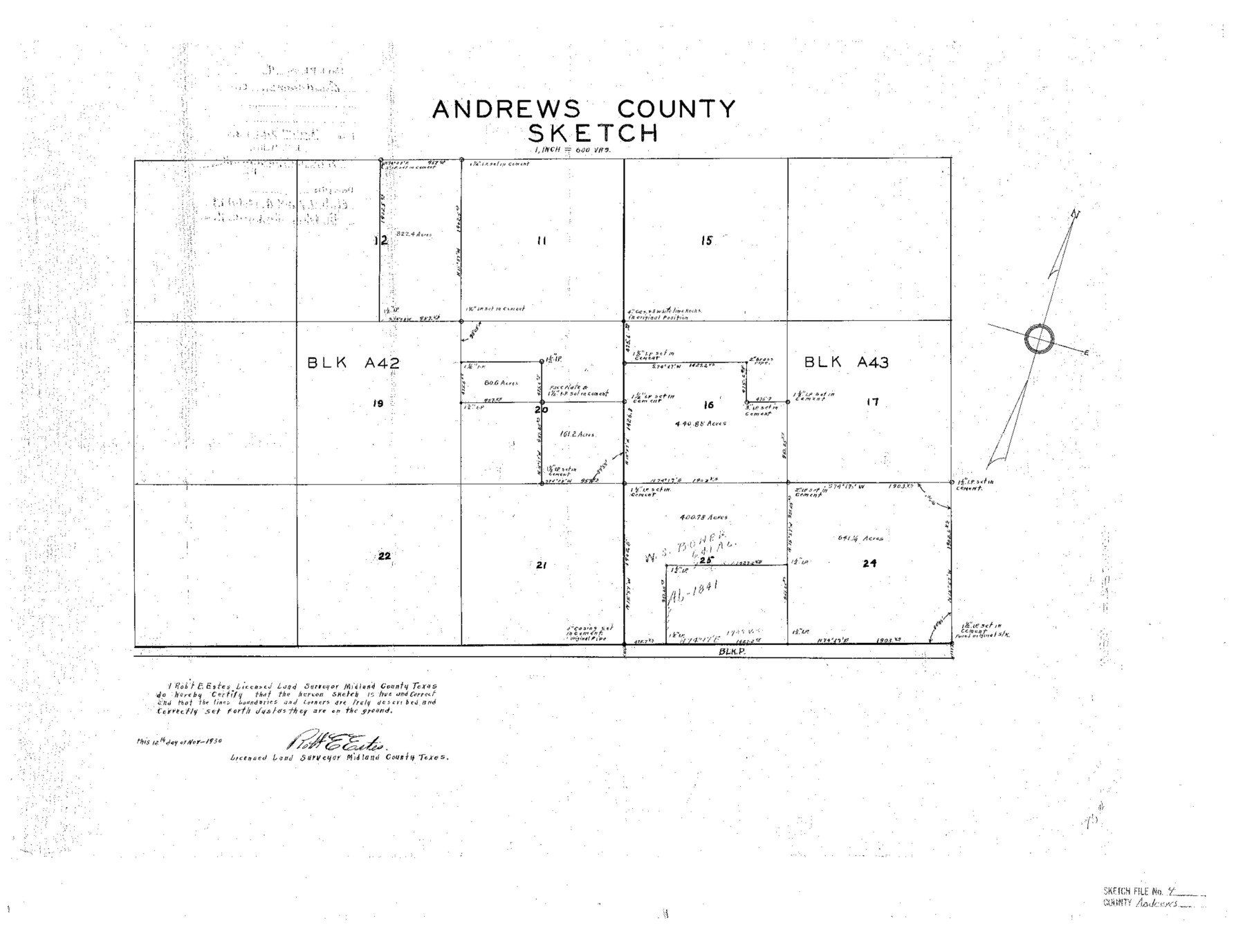
Andrews County Sketch File 4
Andrews County Sketch [showing parts of Blocks A-42 and A-43]
-
Map/Doc
10809
-
Collection
General Map Collection
-
Object Dates
1930/11/12 (Creation Date)
1930/11/22 (File Date)
-
People and Organizations
Robt. E. Estes (Surveyor/Engineer)
-
Counties
Andrews
-
Subjects
Surveying Sketch File
-
Height x Width
18.5 x 24.2 inches
47.0 x 61.5 cm
-
Medium
linen, manuscript
-
Scale
1" = 600 varas
Part of: General Map Collection
Real County Working Sketch 58

Print $20.00
- Digital $50.00
Real County Working Sketch 58
1962
Size 24.7 x 28.5 inches
Map/Doc 71950
Presidio County Sketch File 44

Print $15.00
- Digital $50.00
Presidio County Sketch File 44
1913
Size 11.1 x 9.5 inches
Map/Doc 34525
Runnels County Rolled Sketch B

Print $20.00
- Digital $50.00
Runnels County Rolled Sketch B
1891
Size 17.4 x 19.3 inches
Map/Doc 7540
Controlled Mosaic by Jack Amman Photogrammetric Engineers, Inc - Sheet 6

Print $20.00
- Digital $50.00
Controlled Mosaic by Jack Amman Photogrammetric Engineers, Inc - Sheet 6
1954
Size 20.0 x 24.0 inches
Map/Doc 83450
Map of Comal County

Print $20.00
- Digital $50.00
Map of Comal County
1879
Size 19.3 x 25.7 inches
Map/Doc 4521
Harris County NRC Article 33.136 Sketch 2

Print $30.00
- Digital $50.00
Harris County NRC Article 33.136 Sketch 2
2000
Size 30.6 x 42.2 inches
Map/Doc 61596
San Jacinto County Rolled Sketch 15

Print $20.00
- Digital $50.00
San Jacinto County Rolled Sketch 15
2001
Size 19.2 x 25.2 inches
Map/Doc 7571
Edwards County Working Sketch 115

Print $20.00
- Digital $50.00
Edwards County Working Sketch 115
1973
Size 39.6 x 43.9 inches
Map/Doc 68991
Flight Mission No. BQR-13K, Frame 122, Brazoria County

Print $20.00
- Digital $50.00
Flight Mission No. BQR-13K, Frame 122, Brazoria County
1952
Size 18.6 x 22.3 inches
Map/Doc 84083
Travis County Working Sketch 63

Print $20.00
- Digital $50.00
Travis County Working Sketch 63
1998
Size 24.0 x 29.5 inches
Map/Doc 69447
Hays County Rolled Sketch 26

Print $20.00
- Digital $50.00
Hays County Rolled Sketch 26
1943
Size 27.7 x 25.6 inches
Map/Doc 6182
McCulloch County Boundary File 64

Print $36.00
- Digital $50.00
McCulloch County Boundary File 64
Size 9.2 x 8.9 inches
Map/Doc 56919
You may also like
Waller County, Texas

Print $20.00
- Digital $50.00
Waller County, Texas
1879
Size 22.8 x 17.7 inches
Map/Doc 764
Leon County Sketch File 28

Print $8.00
- Digital $50.00
Leon County Sketch File 28
1951
Size 11.2 x 8.7 inches
Map/Doc 29821
Flight Mission No. DQO-1K, Frame 151, Galveston County

Print $20.00
- Digital $50.00
Flight Mission No. DQO-1K, Frame 151, Galveston County
1952
Size 18.8 x 22.5 inches
Map/Doc 85004
Cameron County Rolled Sketch Z

Print $20.00
- Digital $50.00
Cameron County Rolled Sketch Z
1936
Size 24.6 x 31.3 inches
Map/Doc 5400
Atascosa County Working Sketch 2

Print $20.00
- Digital $50.00
Atascosa County Working Sketch 2
1910
Size 23.5 x 33.2 inches
Map/Doc 67197
Sectional map of Texas traversed by the Missouri, Kansas & Texas Railway, showing the crops adapted to each section, with the elevation and annual rainfall

Print $20.00
- Digital $50.00
Sectional map of Texas traversed by the Missouri, Kansas & Texas Railway, showing the crops adapted to each section, with the elevation and annual rainfall
1904
Size 21.9 x 23.0 inches
Map/Doc 95815
Dimmit County Working Sketch 46
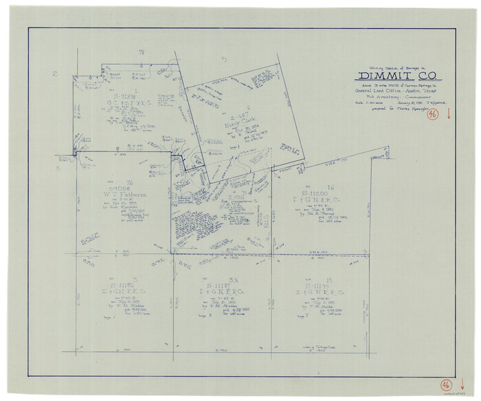
Print $20.00
- Digital $50.00
Dimmit County Working Sketch 46
1980
Size 25.7 x 31.0 inches
Map/Doc 68707
Wharton County

Print $40.00
- Digital $50.00
Wharton County
1946
Size 43.0 x 49.2 inches
Map/Doc 73321
Flight Mission No. DAH-9M, Frame 157, Orange County

Print $20.00
- Digital $50.00
Flight Mission No. DAH-9M, Frame 157, Orange County
1953
Size 18.5 x 22.5 inches
Map/Doc 86856
Bandera County Working Sketch 16c

Print $20.00
- Digital $50.00
Bandera County Working Sketch 16c
1942
Size 18.2 x 22.0 inches
Map/Doc 67611
[Northwest part of County showing surveys along Spring Creek, Harvey Creek, and Red Hollow Creek]
![90909, [Northwest part of County showing surveys along Spring Creek, Harvey Creek, and Red Hollow Creek], Twichell Survey Records](https://historictexasmaps.com/wmedia_w700/maps/90909-1.tif.jpg)
Print $20.00
- Digital $50.00
[Northwest part of County showing surveys along Spring Creek, Harvey Creek, and Red Hollow Creek]
Size 18.5 x 14.4 inches
Map/Doc 90909
Potter County Rolled Sketch 3

Print $20.00
- Digital $50.00
Potter County Rolled Sketch 3
1892
Map/Doc 9758