![90909, [Northwest part of County showing surveys along Spring Creek, Harvey Creek, and Red Hollow Creek], Twichell Survey Records](https://historictexasmaps.com/wmedia_w1800h1800/maps/90909-1.tif.jpg)
[Northwest part of County showing surveys along Spring Creek, Harvey Creek, and Red Hollow Creek]
85-42
-
Map/Doc
90909
-
Collection
Twichell Survey Records
-
Counties
Garza Crosby
-
Height x Width
18.5 x 14.4 inches
47.0 x 36.6 cm
Part of: Twichell Survey Records
[PSL Block B-19]
![93127, [PSL Block B-19], Twichell Survey Records](https://historictexasmaps.com/wmedia_w700/maps/93127-1.tif.jpg)
Print $40.00
- Digital $50.00
[PSL Block B-19]
Size 49.1 x 45.5 inches
Map/Doc 93127
Map of Rotan Fisher County, Texas

Print $20.00
- Digital $50.00
Map of Rotan Fisher County, Texas
1926
Size 32.2 x 36.5 inches
Map/Doc 93231
Olton Independent School District Lamb County, Texas

Print $20.00
- Digital $50.00
Olton Independent School District Lamb County, Texas
Size 22.3 x 28.5 inches
Map/Doc 92202
Map of Glasscock County

Print $20.00
- Digital $50.00
Map of Glasscock County
Size 18.9 x 23.2 inches
Map/Doc 90711
Oldham County

Print $20.00
- Digital $50.00
Oldham County
1888
Size 19.6 x 16.5 inches
Map/Doc 93018
[Sketch of part of Blks. B5, 6, 2Z, M6, M8, M11 and M15]
![89644, [Sketch of part of Blks. B5, 6, 2Z, M6, M8, M11 and M15], Twichell Survey Records](https://historictexasmaps.com/wmedia_w700/maps/89644-1.tif.jpg)
Print $40.00
- Digital $50.00
[Sketch of part of Blks. B5, 6, 2Z, M6, M8, M11 and M15]
Size 18.6 x 62.0 inches
Map/Doc 89644
Part of Garza, Crosby, Lynn, and Lubbock Counties

Print $20.00
- Digital $50.00
Part of Garza, Crosby, Lynn, and Lubbock Counties
1912
Size 24.7 x 20.4 inches
Map/Doc 91324
Amarillo Improvements for Sawville-Amarillo Heights

Print $40.00
- Digital $50.00
Amarillo Improvements for Sawville-Amarillo Heights
Size 37.2 x 62.1 inches
Map/Doc 89789
[H. & G. N. Block 1]
![90946, [H. & G. N. Block 1], Twichell Survey Records](https://historictexasmaps.com/wmedia_w700/maps/90946-1.tif.jpg)
Print $20.00
- Digital $50.00
[H. & G. N. Block 1]
1873
Size 17.7 x 14.5 inches
Map/Doc 90946
[Sections 302-313 and sections south of Blocks D and AX]
![92017, [Sections 302-313 and sections south of Blocks D and AX], Twichell Survey Records](https://historictexasmaps.com/wmedia_w700/maps/92017-1.tif.jpg)
Print $20.00
- Digital $50.00
[Sections 302-313 and sections south of Blocks D and AX]
Size 17.5 x 35.6 inches
Map/Doc 92017
[Block 1, Section 31]
![92171, [Block 1, Section 31], Twichell Survey Records](https://historictexasmaps.com/wmedia_w700/maps/92171-1.tif.jpg)
Print $20.00
- Digital $50.00
[Block 1, Section 31]
1946
Size 24.3 x 19.7 inches
Map/Doc 92171
Ed. F. Mann's Subdivision of Stephens County School Land, Crosby County, Texas

Print $20.00
- Digital $50.00
Ed. F. Mann's Subdivision of Stephens County School Land, Crosby County, Texas
Size 19.2 x 22.3 inches
Map/Doc 90356
You may also like
Presidio County Working Sketch 106

Print $40.00
- Digital $50.00
Presidio County Working Sketch 106
1980
Size 25.4 x 74.7 inches
Map/Doc 71783
Ellis County Sketch File 12

Print $60.00
- Digital $50.00
Ellis County Sketch File 12
1860
Size 12.9 x 16.1 inches
Map/Doc 21849
McMullen County Boundary File 7

Print $5.00
- Digital $50.00
McMullen County Boundary File 7
Size 7.2 x 17.0 inches
Map/Doc 57017
Wilbarger County Aerial Photograph Index Sheet 1

Print $20.00
- Digital $50.00
Wilbarger County Aerial Photograph Index Sheet 1
1950
Size 22.4 x 18.9 inches
Map/Doc 83750
Brewster County Rolled Sketch 22F

Print $20.00
- Digital $50.00
Brewster County Rolled Sketch 22F
1909
Size 19.0 x 25.4 inches
Map/Doc 5206
[Public School Land Blocks]
![93152, [Public School Land Blocks], Twichell Survey Records](https://historictexasmaps.com/wmedia_w700/maps/93152-1.tif.jpg)
Print $40.00
- Digital $50.00
[Public School Land Blocks]
Size 41.3 x 113.1 inches
Map/Doc 93152
Armstrong County Sketch File 3

Print $40.00
- Digital $50.00
Armstrong County Sketch File 3
1883
Size 27.4 x 29.4 inches
Map/Doc 10839
Sterling County Rolled Sketch 20

Print $20.00
- Digital $50.00
Sterling County Rolled Sketch 20
Size 30.5 x 34.5 inches
Map/Doc 9952
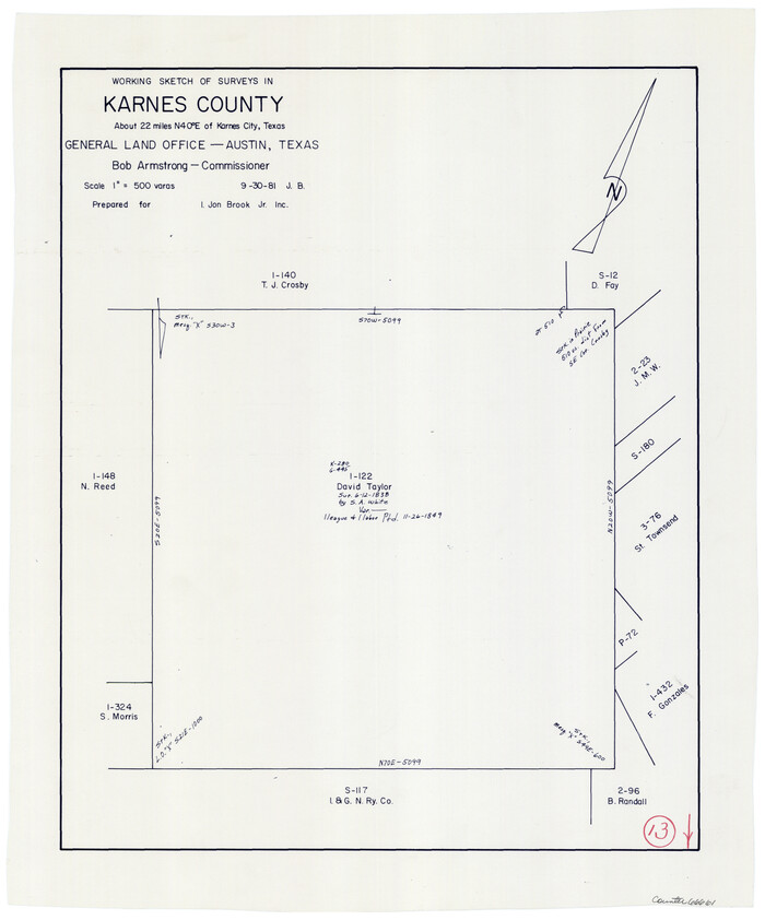
Karnes County Working Sketch 13
Print $20.00
- Digital $50.00
Karnes County Working Sketch 13
1981
Size 20.2 x 16.8 inches
Map/Doc 66661


Coleman County Sketch File 44

Print $17.00
- Digital $50.00
Coleman County Sketch File 44
Size 14.1 x 8.6 inches
Map/Doc 18783