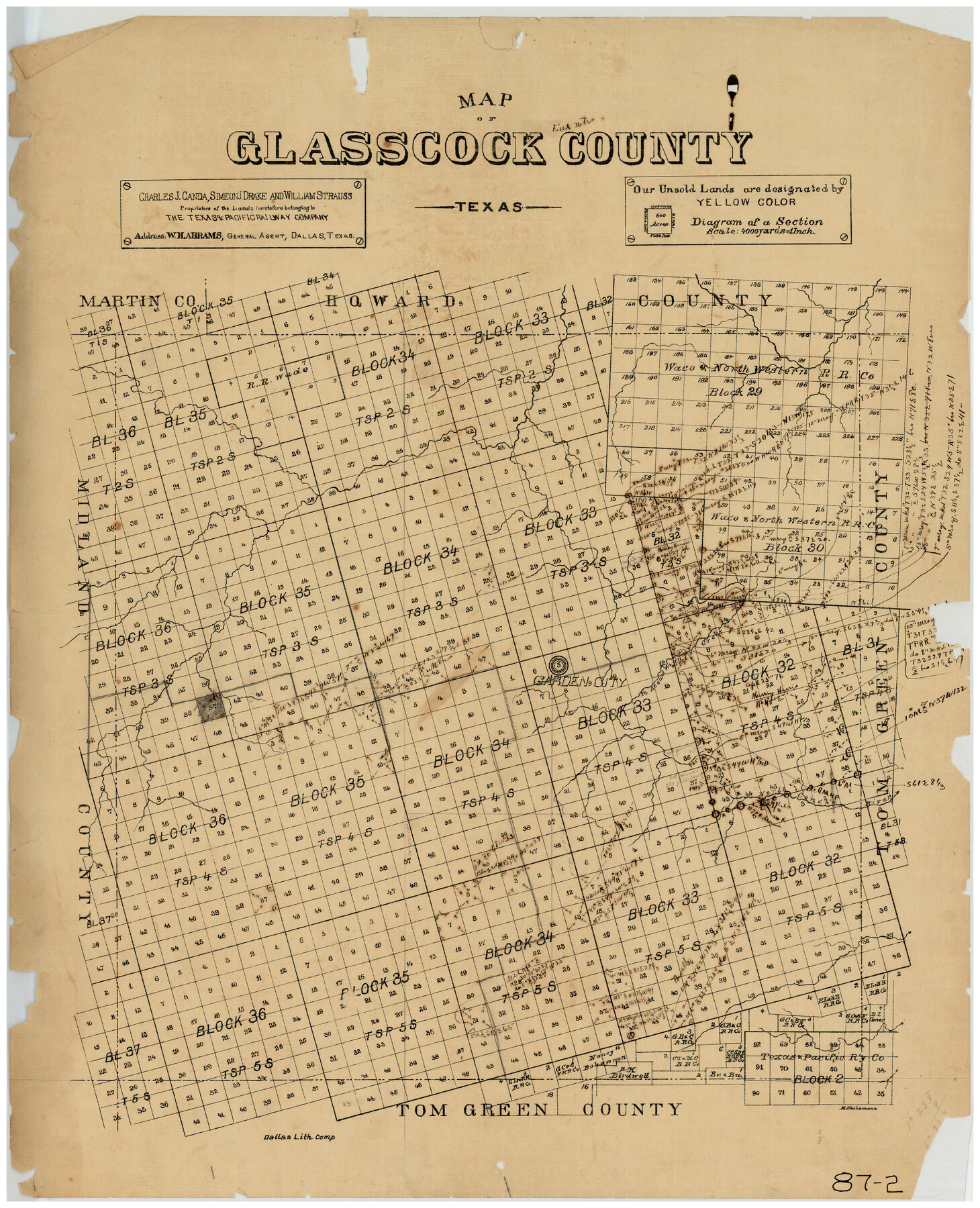
Map of Glasscock County
87-2
-
Map/Doc
90711
-
Collection
Twichell Survey Records
-
Counties
Glasscock
-
Subjects
County
-
Height x Width
18.9 x 23.2 inches
48.0 x 58.9 cm
Part of: Twichell Survey Records
[Sections 58-64, I. & G. N. Block 1]
![91546, [Sections 58-64, I. & G. N. Block 1], Twichell Survey Records](https://historictexasmaps.com/wmedia_w700/maps/91546-1.tif.jpg)
Print $2.00
- Digital $50.00
[Sections 58-64, I. & G. N. Block 1]
Size 8.6 x 11.1 inches
Map/Doc 91546
Sketch in Block 9, Potter County Texas

Print $20.00
- Digital $50.00
Sketch in Block 9, Potter County Texas
1945
Size 15.7 x 18.5 inches
Map/Doc 91719
Sketch Showing Lands Conveyed to Texas State Park Board by the City of Lubbock, Texas for the Location of MacKenzie State Park

Print $20.00
- Digital $50.00
Sketch Showing Lands Conveyed to Texas State Park Board by the City of Lubbock, Texas for the Location of MacKenzie State Park
1935
Size 26.4 x 33.1 inches
Map/Doc 92724
[Blocks M-23, M-17, M-18, H, G, and vicinity]
![91141, [Blocks M-23, M-17, M-18, H, G, and vicinity], Twichell Survey Records](https://historictexasmaps.com/wmedia_w700/maps/91141-1.tif.jpg)
Print $20.00
- Digital $50.00
[Blocks M-23, M-17, M-18, H, G, and vicinity]
1882
Size 12.9 x 12.4 inches
Map/Doc 91141
[H. & T. C. RR. Co. Block 48 and vicinity]
![90647, [H. & T. C. RR. Co. Block 48 and vicinity], Twichell Survey Records](https://historictexasmaps.com/wmedia_w700/maps/90647-1.tif.jpg)
Print $20.00
- Digital $50.00
[H. & T. C. RR. Co. Block 48 and vicinity]
Size 35.4 x 24.4 inches
Map/Doc 90647
[Township 5-S, Blocks 36, 37 & 38]
![92292, [Township 5-S, Blocks 36, 37 & 38], Twichell Survey Records](https://historictexasmaps.com/wmedia_w700/maps/92292-1.tif.jpg)
Print $20.00
- Digital $50.00
[Township 5-S, Blocks 36, 37 & 38]
1952
Size 27.7 x 26.6 inches
Map/Doc 92292
[Blocks M13, S1, C3, JK3, and JK]
![90701, [Blocks M13, S1, C3, JK3, and JK], Twichell Survey Records](https://historictexasmaps.com/wmedia_w700/maps/90701-1.tif.jpg)
Print $20.00
- Digital $50.00
[Blocks M13, S1, C3, JK3, and JK]
Size 26.6 x 15.3 inches
Map/Doc 90701
Dawson County Sketch showing survey made in accordance with an order of the Hon. District Court of Garza County July Term A.D. 1917 in the case of F. M. Weaver vs. A. W. Higginbotham #41

Print $20.00
- Digital $50.00
Dawson County Sketch showing survey made in accordance with an order of the Hon. District Court of Garza County July Term A.D. 1917 in the case of F. M. Weaver vs. A. W. Higginbotham #41
1917
Size 23.1 x 18.1 inches
Map/Doc 90637
[Blocks DT, P, CK, C2, and D7]
![91307, [Blocks DT, P, CK, C2, and D7], Twichell Survey Records](https://historictexasmaps.com/wmedia_w700/maps/91307-1.tif.jpg)
Print $20.00
- Digital $50.00
[Blocks DT, P, CK, C2, and D7]
Size 23.6 x 9.6 inches
Map/Doc 91307
Sketch Terrell and Val Verde Counties

Print $20.00
- Digital $50.00
Sketch Terrell and Val Verde Counties
1932
Size 41.9 x 18.3 inches
Map/Doc 91947
Sketch Z [Blocks K6 and K11]
![90610, Sketch Z [Blocks K6 and K11], Twichell Survey Records](https://historictexasmaps.com/wmedia_w700/maps/90610-1.tif.jpg)
Print $20.00
- Digital $50.00
Sketch Z [Blocks K6 and K11]
1903
Size 28.2 x 27.0 inches
Map/Doc 90610
[H. & G. N. Block 28]
![90357, [H. & G. N. Block 28], Twichell Survey Records](https://historictexasmaps.com/wmedia_w700/maps/90357-1.tif.jpg)
Print $20.00
- Digital $50.00
[H. & G. N. Block 28]
1903
Size 21.9 x 28.8 inches
Map/Doc 90357
You may also like
Coke County Rolled Sketch 31

Print $20.00
- Digital $50.00
Coke County Rolled Sketch 31
1982
Size 13.3 x 30.2 inches
Map/Doc 5526
Map of Texas with population and location of principal towns and cities according to latest reliable statistics

Print $20.00
- Digital $50.00
Map of Texas with population and location of principal towns and cities according to latest reliable statistics
1908
Size 18.5 x 20.4 inches
Map/Doc 95873
Jeff Davis County Rolled Sketch 19

Print $40.00
- Digital $50.00
Jeff Davis County Rolled Sketch 19
1885
Size 37.1 x 57.9 inches
Map/Doc 9265
English Field Notes of the Spanish Archives - Books TJG, DB, A, A2, B, B2, WB, and WR

English Field Notes of the Spanish Archives - Books TJG, DB, A, A2, B, B2, WB, and WR
1835
Map/Doc 96553
[Sketch showing Blocks B5, B6 and G.&M. Block 5 north of Capitol Land]
![92990, [Sketch showing Blocks B5, B6 and G.&M. Block 5 north of Capitol Land], Twichell Survey Records](https://historictexasmaps.com/wmedia_w700/maps/92990-1.tif.jpg)
Print $20.00
- Digital $50.00
[Sketch showing Blocks B5, B6 and G.&M. Block 5 north of Capitol Land]
Size 20.7 x 38.2 inches
Map/Doc 92990
Parker County Working Sketch 11

Print $20.00
- Digital $50.00
Parker County Working Sketch 11
1969
Map/Doc 71461
[Leagues 53 through 57]
![92483, [Leagues 53 through 57], Twichell Survey Records](https://historictexasmaps.com/wmedia_w700/maps/92483-1.tif.jpg)
Print $20.00
- Digital $50.00
[Leagues 53 through 57]
1913
Size 17.8 x 19.0 inches
Map/Doc 92483
Hardeman County

Print $20.00
- Digital $50.00
Hardeman County
1935
Size 42.8 x 40.0 inches
Map/Doc 77302

Victoria County Sketch File 10

Print $4.00
- Digital $50.00
Victoria County Sketch File 10
1873
Size 10.1 x 8.4 inches
Map/Doc 39534
Office sketch of surveys on St. Joseph Island and Mustang Island in Aransas & Nueces Cos.

Print $20.00
- Digital $50.00
Office sketch of surveys on St. Joseph Island and Mustang Island in Aransas & Nueces Cos.
1978
Size 42.8 x 17.7 inches
Map/Doc 2252
Sterling County Rolled Sketch 38

Print $20.00
- Digital $50.00
Sterling County Rolled Sketch 38
1988
Size 25.0 x 31.7 inches
Map/Doc 7863