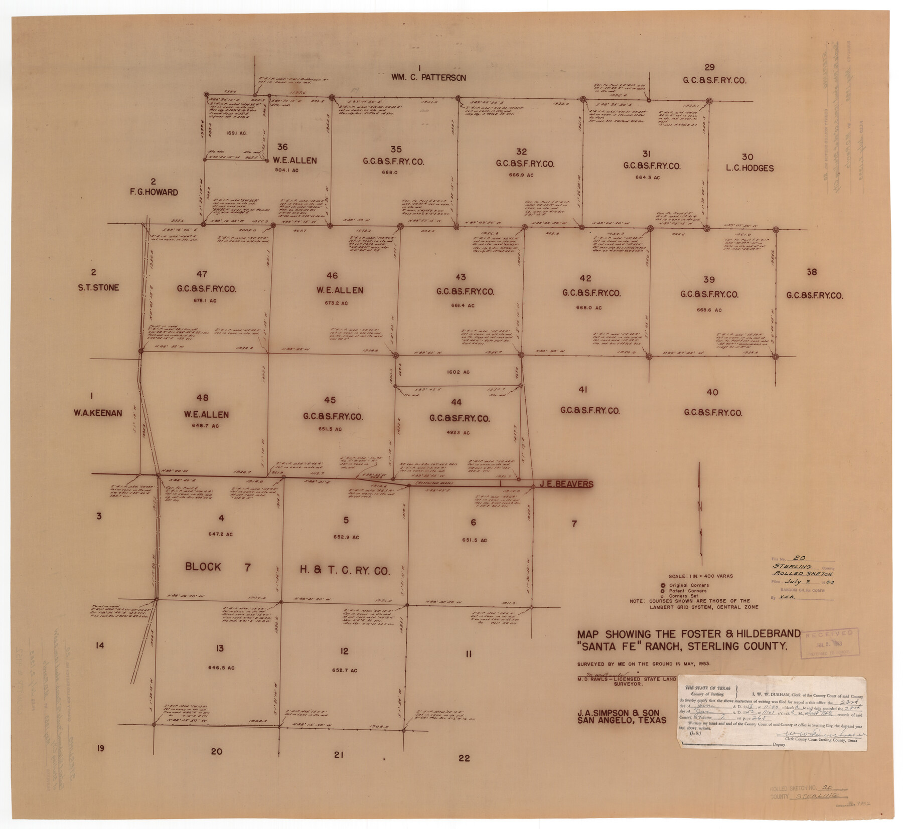
Sterling County Rolled Sketch 20
Map showing the Foster & Hildebrand "Santa Fe" Ranch, Sterling County
-
Map/Doc
9952
-
Collection
General Map Collection
-
Object Dates
7/2/1953 (File Date)
5/1953 (Survey Date)
-
People and Organizations
M.D. Rawls (Surveyor/Engineer)
-
Counties
Sterling
-
Subjects
Surveying Rolled Sketch
-
Height x Width
30.5 x 34.5 inches
77.5 x 87.6 cm
-
Medium
van dyke/brownline/sepia
-
Scale
1" = 400 varas
Part of: General Map Collection
Flight Mission No. CUG-1P, Frame 25, Kleberg County

Print $20.00
- Digital $50.00
Flight Mission No. CUG-1P, Frame 25, Kleberg County
1956
Size 18.6 x 22.3 inches
Map/Doc 86115
Jefferson County Working Sketch 37

Print $40.00
- Digital $50.00
Jefferson County Working Sketch 37
1982
Size 49.9 x 36.6 inches
Map/Doc 66581
Flight Mission No. CGI-1N, Frame 182, Cameron County

Print $20.00
- Digital $50.00
Flight Mission No. CGI-1N, Frame 182, Cameron County
1955
Size 18.6 x 22.3 inches
Map/Doc 84517
El Paso County Working Sketch 17

Print $20.00
- Digital $50.00
El Paso County Working Sketch 17
1958
Size 28.4 x 26.3 inches
Map/Doc 69039
Brazoria County Working Sketch 19

Print $40.00
- Digital $50.00
Brazoria County Working Sketch 19
1951
Size 50.3 x 42.3 inches
Map/Doc 67504
Williamson County Working Sketch 20

Print $20.00
- Digital $50.00
Williamson County Working Sketch 20
1995
Size 23.8 x 40.7 inches
Map/Doc 72580
San Patricio County Rolled Sketch 46F

Print $4.00
- Digital $50.00
San Patricio County Rolled Sketch 46F
1983
Size 18.0 x 23.1 inches
Map/Doc 8377
Bowie County Sketch File 7b

Print $10.00
- Digital $50.00
Bowie County Sketch File 7b
1927
Size 10.7 x 8.6 inches
Map/Doc 14859
Harris County NRC Article 33.136 Sketch 7

Print $20.00
- Digital $50.00
Harris County NRC Article 33.136 Sketch 7
2004
Size 24.3 x 18.5 inches
Map/Doc 82991
Hutchinson County Rolled Sketch 40

Print $20.00
- Digital $50.00
Hutchinson County Rolled Sketch 40
1981
Size 25.7 x 37.4 inches
Map/Doc 6297
Cooke County Boundary File 4

Print $6.00
- Digital $50.00
Cooke County Boundary File 4
Size 8.6 x 11.3 inches
Map/Doc 51855
San Patricio County NRC Article 33.136 Sketch 8

Print $26.00
- Digital $50.00
San Patricio County NRC Article 33.136 Sketch 8
2018
Size 11.0 x 17.0 inches
Map/Doc 95341
You may also like
Pecos County Working Sketch 131

Print $20.00
- Digital $50.00
Pecos County Working Sketch 131
1977
Size 27.8 x 21.1 inches
Map/Doc 71605
Section H Tech Memorial Park, Inc.

Print $20.00
- Digital $50.00
Section H Tech Memorial Park, Inc.
Size 18.0 x 11.3 inches
Map/Doc 92302
Flight Mission No. DAG-21K, Frame 127, Matagorda County

Print $20.00
- Digital $50.00
Flight Mission No. DAG-21K, Frame 127, Matagorda County
1952
Size 18.5 x 22.4 inches
Map/Doc 86453
Montgomery County Sketch File 21

Print $8.00
- Digital $50.00
Montgomery County Sketch File 21
1934
Size 9.0 x 13.2 inches
Map/Doc 31856
W.D. Twichell's and R.S. Hunnicutt's Resurvey in Oldham County, Texas May to October 1915

Print $20.00
- Digital $50.00
W.D. Twichell's and R.S. Hunnicutt's Resurvey in Oldham County, Texas May to October 1915
1915
Size 47.6 x 38.3 inches
Map/Doc 89970
Coleman County Sketch File 29

Print $40.00
- Digital $50.00
Coleman County Sketch File 29
1873
Size 16.9 x 12.9 inches
Map/Doc 18718
McLennan County Sketch File 5

Print $9.00
- Digital $50.00
McLennan County Sketch File 5
Size 11.0 x 17.0 inches
Map/Doc 31240
Map of Presidio County, Texas

Print $40.00
- Digital $50.00
Map of Presidio County, Texas
Size 42.6 x 86.0 inches
Map/Doc 76071
Coast Chart no. 109, Aransas Pass, Aransas and Copano Bays, Texas

Print $20.00
Coast Chart no. 109, Aransas Pass, Aransas and Copano Bays, Texas
1884
Size 44.7 x 36.7 inches
Map/Doc 76227
Flight Mission No. BRA-16M, Frame 120, Jefferson County

Print $20.00
- Digital $50.00
Flight Mission No. BRA-16M, Frame 120, Jefferson County
1953
Size 18.4 x 22.6 inches
Map/Doc 85730
[Surveys near the Neches River]
![8, [Surveys near the Neches River], General Map Collection](https://historictexasmaps.com/wmedia_w700/maps/8.tif.jpg)
Print $3.00
- Digital $50.00
[Surveys near the Neches River]
Size 17.2 x 10.3 inches
Map/Doc 8
Matagorda County Sketch File 3

Print $4.00
- Digital $50.00
Matagorda County Sketch File 3
1876
Size 12.9 x 8.0 inches
Map/Doc 30732