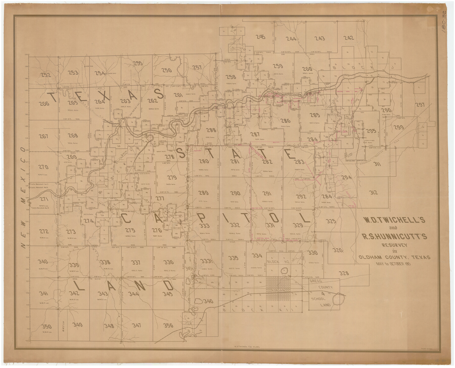
W.D. Twichell's and R.S. Hunnicutt's Resurvey in Oldham County, Texas May to October 1915
180-32
-
Map/Doc
89970
-
Collection
Twichell Survey Records
-
Object Dates
10/1915 (Creation Date)
-
Counties
Oldham
-
Height x Width
47.6 x 38.3 inches
120.9 x 97.3 cm
Part of: Twichell Survey Records
[H. & T. C. Block 47, Sections 58-66 and part of Block 3]
![91791, [H. & T. C. Block 47, Sections 58-66 and part of Block 3], Twichell Survey Records](https://historictexasmaps.com/wmedia_w700/maps/91791-1.tif.jpg)
Print $20.00
- Digital $50.00
[H. & T. C. Block 47, Sections 58-66 and part of Block 3]
Size 24.1 x 12.7 inches
Map/Doc 91791
[H. & G.N. RR. Co. Block 4 and vicinity]
![92160, [H. & G.N. RR. Co. Block 4 and vicinity], Twichell Survey Records](https://historictexasmaps.com/wmedia_w700/maps/92160-1.tif.jpg)
Print $20.00
- Digital $50.00
[H. & G.N. RR. Co. Block 4 and vicinity]
Size 40.8 x 37.4 inches
Map/Doc 92160
[Yates, just south of Runnels County School Land]
![91653, [Yates, just south of Runnels County School Land], Twichell Survey Records](https://historictexasmaps.com/wmedia_w700/maps/91653-1.tif.jpg)
Print $20.00
- Digital $50.00
[Yates, just south of Runnels County School Land]
1928
Size 17.7 x 22.7 inches
Map/Doc 91653
Sketch Showing Survey of Sec. 2 Public School Lands Block B-16, Ector County, Texas

Print $20.00
- Digital $50.00
Sketch Showing Survey of Sec. 2 Public School Lands Block B-16, Ector County, Texas
1930
Size 39.6 x 20.9 inches
Map/Doc 90924
[Map of Panhandle Counties]
![91170, [Map of Panhandle Counties], Twichell Survey Records](https://historictexasmaps.com/wmedia_w700/maps/91170-1.tif.jpg)
Print $20.00
- Digital $50.00
[Map of Panhandle Counties]
Size 27.4 x 22.9 inches
Map/Doc 91170
Working Sketch Hale County

Print $20.00
- Digital $50.00
Working Sketch Hale County
1909
Size 17.9 x 20.9 inches
Map/Doc 90745
[Area around J. E. Arnold survey]
![91885, [Area around J. E. Arnold survey], Twichell Survey Records](https://historictexasmaps.com/wmedia_w700/maps/91885-1.tif.jpg)
Print $2.00
- Digital $50.00
[Area around J. E. Arnold survey]
Size 15.3 x 8.2 inches
Map/Doc 91885
[Sketch Showing South part of Capitol Lands]
![93086, [Sketch Showing South part of Capitol Lands], Twichell Survey Records](https://historictexasmaps.com/wmedia_w700/maps/93086-1.tif.jpg)
Print $20.00
- Digital $50.00
[Sketch Showing South part of Capitol Lands]
Size 47.3 x 17.7 inches
Map/Doc 93086
[Area Surrounding Charles Ragsdale, M. George, and H. Ward Surveys]
![91535, [Area Surrounding Charles Ragsdale, M. George, and H. Ward Surveys], Twichell Survey Records](https://historictexasmaps.com/wmedia_w700/maps/91535-1.tif.jpg)
Print $20.00
- Digital $50.00
[Area Surrounding Charles Ragsdale, M. George, and H. Ward Surveys]
Size 20.0 x 23.3 inches
Map/Doc 91535
J. E. and J. W. Rhea's Ranch situated in Parmer Co., Texas

Print $20.00
- Digital $50.00
J. E. and J. W. Rhea's Ranch situated in Parmer Co., Texas
Size 23.2 x 24.3 inches
Map/Doc 91607
Jeff Davis Co.

Print $20.00
- Digital $50.00
Jeff Davis Co.
1915
Size 26.1 x 28.3 inches
Map/Doc 92175
[Northeast 1/4 County]
![90876, [Northeast 1/4 County], Twichell Survey Records](https://historictexasmaps.com/wmedia_w700/maps/90876-2.tif.jpg)
Print $20.00
- Digital $50.00
[Northeast 1/4 County]
Size 11.9 x 20.3 inches
Map/Doc 90876
You may also like
Maverick County Sketch File 15a

Print $20.00
- Digital $50.00
Maverick County Sketch File 15a
1886
Size 30.8 x 30.3 inches
Map/Doc 10536
Medina County Sketch File 22

Print $38.00
- Digital $50.00
Medina County Sketch File 22
2007
Size 11.0 x 8.5 inches
Map/Doc 93633
[H. & T. C. RR. Company, Block 46, Sections 60- 69]
![91253, [H. & T. C. RR. Company, Block 46, Sections 60- 69], Twichell Survey Records](https://historictexasmaps.com/wmedia_w700/maps/91253-1.tif.jpg)
Print $20.00
- Digital $50.00
[H. & T. C. RR. Company, Block 46, Sections 60- 69]
Size 29.8 x 18.3 inches
Map/Doc 91253
Zavala County

Print $40.00
- Digital $50.00
Zavala County
1915
Size 39.6 x 48.3 inches
Map/Doc 63147
Pecos County Rolled Sketch 78

Print $40.00
- Digital $50.00
Pecos County Rolled Sketch 78
1930
Size 52.6 x 44.1 inches
Map/Doc 9705
Upshur County Sketch File 20

Print $4.00
- Digital $50.00
Upshur County Sketch File 20
1873
Size 5.7 x 8.3 inches
Map/Doc 38792
Nueces County NRC Article 33.136 Sketch 3

Print $68.00
- Digital $50.00
Nueces County NRC Article 33.136 Sketch 3
2002
Size 24.7 x 36.5 inches
Map/Doc 87922
Flight Mission No. DIX-5P, Frame 108, Aransas County

Print $20.00
- Digital $50.00
Flight Mission No. DIX-5P, Frame 108, Aransas County
1956
Size 17.2 x 18.1 inches
Map/Doc 83787
[Leagues 139 and 130]
![90440, [Leagues 139 and 130], Twichell Survey Records](https://historictexasmaps.com/wmedia_w700/maps/90440-1.tif.jpg)
Print $2.00
- Digital $50.00
[Leagues 139 and 130]
Size 7.9 x 12.5 inches
Map/Doc 90440
Angelina County Sketch File 26

Print $40.00
- Digital $50.00
Angelina County Sketch File 26
1909
Size 18.0 x 23.0 inches
Map/Doc 10817
The Republic County of Bowie. January 28, 1841

Print $20.00
The Republic County of Bowie. January 28, 1841
2020
Size 19.5 x 21.7 inches
Map/Doc 96103
Hall County Working Sketch Graphic Index

Print $20.00
- Digital $50.00
Hall County Working Sketch Graphic Index
1972
Size 41.7 x 33.7 inches
Map/Doc 76563