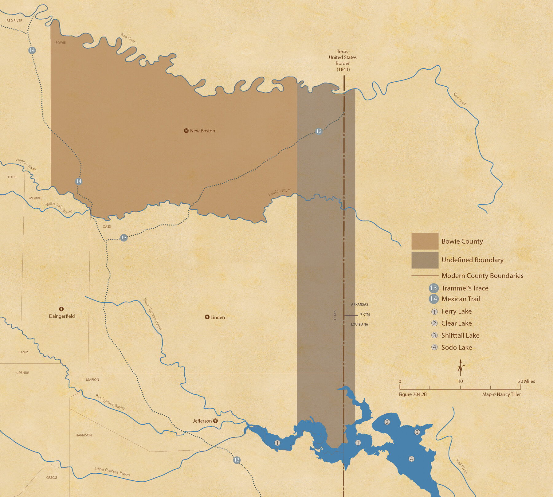
The Republic County of Bowie. January 28, 1841
Figure No. 704.2 from 'A Boundary Atlas of Texas, 1821-1845' by Jim Tiller
-
Map/Doc
96103
-
Collection
Nancy and Jim Tiller Digital Collection
-
Object Dates
2020/1/1 (Creation Date)
-
People and Organizations
Jim Tiller (Author)
Nancy Tiller (Cartographer)
Gang Gong (GIS Professional)
-
Counties
Bowie
-
Subjects
Atlas County Republic of Texas Texas Boundaries
-
Height x Width
19.5 x 21.7 inches
49.5 x 55.1 cm
-
Medium
digital image
-
Comments
To purchase a digital PDF copy of "A Boundary Atlas of Texas, 1821-1845" see 96437.
Part of: Nancy and Jim Tiller Digital Collection
Republic Counties. January 1, 1844

Print $20.00
Republic Counties. January 1, 1844
2020
Size 24.5 x 21.7 inches
Map/Doc 96317
The Judicial District/County of Neches. Created, January 29, 1842

Print $20.00
The Judicial District/County of Neches. Created, January 29, 1842
2020
Size 15.5 x 21.7 inches
Map/Doc 96338
The Republic County of Austin. Proposed, Late Fall 1837

Print $20.00
The Republic County of Austin. Proposed, Late Fall 1837
2020
Size 14.8 x 21.7 inches
Map/Doc 96080
The Republic County of Liberty. Spring 1842

Print $20.00
The Republic County of Liberty. Spring 1842
2020
Size 19.9 x 21.7 inches
Map/Doc 96212
The Chief Justice County of Washington. Lands in Conflict with Nacogdoches County

Print $20.00
The Chief Justice County of Washington. Lands in Conflict with Nacogdoches County
2020
Size 13.0 x 21.7 inches
Map/Doc 96078
The Republic County of Fort Bend. February 4, 1841

Print $20.00
The Republic County of Fort Bend. February 4, 1841
2020
Size 14.7 x 21.6 inches
Map/Doc 96141
From Citizens of Austin County Requesting to be Attached to Washington County, January 4, 1842

Print $20.00
From Citizens of Austin County Requesting to be Attached to Washington County, January 4, 1842
2020
Size 20.2 x 21.7 inches
Map/Doc 96396
The Mexican Department of Bexar. March 18, 1834

Print $20.00
The Mexican Department of Bexar. March 18, 1834
2020
Size 16.0 x 21.7 inches
Map/Doc 95970
The Chief Justice County of Sabine. Lands in Conflict with Jasper and San Augustine Counties

Print $20.00
The Chief Justice County of Sabine. Lands in Conflict with Jasper and San Augustine Counties
2020
Size 20.0 x 21.7 inches
Map/Doc 96069
Burnet Empresario Colony. December 22, 1826

Print $20.00
Burnet Empresario Colony. December 22, 1826
2020
Size 12.9 x 21.6 inches
Map/Doc 95985
The Republic County of Refugio. Proposed, Late Fall 1837

Print $20.00
The Republic County of Refugio. Proposed, Late Fall 1837
2020
Size 22.3 x 21.6 inches
Map/Doc 96256
The Land Offices. No. 4, Nacogdoches, December 22, 1836

Print $20.00
The Land Offices. No. 4, Nacogdoches, December 22, 1836
2020
Size 14.8 x 21.7 inches
Map/Doc 96417
You may also like
Brooks County Working Sketch 17

Print $20.00
- Digital $50.00
Brooks County Working Sketch 17
1980
Size 38.2 x 27.7 inches
Map/Doc 67801
Houston Ship Channel, Alexander Island to Carpenter Bayou

Print $20.00
- Digital $50.00
Houston Ship Channel, Alexander Island to Carpenter Bayou
1971
Size 34.9 x 46.0 inches
Map/Doc 69908
Flight Mission No. CRK-8P, Frame 117, Refugio County

Print $20.00
- Digital $50.00
Flight Mission No. CRK-8P, Frame 117, Refugio County
1956
Size 18.1 x 22.0 inches
Map/Doc 86972
Flight Mission No. DQO-3K, Frame 82, Galveston County

Print $20.00
- Digital $50.00
Flight Mission No. DQO-3K, Frame 82, Galveston County
1952
Size 18.7 x 22.5 inches
Map/Doc 85087
Galveston County Working Sketch 7

Print $20.00
- Digital $50.00
Galveston County Working Sketch 7
1936
Size 18.0 x 20.6 inches
Map/Doc 69344
Flight Mission No. DCL-7C, Frame 77, Kenedy County

Print $20.00
- Digital $50.00
Flight Mission No. DCL-7C, Frame 77, Kenedy County
1943
Size 15.3 x 15.2 inches
Map/Doc 86063
Refugio County Texas

Print $20.00
- Digital $50.00
Refugio County Texas
1896
Size 20.3 x 26.9 inches
Map/Doc 3985
A Traveler's Map of Spain and Portugal

A Traveler's Map of Spain and Portugal
Size 36.1 x 22.9 inches
Map/Doc 95937
Crosby County Working Sketch 17

Print $20.00
- Digital $50.00
Crosby County Working Sketch 17
1982
Size 32.8 x 43.9 inches
Map/Doc 68451
[Block O1, Godair]
![90566, [Block O1, Godair], Twichell Survey Records](https://historictexasmaps.com/wmedia_w700/maps/90566-1.tif.jpg)
Print $20.00
- Digital $50.00
[Block O1, Godair]
Size 22.7 x 18.0 inches
Map/Doc 90566
King County Working Sketch 11

Print $40.00
- Digital $50.00
King County Working Sketch 11
1971
Size 49.7 x 25.0 inches
Map/Doc 70175
Bell County Sketch File 11

Print $4.00
- Digital $50.00
Bell County Sketch File 11
1852
Size 9.9 x 7.8 inches
Map/Doc 14383