San Patricio County Rolled Sketch 46F
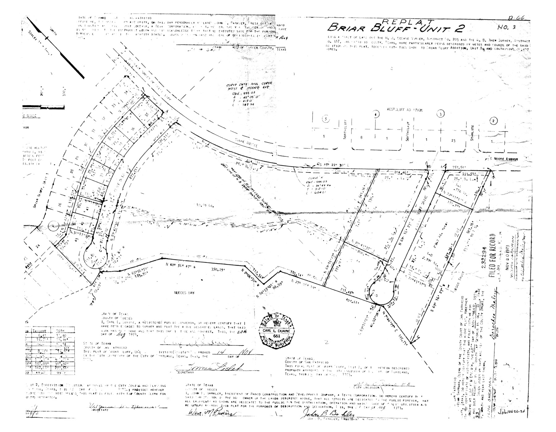
Boundary Survey of 15.97 Acres Being a Portion of 10.89 Acre Tract and All Lots 1B, 2 & 3, Replat of Briar Bluff Unit 2, San Patricio County, Texas
-
Map/Doc
8377
-
Collection
General Map Collection
-
Object Dates
1983/5/5 (Creation Date)
1983/12/5 (File Date)
-
People and Organizations
George M. Pyle (Surveyor/Engineer)
-
Counties
San Patricio
-
Subjects
Surveying Rolled Sketch
-
Height x Width
18.0 x 23.1 inches
45.7 x 58.7 cm
Part of: General Map Collection
Culberson County Working Sketch 58

Print $20.00
- Digital $50.00
Culberson County Working Sketch 58
1974
Size 45.2 x 35.1 inches
Map/Doc 68512
Lubbock County Working Sketch 9

Print $40.00
- Digital $50.00
Lubbock County Working Sketch 9
1990
Size 28.5 x 57.3 inches
Map/Doc 70669
Map of Bandera County

Print $40.00
- Digital $50.00
Map of Bandera County
1885
Size 31.3 x 60.9 inches
Map/Doc 3273
Clay County Working Sketch 6

Print $20.00
- Digital $50.00
Clay County Working Sketch 6
1923
Size 30.0 x 24.1 inches
Map/Doc 68029
Cottle County Rolled Sketch 7

Print $20.00
- Digital $50.00
Cottle County Rolled Sketch 7
Size 36.8 x 33.0 inches
Map/Doc 8675
Young County Working Sketch 28

Print $20.00
- Digital $50.00
Young County Working Sketch 28
1985
Size 29.9 x 26.0 inches
Map/Doc 62051
Map of Jefferson County

Print $20.00
- Digital $50.00
Map of Jefferson County
1840
Size 34.8 x 27.0 inches
Map/Doc 3726

Bell County Sketch File 35

Print $40.00
- Digital $50.00
Bell County Sketch File 35
1952
Size 22.0 x 24.3 inches
Map/Doc 10918
Grayson County Boundary File 1

Print $24.00
- Digital $50.00
Grayson County Boundary File 1
Size 12.8 x 8.2 inches
Map/Doc 53916
Swisher County Rolled Sketch 3

Print $20.00
- Digital $50.00
Swisher County Rolled Sketch 3
Size 21.3 x 19.4 inches
Map/Doc 7904
Travis County Appraisal District Plat Map 2_2204

Print $20.00
- Digital $50.00
Travis County Appraisal District Plat Map 2_2204
Size 21.6 x 26.4 inches
Map/Doc 94201
You may also like
Jefferson County Working Sketch 10

Print $40.00
- Digital $50.00
Jefferson County Working Sketch 10
1942
Size 35.0 x 49.4 inches
Map/Doc 66553
Rockwall County Boundary File 76

Print $14.00
- Digital $50.00
Rockwall County Boundary File 76
Size 11.4 x 8.9 inches
Map/Doc 58497
Galveston County Aerial Photograph Index Sheet 4

Print $20.00
- Digital $50.00
Galveston County Aerial Photograph Index Sheet 4
1953
Size 23.5 x 19.4 inches
Map/Doc 83695
Comanche County Working Sketch 30

Print $20.00
- Digital $50.00
Comanche County Working Sketch 30
1988
Size 18.8 x 28.2 inches
Map/Doc 68164
Cherokee County Sketch File 34

Print $12.00
- Digital $50.00
Cherokee County Sketch File 34
1954
Size 11.2 x 8.9 inches
Map/Doc 18198
Cram's Superior Map of Illinois

Print $40.00
- Digital $50.00
Cram's Superior Map of Illinois
1903
Size 50.2 x 40.5 inches
Map/Doc 97110
Flight Mission No. BRA-7M, Frame 182, Jefferson County

Print $20.00
- Digital $50.00
Flight Mission No. BRA-7M, Frame 182, Jefferson County
1953
Size 18.5 x 22.3 inches
Map/Doc 85550

Texas Intracoastal Waterway - Port O'Connor to San Antonio Bay, Including Pass Cavallo

Print $20.00
- Digital $50.00
Texas Intracoastal Waterway - Port O'Connor to San Antonio Bay, Including Pass Cavallo
1957
Size 28.1 x 40.0 inches
Map/Doc 73372
Wichita County Sketch File 31

Print $20.00
- Digital $50.00
Wichita County Sketch File 31
1938
Size 27.6 x 39.4 inches
Map/Doc 10433
Kinney County Sketch File 26

Print $20.00
- Digital $50.00
Kinney County Sketch File 26
1928
Size 20.4 x 18.8 inches
Map/Doc 11945
Bell County Sketch File 35
Print $40.00
- Digital $50.00
Bell County Sketch File 35
1952
Size 22.0 x 24.3 inches
Map/Doc 10918